Tropical Depression 2 Forms Eastern Atlantic No Threat to Land
Tropical Depression 2 Forms Eastern Atlantic No Threat to Land

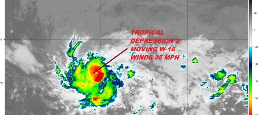
The vigorous tropical wave in the far Eastern Atlantic has developed a low level circulation this morning and we now have the season’s second tropical depression. Both the enhanced satellite picture above and the loop below show a fairly well defined system and conditions remain somewhat favorable for this to strengthen a bit as it moves westward at 16 mph. Due to the cooler than average ocean water temperatures in the tropical atlantic, conditions are only marginally favorable for some strengthening and while this could become a tropical storm it should not get much beyond minimal tropical storm status. There is a lot of dry air surrounding the depression and even if it were to strengthen some, it will run into hostile wind conditions to its west and it should weaken over the weekend as it nears the Leeward Islands.
WIDE ATLANTIC TROPICAL SATELLITE

...TROPICAL DEPRESSION FORMS OVER THE CENTRAL TROPICAL ATLANTIC...
...EXPECTED TO DISSIPATE EAST OF THE LESSER ANTILLES OVER THE
WEEKEND...


SUMMARY OF 1100 AM AST...1500 UTC...INFORMATION
-----------------------------------------------
LOCATION...10.2N 41.4W
ABOUT 1385 MI...2230 KM ESE OF THE LESSER ANTILLES
MAXIMUM SUSTAINED WINDS...35 MPH...55 KM/H
PRESENT MOVEMENT...W OR 270 DEGREES AT 16 MPH...26 KM/H
MINIMUM CENTRAL PRESSURE...1009 MB...29.80 INCHES


WATCHES AND WARNINGS
--------------------
There are no coastal watches or warnings in effect.


DISCUSSION AND OUTLOOK
----------------------
At 1100 AM AST (1500 UTC), the center of Tropical Depression Two was
located near latitude 10.2 North, longitude 41.4 West.  The
depression is moving toward the west near 16 mph (26 km/h).  A fast
westward to west-northwestward motion is expected through the
weekend.

Maximum sustained winds are near 35 mph (55 km/h) with higher gusts.
Some strengthening is possible, and the depression could become a
tropical storm later today or on Friday.  The system is forecast to
degenerate into an open trough east of the Lesser Antilles over the
weekend.

The estimated minimum central pressure is 1009 mb (29.80 inches).


HAZARDS AFFECTING LAND
----------------------
None
WESTERN ATLANTIC TROPICAL SATELLITE

The system off the Southeast coast of the US remains rather disorganized and while there is a low level swirl showing up on the satellite loop, there aren’t any thunderstorms around the center and most of what is there is to the east of the weak low level center. Even if this were to organize, Friday’s cold front insures this either getting turned to the north and northeast or just getting absorbed by the frontal zone to the northwest. The National Hurricane Center rates this a 40 percent chance of developing.
As far as the local weather is concerned you can check the latest outlook for the weekend which is for sunshine cooler temperatures and lower humidity.
FiOS1 News Weather Forecast For Long Island
FiOS1 News Weather Forecast For New Jersey
FiOS1 News Weather Forecast For Hudson Valley