
Satellite pictures this morning show Tropical Depression 11 has not strengthened this afternoon but it could become a tropical storm tonight or on Tuesday. We have to wait for the shear to relax with models forecast it to do in about 12 hours or so. It need only relax a little. Winds are keeping thunderstorms east of the circulation center which is well defined on the visible loop.
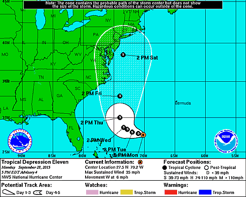
...DEPRESSION SHOWING LITTLE CHANGE IN STRENGTH AT THIS TIME...


SUMMARY OF 500 PM EDT...2100 UTC...INFORMATION
----------------------------------------------
LOCATION...27.5N 70.2W
ABOUT 465 MI...745 KM SW OF BERMUDA
MAXIMUM SUSTAINED WINDS...35 MPH...55 KM/H
PRESENT MOVEMENT...W OR 270 DEGREES AT 6 MPH...9 KM/H
MINIMUM CENTRAL PRESSURE...1003 MB...29.62 INCHES


We continue to watch this system as it becomes a player with all the action that is going on along the east coast. There are several pieces regarding the setup here. The latest one this afternoon focuses on the European model which shows a very robust tropical system and a pretty extreme but interesting solution late this week and into the weekend. Please also be sure to read my post earlier this morning regarding how all this plays out and how Tropical Depression 11 holds the key to drought breaking.
Back a number of weeks ago I wrote a piece about what you need to get a tropical system to move up the east coast. You can read that for background but this is what the upper air is supposed to look like by the end of the week.
Again I am more interested here in how much moisture we can get out of this as the front and trough eventually absorb the tropical depression. Complicating all this even further is strong high pressure to the north that will create a very strong onshore flow later in the week. Needless to say much to watch and sort out in the coming days.
Be sure to download my weather app and subscribe to my forecasts. The app is free and the subscription is just 99 cents a month. The app is free of advertisement and there are no tracking or security issues.