
Satellite pictures this morning show Tropical Depression 11 getting better organized and it appears it could become a tropical storm later today if trends continue. The visible loop shows a better defined center through most of the thunderstorms still remain east and north of it. Conditions are somewhat favorable this afternoon for this to reach tropical storm strength.
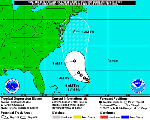
...DEPRESSION EXPECTED TO BECOME A TROPICAL STORM LATER TODAY...


SUMMARY OF 1100 AM AST...1500 UTC...INFORMATION
-----------------------------------------------
LOCATION...27.8N 69.6W
ABOUT 425 MI...680 KM SW OF BERMUDA
MAXIMUM SUSTAINED WINDS...35 MPH...55 KM/H
PRESENT MOVEMENT...WNW OR 295 DEGREES AT 5 MPH...7 KM/H
MINIMUM CENTRAL PRESSURE...1006 MB...29.71 INCHES


With regards to track with the upper air favorable for a move up the east coast the question is what is there if and when it gets up here. More than likely what will happen is that this will eventually transition over to a non tropical or extratropical low. The good news here is that if models are correct it will combine with a stall front and we will enhance the potential for drought busting rains here during the week. I will be update all this as new models lend better perspective on what may happen. Conditions are not conducive for this to become anything more than a miminal tropical storm however there could be some non tropical intensification possible once it makes the transition. Please be sure to read my post earlier this morning regarding how all this plays out and how Tropical Depression 11 holds the key to drought breaking.
Back a number of weeks ago I wrote a piece about what you need to get a tropical system to move up the east coast. You can read that for background but this is what the upper air is supposed to look like by the end of the week.

Again I am more interested here in how much moisture we can get out of this as the front and trough eventually absorb the tropical depression. Complicating all this even further is strong high pressure to the north that will create a very strong onshore flow later in the week. Needless to say much to watch and sort out in the coming days.
Be sure to download my weather app and subscribe to my forecasts. The app is free and the subscription is just 99 cents a month. The app is free of advertisement and there are no tracking or security issues.