Tropical Cyclone Development SW Gulf

Tropical Cyclone Development SW Gulf of Mexico
Latest satellite pictures are showing a well defined circulation moving across the Yucatan Peninsula and headed into the Southwest Gulf of Mexico. The satellite loop below shows it very well as the circulation emerges on the west side of the Yucatan. Convection also appears to be increasing during this evening and if trends continue, a tropical depression could form on Sunday. The NatIonal Hurricane Center rates this a 60 percent chance of doing so.
Tropical Cyclone Development SW Gulf Satellite Loop

Conditions are marginally favorable for development. However there doesn’t seem to be a mechanism to take this system northward. Instead it is more likely to move westward or west northwestward along or just north of the coastline in the Southwest Gulf of Mexico.
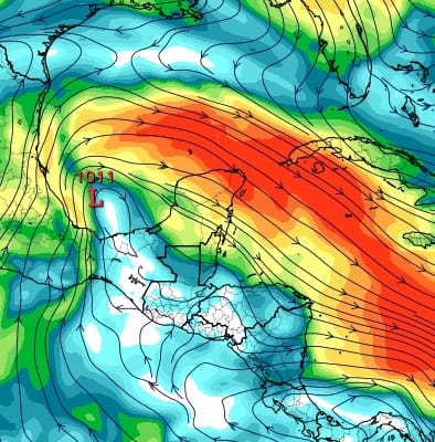
Tropical Cyclone Development SW Gulf Wind Shear Sunday Afternoon
The wind shear map above shows the low center over an area of light wind shear but this is not exceptionally favorable. We will monitor this of course during the day Sunday. The light blue and white area indicates winds at the highest levels of the atmosphere under 15 knots. The lighter the winds are aloft, the more favorable conditions are for development. Or at least they are less favorable for weakening if a system forms.
Elsewhere in the tropics there isn’t much going on. The rest of the Caribbean is free of clouds and the system in the Southwest Atlantic is non tropical in nature. The Tropical Atlantic also remains very quiet at the moment which is typical of late June.
Tropical Cyclone Development SW Gulf
Satellite Loop Western Atlantic

Tropical Cyclone Development SW Gulf
Satellite Loop Tropical Atlantic

JOESTRADAMUS HURRICANE SEASON GUEST FORECAST
FiOS1 News Weather Forecast For Long Island
FiOS1 News Weather Forecast For New Jersey
FiOS1 News Weather Forecast For Hudson Valley
NATIONAL WEATHER SERVICE SNOW FORECASTS
LATEST JOESTRADAMUS ON THE LONG RANGE
Weather App

Don’t be without Meteorologist Joe Cioffi’s weather app. It is really a meteorologist app because you get my forecasts and my analysis and not some automated computer generated forecast based on the GFS model. This is why your app forecast changes every 6 hours. It is model driven with no human input at all. It gives you an icon, a temperature and no insight whatsoever.
It is a complete weather app to suit your forecast needs. All the weather information you need is right on your phone. Android or I-phone, use it to keep track of all the latest weather information and forecasts. This weather app is also free of advertising so you don’t have to worry about security issues with your device. An accurate forecast and no worries that your device is being compromised.
Use it in conjunction with my website and my facebook and twitter and you have complete weather coverage of all the latest weather and the long range outlook. The website has been redone and upgraded. Its easy to use and everything is archived so you can see how well Joe does or doesn’t do when it comes to forecasts and outlooks.
Just click on the google play button or the apple store button on the sidebar for my app which is on My Weather Concierge. Download the app for free. Subscribe to my forecasts on an ad free environment for just 99 cents a month.
Get my forecasts in the palm of your hand for less than the cost of a cup of Joe!
![]()
![]()

MENTION JOE CIOFFI AND GET A 5% DISCOUNT