Tropical Cyclone Development Caribbean Next 2 Days
Tropical Cyclone Development Caribbean Next 2 Days

Looking at the latest satellite loop of the tropical disturbance in the Southwest Caribbean it appears to be getting better organized. There is some curvature developing and there may be the beginnings of a broad low level circulation. The National Hurricane Center has indicated that if necessary and Air Force plane will investigate the area later Wednesday afternoon. Conditions remain favorable for some development though the proximity to land may be a bit of an issue until it moves into the Northwest Caribbean where warm water temperatures and more room over open waters could allow for further development on Thursday or Friday.

To the north of this system is another area of disturbed weather associated with an upper trough. Low pressure may try to form here though upper level winds north of Cuba to Florida remain rather hostile for development. Eventually it will be the system in the Caribbean that will become the main focus as it makes its way eventually into the Gulf of Mexico.
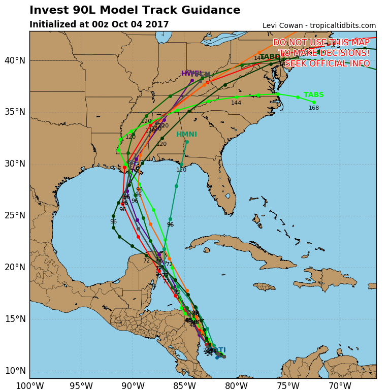
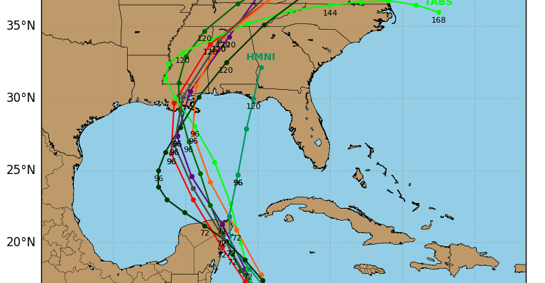
Early runs of hurricane tracking models all seem to make a move to the Northeast corner of the Yucatan Peninsula and the northward toward the Central Gulf Coast. The HWRF model is especially aggressive with the intensity but it is on the high end of the model range as others seem to be weaker. It seems reasonable that a tropical depression or tropical storm will develop from all this in the next few days. Weather models such as the European & the NAM model are much further to the east with the track and tend to bring it closer to the Eastern Gulf Coast rather than the Central Gulf Coast. We will evaluate the overnight weather models and have more on this during the day on Wednesday.
MANY THANKS TO TROPICAL TIDBITS FOR THE WONDERFUL USE OF THE MAPS
 GET JOE A CIGAR IF YOU LIKE

SHOP THE JOESTRADAMUS STORE
Weather App

Don’t be without Meteorologist Joe Cioffi’s weather app. It is really a meteorologist app because you get my forecasts and my analysis and not some automated computer generated forecast based on the GFS model. This is why your app forecast changes every 6 hours. It is model driven with no human input at all. It gives you an icon, a temperature and no insight whatsoever.
It is a complete weather app to suit your forecast needs. All the weather information you need is right on your phone. Android or I-phone, use it to keep track of all the latest weather information and forecasts. This weather app is also free of advertising so you don’t have to worry about security issues with your device. An accurate forecast and no worries that your device is being compromised.
Use it in conjunction with my website and my facebook and twitter and you have complete weather coverage of all the latest weather and the long range outlook. The website has been redone and upgraded. Its easy to use and everything is archived so you can see how well Joe does or doesn’t do when it comes to forecasts and outlooks.
Just click on the google play button or the apple store button on the sidebar for my app which is on My Weather Concierge. Download the app for free. Subscribe to my forecasts on an ad free environment for just 99 cents a month.
Get my forecasts in the palm of your hand for less than the cost of a cup of Joe!