Trending Warmer More Humid Weekend
2 Tropical Depressions Could Become Tropical Storms Tonight
We enjoyed what was probably the best weather day of the summer with lots of sunshine low humidity and reasonable temperatures all day long. Now we have another nice night ahead with clear skies. The satellite is showing some wispy clouds around but overall it should be clear overnight with most lows in the upper 50s to mid 60s with humidity still reasonable. We will have one more decent day on Friday with sunshine and it will still be comfortable though the dew points will come up a little. Highs will reach 80 to 85 in most places. There are no issues with showers as the radars are nice and quiet.
SATELLITE

REGIONAL RADAR

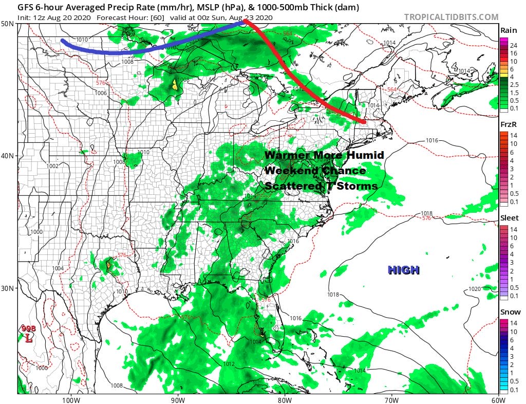
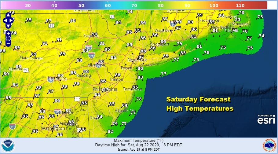
Heading into the weekend we will see very warm and humid conditions arrive for Saturday and Sunday. We should see some sunshine both days. There is the chance for a scattered shower or thunderstorm inland Saturday afternoon or evening but only a few of you will see anything. Highs will reach the middle 80s in most places.
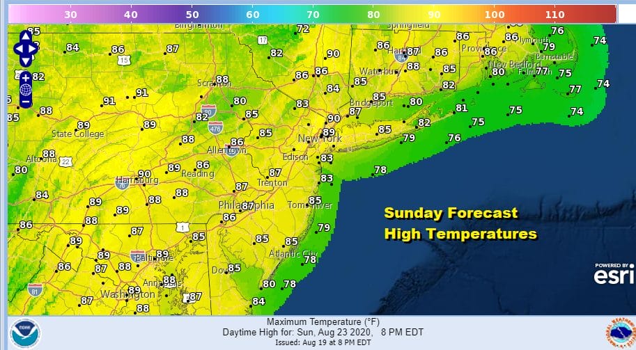
Sunday will be a summer day of some sunshine. Scattered showers and thunderstorms will pop up in the afternoon and evening. They will be a bit more numerous Sunday as opposed to Saturday but it should still be an okay day (unlike last Sunday). Highs will reach the upper 80s to near 90 and it will be a bit uncomfortable with the higher humidity.
There are no changes in the outlook for next week. It will be very warm through Thursday before a strong cold front arrives from the northwest. We have a weaker cold front moving through on Monday with the chance for a shower or thunderstorm and that might nudge the humidity a little lower Tuesday into Wednesday before the humidity comes back up again. Highs will be in the mid 80s to near 90 Monday and perhaps a little lower Tuesday and Wednesday before it goes higher on Thursday.
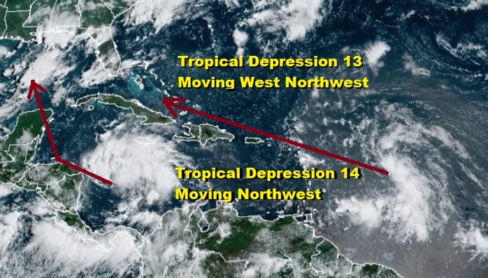
TROPICAL DEPRESSION 13 IN THE TROPICAL ATLANTIC
COULD BECOME A TROPICAL STORM TONIGHT OR FRIDAY
LOCATION…16.7N 53.9W
ABOUT 615 MI…990 KM E OF THE NORTHERN LEEWARD ISLANDS
MAXIMUM SUSTAINED WINDS…35 MPH…55 KM/H
PRESENT MOVEMENT…WNW OR 290 DEGREES AT 21 MPH…33 KM/H
MINIMUM CENTRAL PRESSURE…1008 MB…29.77 INCHES
A Tropical Storm Watch is in effect for Puerto Rico, Vieques and Culebra, U.S. Virgin Islands,British Virgin Islands,Saba and St. Eustatius, St. Maarten, St. Martin and St. Barthelemy, Antigua, Barbuda, St. Kitts, Nevis, and Anguilla.
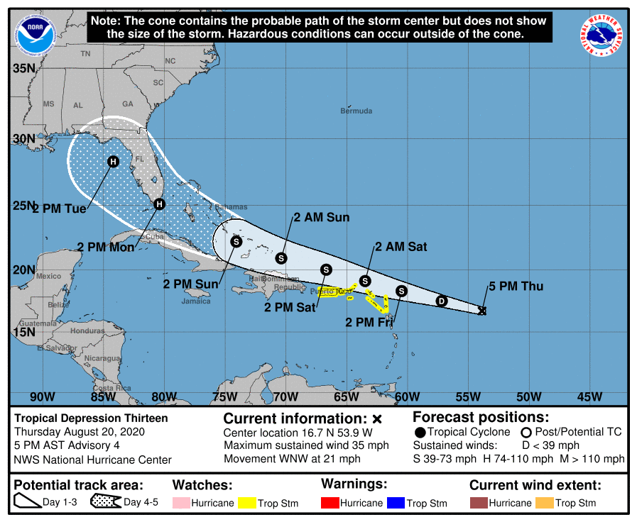
The forecast track of Tropical Depression 13 is west northwest into the Eastern Gulf of Mexico. Strengthening will depend on how close the system passes near the islands. It is now forecast by most models to pass north of the islands which would favor gradual strengthening along the way but as always the intensity forecast is never easy.
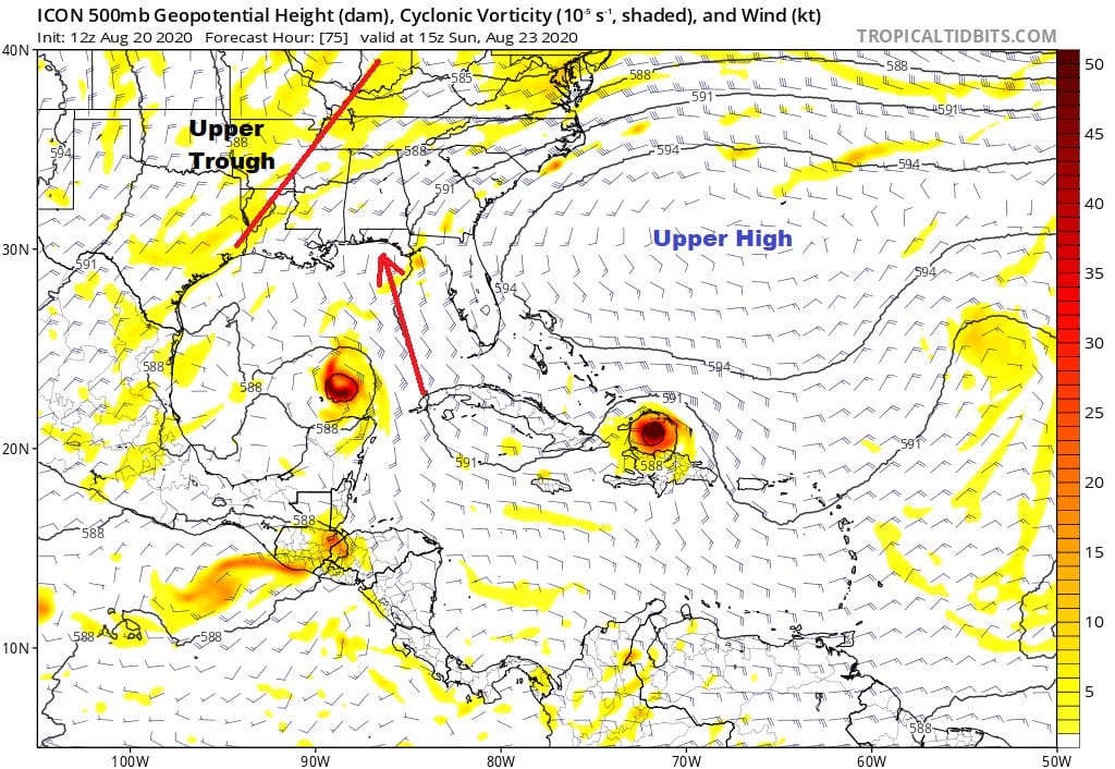
The track is around the strong upper high off the East Coast which is built back westward into the Eastern Gulf of Mexico. This allows Tropical Depression 13 in whatever form it is in to track around the base of the high and then make the turn into the Eastern Gulf of Mexico. The system will pass close to Florida so interests in South Florida should pay attention to this going forward. Nothing is imminent yet by any means. Tropical Depression 14 is in the Caribbean and it shows up on the map above North of the Yucatan Peninsula. It is going to respond to the weakness between the high to the east and another high to its west. That opens the door for a track to the Central or Western Gulf Coast.
5PM LOCATION…14.3N 81.0W
ABOUT 155 MI…250 KM ESE OF CABO GRACIAS A DIOS ON NIC/HON BORDER
MAXIMUM SUSTAINED WINDS…35 MPH…55 KM/H
PRESENT MOVEMENT…W OR 270 DEGREES AT 18 MPH…30 KM/H
MINIMUM CENTRAL PRESSURE…1007 MB…29.74 INCHES
A Tropical Storm Warning is in effect for Honduras/Nicaragua border westward to Punta Castilla Honduras, Bay Islands of Honduras, Puerto Cabezas Nicaragua northward to the Honduras/Nicaragua border.
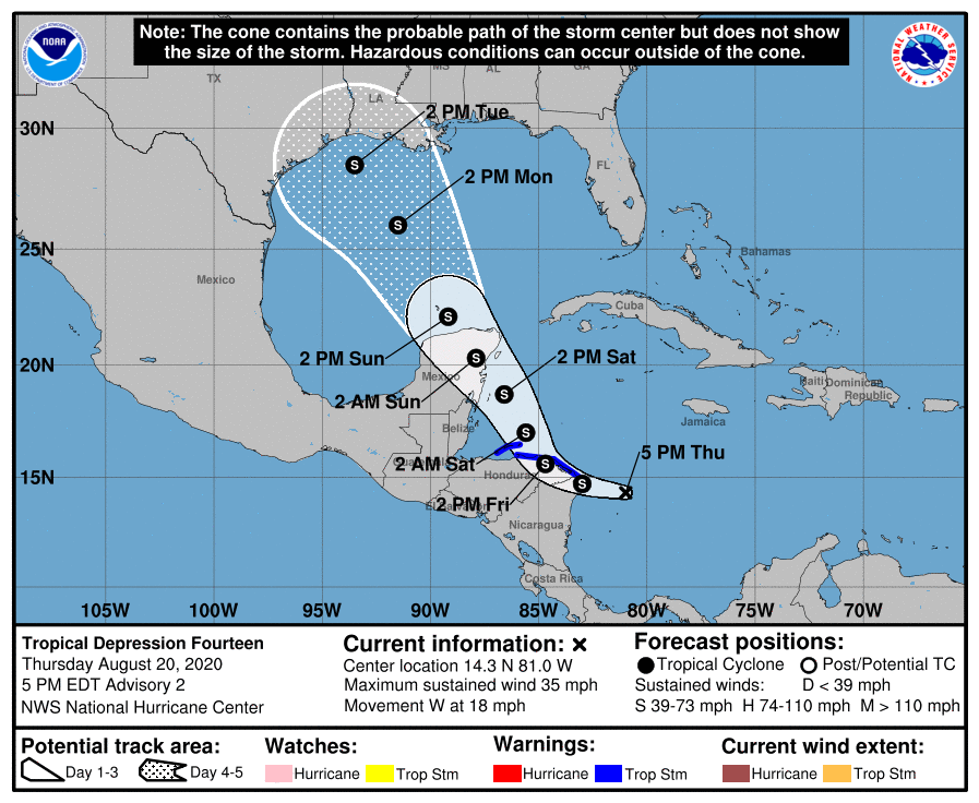
Here too the track forecast is a little easier than the intensity forecast as the system is likely to interact with land over Coastal Nicaragua and Honduras and later the Yucatan Peninsula before it emerges into the Gulf of Mexico so figuring out how strong this system gets is going to be a real challenge. It is quite possible if these forecasts verify that we will have twin tropical cyclones hitting the US mainland on the same day and that hasn’t happened since September 3, 1933!
BE SURE TO DOWNLOAD THE FREE METEOROLOGIST JOE CIOFFI WEATHER APP &
ANGRY BEN’S FREE WEATHER APP “THE ANGRY WEATHERMAN!
MANY THANKS TO TROPICAL TIDBITS FOR THE USE OF MAPS
Please note that with regards to any severe weather, tropical storms, or hurricanes, should a storm be threatening, please consult your local National Weather Service office or your local government officials about what action you should be taking to protect life and property.


