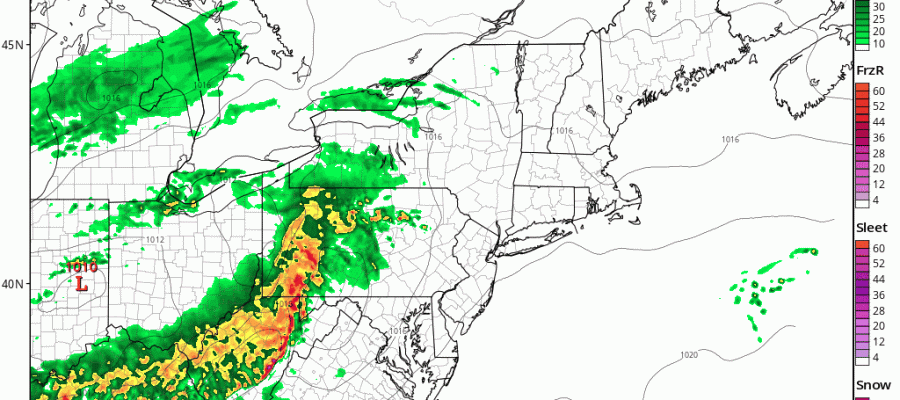
Thunderstorms Early Saturday Morning

Thunderstorms Early Saturday Morning
We are enjoying a warm and rather sunny afternoon although there is some fog lingering right along immediate coastal areas of Long Island Connecticut & parts of New Jersey. Temperatures have risen into the upper 70s and lower 80s. We will do this again on Saturday but there will be an early morning interruption and fireworks display in the form of some thunderstorms that look to move through between 4am and 8am. The HRRR model and the RAP models are very bullish on this idea. An upper air disturbance is being ejected eastward from the Ohio Valley and looks to flare up as it goes by.
HRRR THUNDERSTORMS EARLY SATURDAY MORNING CLICK TO ANIMATE

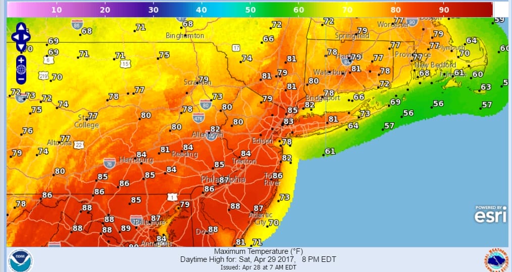
This area is moving very fast and once it moves offshore the sun should come out rather quickly and temperatures will shoot higher into the upper 70s to middle 80s. The wind will be westerly which means even coastal areas will warm up Saturday.
THUNDERSTORMS EARLY SATURDAY, AFTERNOON FORECAST HIGHS
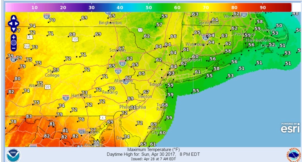
A back door front will drop through the area Saturday night which means Sunday will be 20 degrees cooler with an ocean wind and lots of clouds. Temperatures in coastal areas probably won’t get out of the 50s.
Monday it is a strong southwest flow which means inland areas will warm up back toward 80 with some late thunderstorms. A cold front moves through Monday night and dry air returns Tuesday.
MANY THANKS TO TROPICAL TIDBITS FOR THE WONDERFUL USE OF THE MAPS

GET JOE A CIGAR IF YOU LIKE!
LANDSCAPE COMPANIES FOR YOUR SPRING SUMMER FALL NEEDS
LONG ISLAND ROCKLAND COUNTY Connecticut

![]()

ROCKLAND COUNTY TRI STATE SNOW REMOVAL JOHNSTOWN PA


FiOS1 News Weather Forecast For Long Island
FiOS1 News Weather Forecast For New Jersey
FiOS1 News Weather Forecast For Hudson Valley
NATIONAL WEATHER SERVICE SNOW FORECASTS
LATEST JOESTRADAMUS ON THE LONG RANGE
Weather App

Don’t be without Meteorologist Joe Cioffi’s weather app. It is really a meteorologist app because you get my forecasts and my analysis and not some automated computer generated forecast based on the GFS model. This is why your app forecast changes every 6 hours. It is model driven with no human input at all. It gives you an icon, a temperature and no insight whatsoever.
It is a complete weather app to suit your forecast needs. All the weather information you need is right on your phone. Android or I-phone, use it to keep track of all the latest weather information and forecasts. This weather app is also free of advertising so you don’t have to worry about security issues with your device. An accurate forecast and no worries that your device is being compromised.
Use it in conjunction with my website and my facebook and twitter and you have complete weather coverage of all the latest weather and the long range outlook. The website has been redone and upgraded. Its easy to use and everything is archived so you can see how well Joe does or doesn’t do when it comes to forecasts and outlooks.
Just click on the google play button or the apple store button on the sidebar for my app which is on My Weather Concierge. Download the app for free. Subscribe to my forecasts on an ad free environment for just 99 cents a month.
Get my forecasts in the palm of your hand for less than the cost of a cup of Joe!
![]()


