Sunshine Warm Near Record Highs Over the Weekend
Watching Developing Low East of Florida Next Week

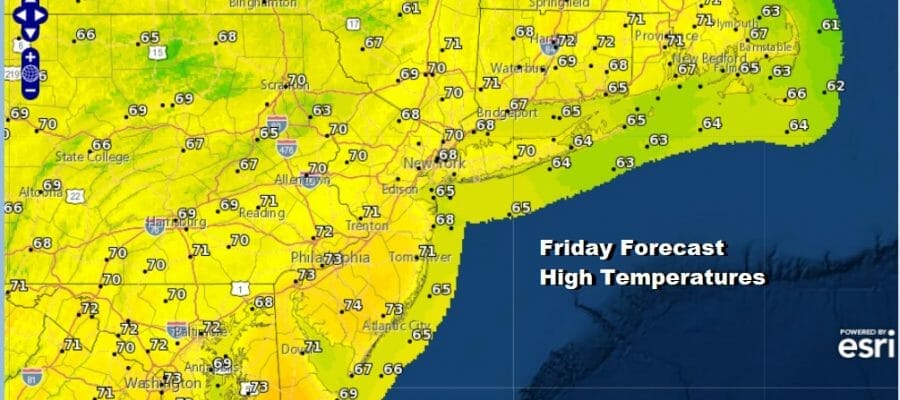
Day 3 of nice warm weather conditions continue in the Northeast and Middle Atlantic states. We have another day of sunshine. Three isn’t much of anything at all going on satellite or radar wise and that makes the forecast a rather easy one. High temperatures this afternoon will recah the upper 60s to lower 70s and we could see some areas in warm spots push the envelope a little above the top end of the range. High pressure is offshore and we will begin to see the wind shift more to the south and southwest tonight and over the weekend and that sets us up for some very warm temperatures.
SATELLITE

WEATHER RADAR

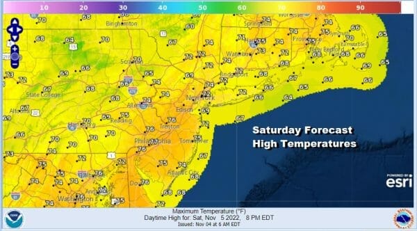
Long November nights and a warm air mass are a recipe for low clouds and fog overnight and we could certainly see some of this especially inland in cooler valleys where cooler air tends to pool and warmer air aloft causes fog to develop. Most lows overnight will be in the 50s to near 60. Saturday will be a day of sunshine and the potential for record highs in some places once the the morning fog (if any) burns off. Highs will reach the middle 70s in many areas and possibly we could push that to the upper 70s.
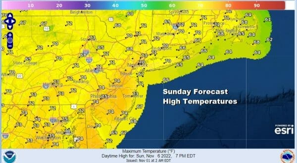
Sunday will be another very warm day with the potential for record highs. We will have a cold front approaching from the west. That front is very active today and Saturday with severe weather in the lower and middle Mississippi Valley, however we still have a ridge in the upper atmosphere in the East and that front will weaken as it approaches.

This weather front falls apart and so does the area of approaching showers. This should leave us on Sunday with probably more in the way of clouds but it may be no worse than partly sunny at least for the start of the day. We are not putting rain in the forecast. Temperatures will be once again in the middle to upper 70s and in some cases that will be enough to produce record highs.
Next week sets up to be an interesting week with a lot going on. Firstly for the Northeast and Middle Atlantic we will have one more warm day Monday with highs into the 70s with a mix of clouds and some sun. High pressure coming down from Canada will build in for the rest of the week. This is going to keep things dry through Friday. It will also cool temperatures down back to average with highs back in the 50s Tuesday, Wednesday and possibly Thursday.

This high is creating an area of higher than normal pressures in the East and lower than normal pressrues off the Florida coast and the Bahamas. Low pressure develops there this week and there is a possibility that the low could develop into a tropical or subtropical depression or storm. What we can say for sure is that next week we will once again see 5 days of no rain however if this low does materialize, a cold front and that moisture will combine at the very least to bring rain to the Northeast and Middle Atlantic next weekend. We will be watching for the possibility of tropical storm formation as that adds an extra added complication potentially but this is still many days away. In the meantime enjoy your Friday and weekend.
BE SURE TO DOWNLOAD THE FREE METEOROLOGIST JOE CIOFFI WEATHER APP &
ANGRY BEN’S FREE WEATHER APP “THE ANGRY WEATHERMAN!
MANY THANKS TO TROPICAL TIDBITS & F5 WEATHER FOR THE USE OF MAPS
Please note that with regards to any severe weather, tropical storms, or hurricanes, should a storm be threatening, please consult your local National Weather Service office or your local government officials about what action you should be taking to protect life and property.


