Summer Heat Relief Close By Long Range

Summer Heat Relief Close By Long Range
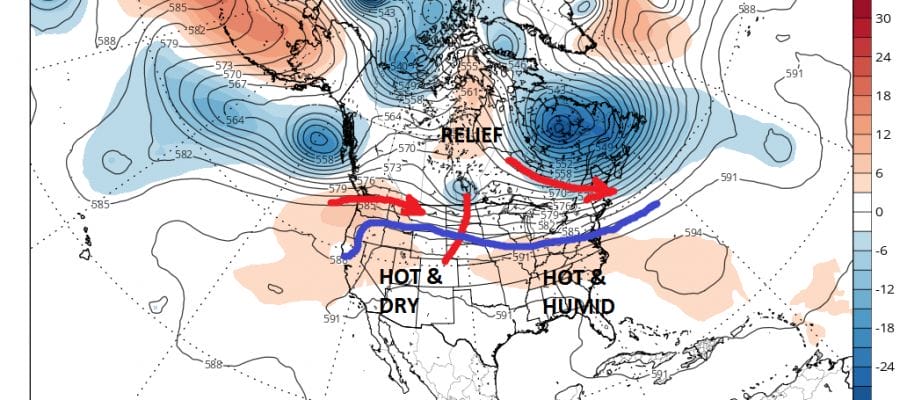
We are in the hottest part of the summer which is usually from mid July to early August. Average temperatures peak during this 3 week period and our weather seem to be playing out this way. The upper air pattern has been pretty much the same except that the jet stream has pulled up just far enough north to bring heat and humidity to much of the southern areas of the Northeast & Middle Atlantic states. The flexing of that jet stream further south will bring shreds of relief to the heat so as not to make it 90 degrees continuously and the occasional breaks in the humidity will come with it.
SUMMER HEAT EUROPEAN WEATHER MODEL SATURDAY 7/22/2017
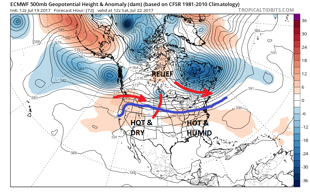
The European model run today shows this occasional flexing of the jet stream. The first comes on Saturday where we could see the humidity levels drop slightly and temperatures ease a bit, though it will still hit upper 80s to near 90 degrees. A stronger shortwave trough will attempt to move through on Monday so as it approaches we could see some showers and thunderstorms with that. There should be a stronger shot of relief later Tuesday into Wednesday of next week.
SUMMER HEAT EUROPEAN MODEL JET STREAM PATTERN MONDAY JULY 24 2017
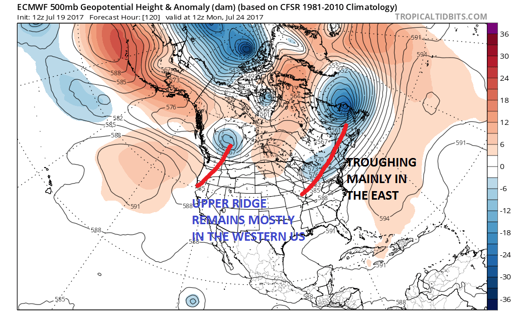
This really is a continuation of the same pattern we have been in for weeks. There appears to be no sign of a change in the signature pattern of a trough in the Eastern US and the ridge in the west. If this pattern continues to hold into August we may begin to see more robust cooler air masses dropping down into the Great Lakes & Northeast. Of course there is no guarantee that it will stay the same and there is nothing that says that the ridge could shift to the East Coast in August. For now the trend remains your friend in the forecast world and there is no reason to change the outlook until proven otherwise.
SUMMER HEAT GFS MODEL JET STREAM AUGUST 4TH 2017

The GFS model which takes us out to the end of the second week in the long range suggests that the ridge in the west gets stronger which may lead to a deeper trough in the east. One of the things that we will need to begin paying more attention to is the position of that trough and whether it comes along at a time when a tropical storm or hurricane is running around. That will come under increasing scrutiny as we head into August & September.
MANY THANKS TO TROPICAL TIDBITS FOR THE WONDERFUL USE OF THE MAPS

GET JOE A CIGAR IF YOU LIKE!
Weather App

Don’t be without Meteorologist Joe Cioffi’s weather app. It is really a meteorologist app because you get my forecasts and my analysis and not some automated computer generated forecast based on the GFS model. This is why your app forecast changes every 6 hours. It is model driven with no human input at all. It gives you an icon, a temperature and no insight whatsoever.
It is a complete weather app to suit your forecast needs. All the weather information you need is right on your phone. Android or I-phone, use it to keep track of all the latest weather information and forecasts. This weather app is also free of advertising so you don’t have to worry about security issues with your device. An accurate forecast and no worries that your device is being compromised.
Use it in conjunction with my website and my facebook and twitter and you have complete weather coverage of all the latest weather and the long range outlook. The website has been redone and upgraded. Its easy to use and everything is archived so you can see how well Joe does or doesn’t do when it comes to forecasts and outlooks.
Just click on the google play button or the apple store button on the sidebar for my app which is on My Weather Concierge. Download the app for free. Subscribe to my forecasts on an ad free environment for just 99 cents a month.
Get my forecasts in the palm of your hand for less than the cost of a cup of Joe!
![]()
