Strong Tropical Wave Moving West
Strong Tropical Wave Moving West
We can see on the satellite loop a strong tropical wave moving westward into the Eastern Caribbean this afternoon. So far no surface circulation is indicated through the curvature of the clouds suggests that there is something trying to develop perhaps at mid levels. The wave is moving at a pretty good clip to the west. It is tracking behind an upper air low that is moving across the Florida Straits and into the Gulf of Mexico. Typically systems usually have a tough time developing in the Eastern Caribbean and conditions are almost always more favorable in the Western Caribbean where the wave will be in about 2 days. The Tropical Weather Outlook from the National Hurricane Center is below.
Strong tropical wave moving west Satellite Loops


TROPICAL WEATHER OUTLOOK
NWS NATIONAL HURRICANE CENTER MIAMI FL
200 PM EDT SUN JUL 31 2016

For the North Atlantic...Caribbean Sea and the Gulf of Mexico:

1. Showers and thunderstorms associated with a strong and fast-moving
tropical wave over the eastern Caribbean Sea have changed little in
organization this morning, and there are still no signs of a closed
surface circulation.  Although some gradual development of this
system is possible during the next day or so, the chance for
tropical cyclone formation should increase after the wave reaches
the western Caribbean Sea in a couple of days.  This disturbance is
expected to cause locally heavy rains and gusty winds over portions
of the Lesser Antilles, the Virgin Islands, and Puerto Rico today
and tonight.  These conditions should spread westward across the
central Caribbean Sea and reach Hispaniola by Monday and Jamaica and
Cuba by Tuesday.  Interests in these areas and elsewhere in the
Caribbean Sea should continue to monitor the progress of this
system.  For additional information on this system, see High Seas
Forecasts issued by the National Weather Service.
* Formation chance through 48 hours...medium...40 percent
* Formation chance through 5 days...high...70 percent
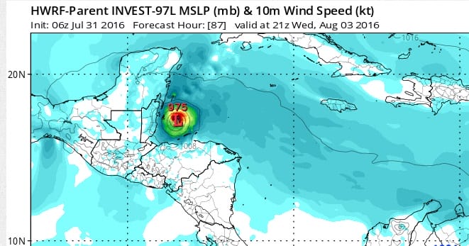
Weather models of course have varying ideas here. One of the hurricane models has this system becoming a hurricane by Wednesday as it approaches the Yucatan Peninsula. Conditions appear favorable for development as the upper air wind shear environment is weak and there will be an upper high aloft over the system which will allow it to strengthen.
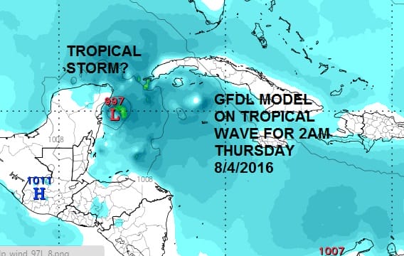
Strong tropical wave moving west Hurricane Models
We also have the GFDL model which develops this into a tropical storm in the central Caribbean on Tuesday and keeps it at that strength as it heads toward the Yucatan Peninsula by Thursday morning.

It seems that the global models want to form a circulation further south than the hurricane models and straddle it along 15N with very little development. The easterlies are fairly deep right now thanks to the strong ridge to the north. Whether there is enough weakness in that ridge to allow for a more northward component of motiion remains to be seen. This is the first test for weather models to see how they handle tropical systems since their upgrades so let’s see what happens. It should be noted that the GFDL develops the system behind this one into a hurricane as it approaches the Leeward Islands late this week but we are not even remotely ready to bite into that particular apple since none of the other models show anything remotely close to a weak wave let alone a full blown hurricane. One day at a time folks.
WEATHER VIDEO ON TODAY’S DOWNPOURS AND A LOOK AT THE TROPICS
[brid video=”56770″ player=”6390″ title=”FLASH FLOOD WATCH NJ NY TROPICS”]
FiOS1 News Weather Forecast For Long Island
FiOS1 News Weather Forecast For New Jersey
FiOS1 News Weather Forecast For Hudson Valley
NATIONAL WEATHER SERVICE SNOW FORECASTS
LATEST JOESTRADAMUS ON THE LONG RANGE
Weather App

Don’t be without Meteorologist Joe Cioffi’s weather app. It is really a meteorologist app because you get my forecasts and my analysis and not some automated computer generated forecast based on the GFS model. This is why your app forecast changes every 6 hours. It is model driven with no human input at all. It gives you an icon, a temperature and no insight whatsoever.
It is a complete weather app to suit your forecast needs. All the weather information you need is right on your phone. Android or I-phone, use it to keep track of all the latest weather information and forecasts. This weather app is also free of advertising so you don’t have to worry about security issues with your device. An accurate forecast and no worries that your device is being compromised.
Use it in conjunction with my website and my facebook and twitter and you have complete weather coverage of all the latest weather and the long range outlook. The website has been redone and upgraded. Its easy to use and everything is archived so you can see how well Joe does or doesn’t do when it comes to forecasts and outlooks.
Just click on the google play button or the apple store button on the sidebar for my app which is on My Weather Concierge. Download the app for free. Subscribe to my forecasts on an ad free environment for just 99 cents a month.
Get my forecasts in the palm of your hand for less than the cost of a cup of Joe!