
Strong Blocking Pattern Develops Late Month Warm Until Then

Strong Blocking Pattern Develops Late Month Warm Until Then
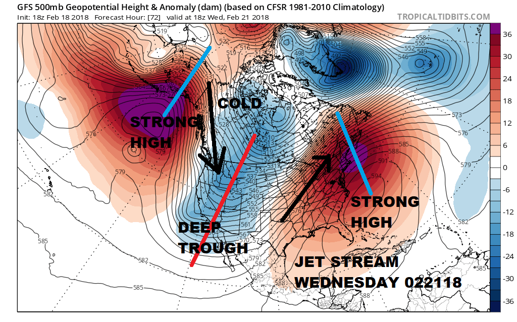
As we look at the long range we see two things. In the short term temperatures for the most part will be above average and on some days well above average. Other than local sea breezes or days with a south or southeast wind, we will see temperatures Tuesday and Wednesday in the 60s and even some 70s are possible in some areas. Clouds will also play a role in how high it does or doesn’t get. The upper air jet stream pattern is stretched to an extreme on both costs with a ridge of high pressure aloft in the east , a deep trough in the west, and a strong ridge in the Gulf of Alaska.
JET STREAM PATTERN WEDNESDAY FEBRUARY 21, 2018
However all the models show the slow grinding process of pattern change getting underway as all the chess pieces get moved around into new positions. The North Atlantic Oscillation or NAO which is an indicator of blocking in the Atlantic looks to take center stage in a big way. While we have seen the NAO appear from time to time it hasn’t been able to hold on for more than a few days or a week or two. This signal is exceptionally strong as indicated by the ensembles overnight.
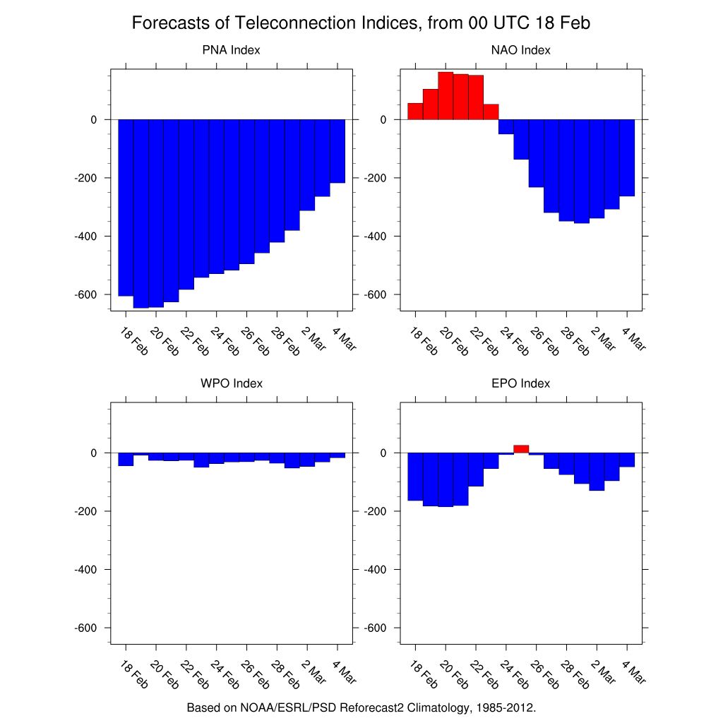
The crash in the NAO index begins late this week and then goes off the wall negative in value as the month ends and moves into March. This is signalling a complete break down in the strong ridge in the Eastern US that is pumping up very warm air. Meanwhile the other side of this equation is the Pacific North America index or PNA which is giving a reading that is as negative as I have ever seen it. This is reflecting the pattern of the strong ridge in the East and the deep trough in the west. The extreme reading is the primary reason why we will be so warm this week. While the PNA then trends higher into next month it is still very negative. If it is going to turn colder in the East it would take strong blocking as indicated by the NAO. We seem to have exactly that.
JET STREAM PATTERN WEDNESDAY FEBRUARY 28, 2018
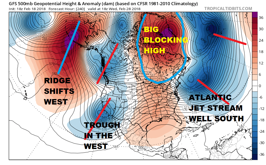
What the block does is that it displaces the jet stream in the Atlantic well to the south of normal. Higher pressures build across Greenland and Eastern Canada which supplies low level cold air to an extent. Meanwhile the west is still a bit of a mess with the deep trough along the West Coast. This brings us to the beginning of March. It would seem that with this blocking pattern in place we will have to look closely to see if this will eventually lead to storm development along the East Coast. This is by no means guaranteed by any means. The position of the high to the northeast will be among many critical keys in the long term forecast. You can have all the blocking in the world but if the troughs and ridges are all in the wrong place it won’t lead any serious problems other than a dry colder pattern for the first two weeks of March. But the blocking does open up a window of opportunity for something of size to happen going forward and will require close watching going forward. Be forewarned that going forward you are likely to see all sorts of social media posts of maps from various models. Ignore those for now and focus on the overall pattern until we get into a much shorter range when it becomes more practical and sensible to evaluate storm potential if any.
SHOP THE JOESTRADAMUS STORE
MANY THANKS TO TROPICAL TIDBITS FOR THE WONDERFUL USE OF THE MAPS

GET JOE A CIGAR IF YOU LIKE!
FiOS1 News Weather Forecast For Long Island
FiOS1 News Weather Forecast For New Jersey
FiOS1 News Weather Forecast For Hudson Valley
NATIONAL WEATHER SERVICE SNOW FORECASTS
LATEST JOESTRADAMUS ON THE LONG RANGE