Stormy Pattern Lies Ahead
Stormy Pattern Lies Ahead
We continue to see the weather pattern get more stormy going forward as we move into December. The 2 day rain we are experiencing now is a good sign that the drought pattern stranglehold is beginning to weaken considerably. Yesterday’s rain was among the top 5 rainfalls of the year and it is the 3rd one on the last month. As the entire upper air pattern continues to evolve, we see several weather systems next week that will threaten. There is a lot of tension in the atmosphere. By this I mean that a number of indices are at or forecast to reach extremes. The continued warming over the polar regions and the displacement of the jet stream further south has finally opened up an alley way for storms to move across the United States with each one having potential to produce.
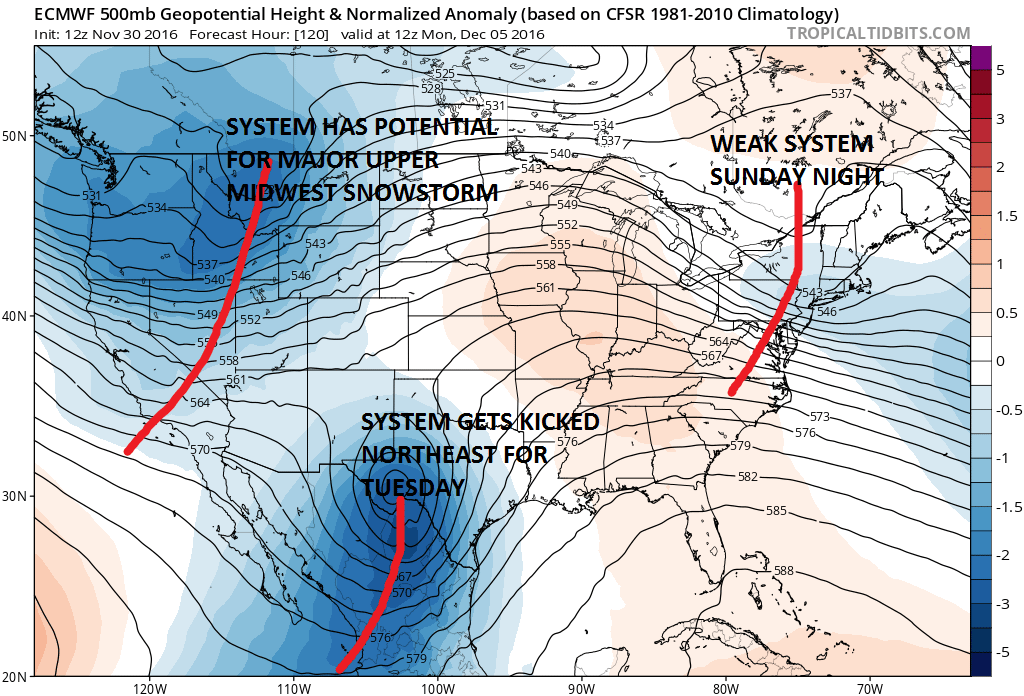
While all the model remain emotionally bi-polar from run to run, the European seems to make the most sense going forward at this point. The first system is a weak one that drops down from the northwest Sunday night and that could produce a light mix in some areas or even some snow though it looks weak. The moisture from this may wind up getting left behind to the west. The more important system is the one on the southwest that gets kicked out ahead of a third system in the northwest. Models have been having a lot of difficulty with this. Early model runs were making this into a major storm but now it seems this gets kicked out ahead of a third trough in the northwest. That one on the European becomes a major storm for the upper Midwest later next week.
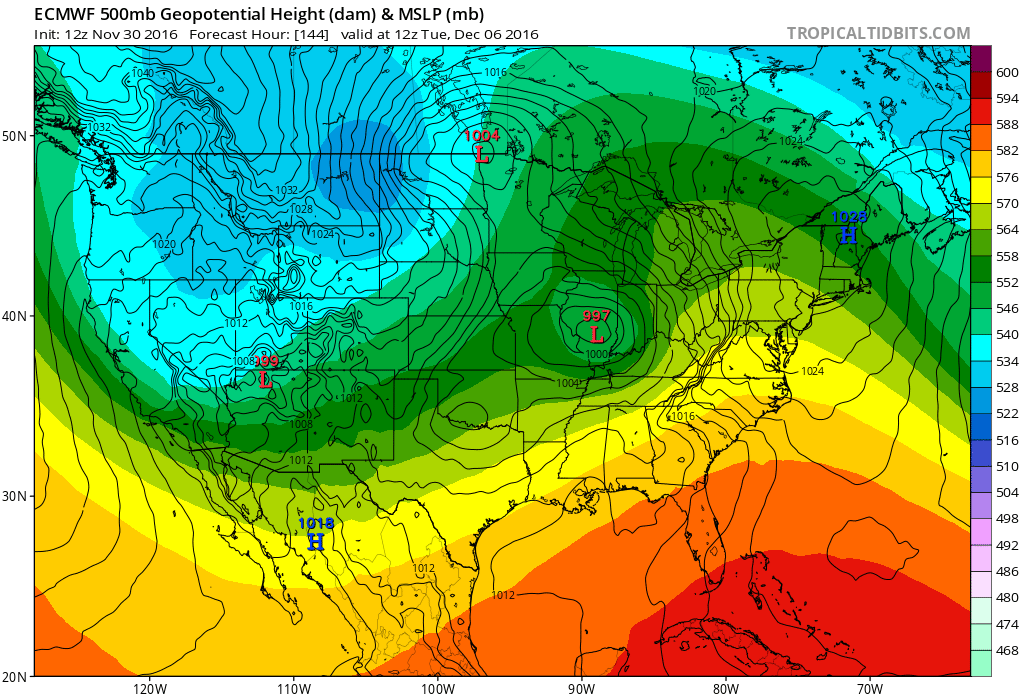
The European weather model has low pressure moving into the Ohio Valley and redeveloping along the coast as high pressure builds into New England. Cold air is marginal here but this could be pointing to some icing in areas well inland of the Northeast on Tuesday.
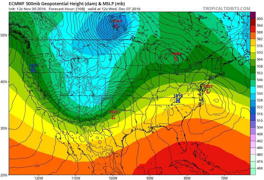
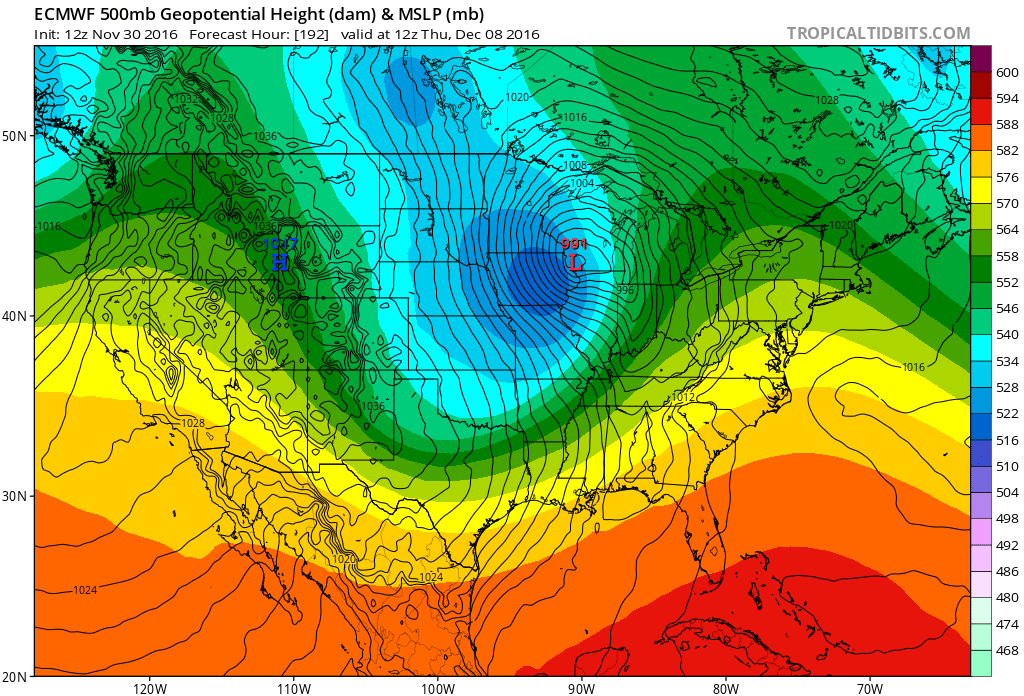
At the very least it means for 2 more substantial rain events for our area breaking the drought down even more. The third system in the midwest eventually moves to the east coast late next week and again more heavy rain will be produced with cold air behind it after it goes by.
Of course the bi polar nature of the models leads us to have low confidence overall but the more active jet stream pattern is absolutely going to be in play. The southwest system and how it gets kicked out will be key to how weather systems evolve next week. Interesting stormy times ahead.
MANY THANKS TO TROPICAL TIDBITS FOR THE WONDERFUL USE OF THE MAPS
SNOW REMOVAL COMPANIES FOR YOUR WINTER NEEDS
LONG ISLAND ROCKLAND COUNTY Connecticut

![]()


WINTER 2016-2017 PART 1 OCEAN WATER TEMPERATURES
WINTER 2016-2017 PART 2 ARCTIC SEA ICE AND SIBERIAN SNOW COVER
FiOS1 News Weather Forecast For Long Island
FiOS1 News Weather Forecast For New Jersey
FiOS1 News Weather Forecast For Hudson Valley
NATIONAL WEATHER SERVICE SNOW FORECASTS
LATEST JOESTRADAMUS ON THE LONG RANGE
Weather App

Don’t be without Meteorologist Joe Cioffi’s weather app. It is really a meteorologist app because you get my forecasts and my analysis and not some automated computer generated forecast based on the GFS model. This is why your app forecast changes every 6 hours. It is model driven with no human input at all. It gives you an icon, a temperature and no insight whatsoever.
It is a complete weather app to suit your forecast needs. All the weather information you need is right on your phone. Android or I-phone, use it to keep track of all the latest weather information and forecasts. This weather app is also free of advertising so you don’t have to worry about security issues with your device. An accurate forecast and no worries that your device is being compromised.
Use it in conjunction with my website and my facebook and twitter and you have complete weather coverage of all the latest weather and the long range outlook. The website has been redone and upgraded. Its easy to use and everything is archived so you can see how well Joe does or doesn’t do when it comes to forecasts and outlooks.
Just click on the google play button or the apple store button on the sidebar for my app which is on My Weather Concierge. Download the app for free. Subscribe to my forecasts on an ad free environment for just 99 cents a month.
Get my forecasts in the palm of your hand for less than the cost of a cup of Joe!
![]()