Storm Surge Forecast Hermine
Storm Surge Forecast Hermine
Tropical Storm Warning Coastal New Jersey
Tropical Storm Watch NE New Jersey, Long Island,
Southern Westchester, Coastal Connecticut
At least with respect to current weather conditions we are seeing high clouds coming up from the south in advance of Tropical Storm Hermine which is moving right along just inland of the coast in Northeast South Carolina. Tropical Storm Hermine will be moving off the North Carolina Coast Saturday morning and from there northeastward and slowing down to a crawl. It should begin to strengthen again. Models and the National Hurricane are forecasting this to become a strong tropical storm or some sort of hybrid semi post tropical hurricane. We can say at least that there are no weather worries tonight or for the daytime on Saturday, though rain could get close to Southern New Jersey late in the afternoon. Temperatures tonight will be in the pleasant 60s and even 50s in cool spots north and northwest of warmer urban areas and highs Saturday will be in the low to mid 70s depending on how thick the clouds get.


On the regional radar you can see the leading edge of the rains moving into Southern Virginia and there is a lot of rain in North Carolina. All of this is moving north northeast at about 15 mph or so.
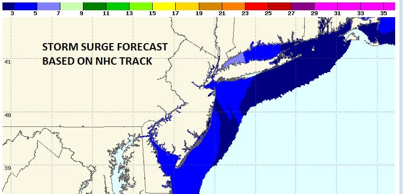
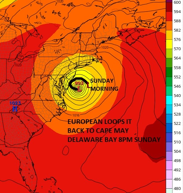
With regards to the storm surge forecast it is based on an offshore National Hurricane Center track. However if the European model track proves true where the center hooks northwest to near Delaware Bay, these surges will be higher than currently forecast. Right now surges for the Sunday night high tide are 3 to 5 feet with 5 to 7 feet possible in Western Long Island Sound. Again if the European is right the surge will be higher. These figures do not include waves but do include the height of the tide.

 There were no major changes in the mid runs of the models late this afternoon through they did trend further west. The new NAM model run begins shortly
FiOS1 News Weather Forecast For Long Island
FiOS1 News Weather Forecast For New Jersey
FiOS1 News Weather Forecast For Hudson Valley
NATIONAL WEATHER SERVICE SNOW FORECASTS
LATEST JOESTRADAMUS ON THE LONG RANGE
Weather App

Don’t be without Meteorologist Joe Cioffi’s weather app. It is really a meteorologist app because you get my forecasts and my analysis and not some automated computer generated forecast based on the GFS model. This is why your app forecast changes every 6 hours. It is model driven with no human input at all. It gives you an icon, a temperature and no insight whatsoever.
It is a complete weather app to suit your forecast needs. All the weather information you need is right on your phone. Android or I-phone, use it to keep track of all the latest weather information and forecasts. This weather app is also free of advertising so you don’t have to worry about security issues with your device. An accurate forecast and no worries that your device is being compromised.
Use it in conjunction with my website and my facebook and twitter and you have complete weather coverage of all the latest weather and the long range outlook. The website has been redone and upgraded. Its easy to use and everything is archived so you can see how well Joe does or doesn’t do when it comes to forecasts and outlooks.
Just click on the google play button or the apple store button on the sidebar for my app which is on My Weather Concierge. Download the app for free. Subscribe to my forecasts on an ad free environment for just 99 cents a month.
Get my forecasts in the palm of your hand for less than the cost of a cup of Joe!

MENTION JOE CIOFFI AND GET A 5% DISCOUNT


