

Storm Signals On GFS Model
The refrigerator repair man is here and he is working on the cold air compressor! The overnight GFS model was very dynamic in many ways. The model is sending out various storm signals as we move through the first 2 weeks of January. How they wind up specifcally playing out is going to depend on a lot of factors which we have no way of knowing at this very early stage of the game but let us deal with what we do know.
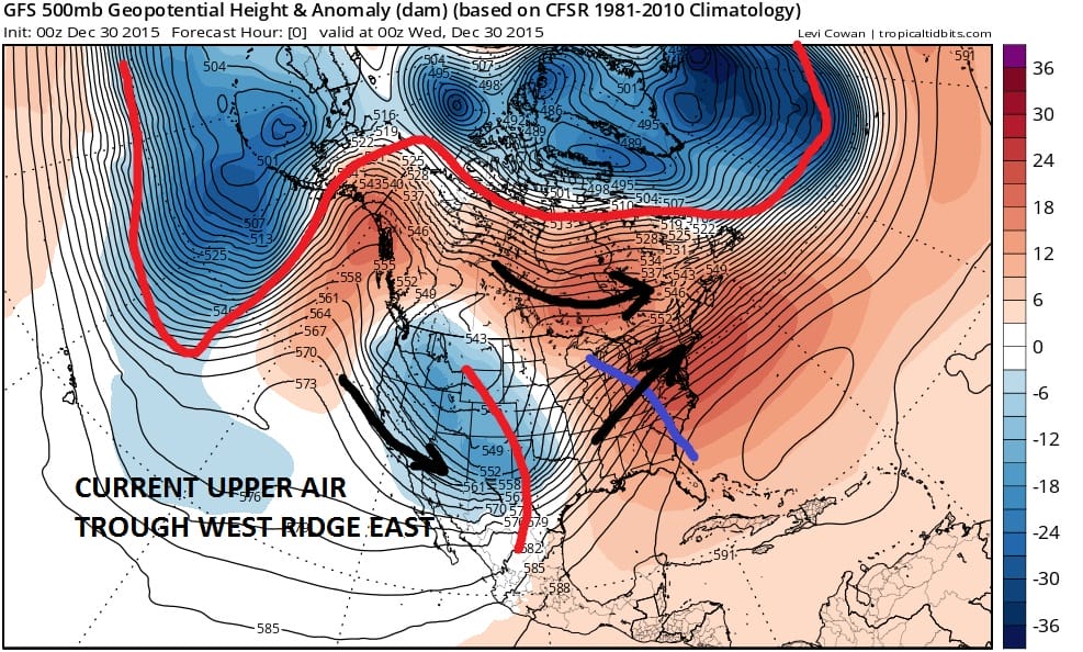
First let us look at the upper air pattern that is currently over us. Nothing has changed through today. The trough is in the west. The ridge is in the east. The arctic vortex is dominant and as locked up as it ever has been during the last 2 months.
Now watch what happens in just 4 days as the pattern change gets underway. The arctic vortex complex completely breaks down. A polar vortex forms in northern Canada and begins to dominate the flow in the Eastern United States. This is the upper air map for Saturday evening.
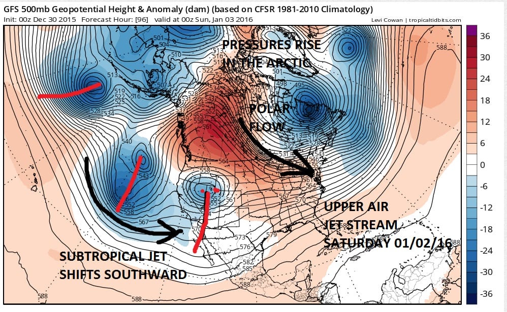
The other changes occur in the west where a ridge pops up into Northwest Canada, and the subtropical jet shifts southward by a good 300 or more miles so that storms now are aiming for Southern California and not the Pacific Northwest. This is a huge development because it now means that weather systems in the west will undercut the ridge and make their way across the southern tier. They will not be digging into the west and overwhelming the pattern any longer.
Now lets jump forward to day 10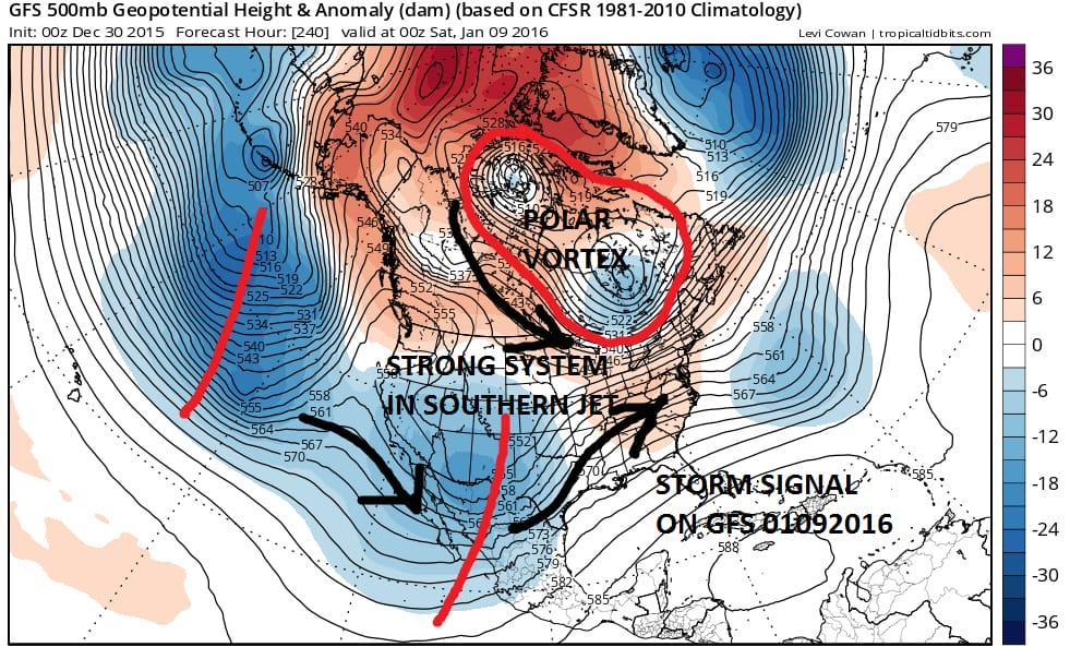
Notice the huge difference between day 10 and the current flow. The polar vortex is setting up across Eastern Canada. The system in the southwest is getting ejected east because there is another one behind it moving it along. There is some ridging in the southeast which you want (but not too much) because it has to fight the polar vortex to the north. It can only get so strong. In other words it has to be strong enough to turns storms northeast but not too strong otherwise lows go to the west of the coast. If the polar jet is too strong then it gets forced out to the south. It is a delicate balance between the two. That is a short term forecast problem anyway. What is important here is that we are evolving into a dynamic flow which will mean storms will have some cold air to play with when the move into the Ohio Valley, Middle Atlantic, and the northeast.
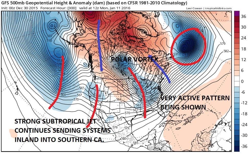
Now we are at day 12 which is the second weekend of January. The polar vortex in the arctic is gone and a new one is set up over Hudson Bay. The subtropical jet is working overtime sending one system after another crashing into Southern California. The game going forward if this is correct is how the two jets interact when they attempt to come together when they near the east coast. That will of course be a short term issue.
Granted that all of this is going to change in terms of the specifics, however the takeaway here is that pattern change is here. Colder air will return to the east, and there will be an active southern stream sending weather systems toward the east coast. Storm signals were given off yesterday by the European as well as the ensembles. We will see if the those storm signals are confirmed by the other overnight model runs. The confidence level here in the forecast is cautious but increasing daily.
NATIONAL WEATHER SERVICE SNOW FORECASTS
LATEST JOESTRADAMUS ON THE LONG RANGE
Weather App

Winter is coming. Don’t be without Meteorologist Joe Cioffi’s weather app. It is a complete weather app to suit your forecast needs. All the weather information you need is right on your phone. Android or I-phone, use it to keep track of all the latest weather information and forecasts. This weather app is also free of advertising so you don’t have to worry about security issues with your device. An accurate forecast and no worries that your device is being compromised.
Use it in conjunction with my website and my facebook and twitterand you have complete weather coverage of all the latest weather and the long range outlook. The website has been redone and upgraded. Its easy to use and everything is archived so you can see how well Joe does or doesn’t do when it comes to forecasts and outlooks.
Just click on the google play button or the apple store button on the sidebar for my app which is onMy Weather Concierge. Download the app for free. Subscribe to my forecasts on an ad free environment for just 99 cents a month.
Get my forecasts in the palm of your hand for less than the cost of a cup of Joe!

![]()