Storm Departing Weather Improves Next 2 Days
Our mostly rain system performed rather well today tracking close to model expectations for rain amounts of 1 to 2 inches in some areas. We still have a little more work today before weather conditions generally improve. We still have some back edge issues to work through this evening but skies should clear out overnight for most from NYC south and west and later tonight for Southern New England and Long Island east as the low moves into the Gulf of Maine.
SATELLITE

REGIONAL RADAR

Regional radar shows the rain shifting into New England and in the colder air across Northeast NY, Northern Vermont, New Hampshire & Maine we have rain downstate in both cases and snow in the northern halves with various warnings and advisories up. Local radars for NYC & PHL show some leftover patches of precipitation. Earlier some wet snow was in the mix in areas across Eastern Pennsylvania but that is long over with. Temperatures by morning will bottom out in the 30s.
LOCAL RADAR NEW YORK CITY

LOCAL RADAR PHILADELPHIA


On to the week ahead which will bring some sunshine and rather decent temperatures around here for a change. Monday’s highs will reach into the 50s in most places by afternoon and it should be in the 50s everywhere on Tuesday.
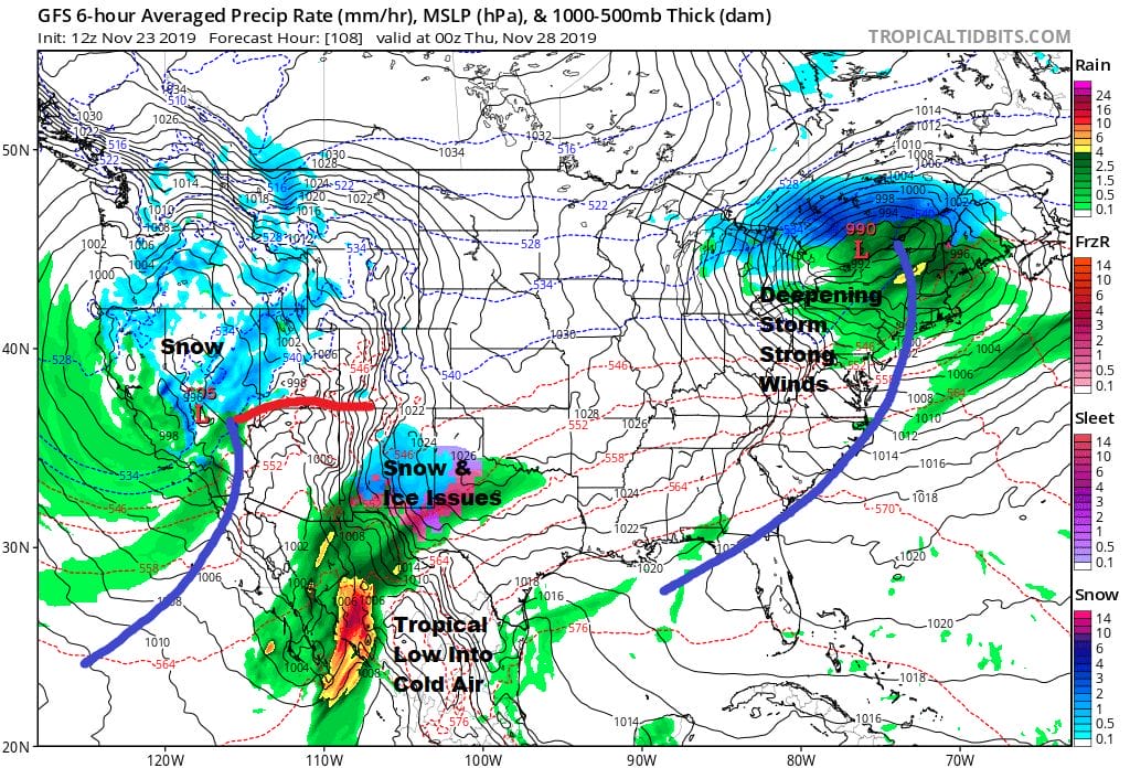
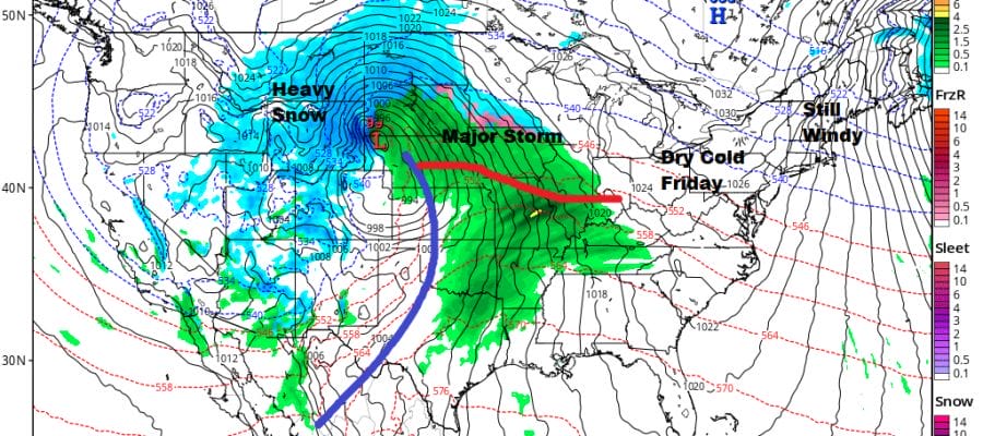
There are no important changes in the outlook for Wednesday as a developing new storm in Colorado heads for the Great Lakes and strengthens once it passes across Northern New England. We could se a few scattered showers with this as a cold front passes late Wednesday afternoon. Highs will be in the upper 50s to lower 60s. Then it is all about gusty winds Wednesday night and Thursday Thanksgiving Day. Sustained winds of 15 to 25 mph with higher gusts are forecast all day but we will have sunshine with highs just in the 40s.
 Friday looks good with sunshine but it will be cold as high pressure builds down from Eastern Canada and Wednesday’s storm system parks itself near Newfoundland for a few days. Next weekend we will likely deal with the storm in the Central Plains/Rockies in some fashion though there is uncertainty regarding timing and track thanks to the blocking low to the east. We won’t know much more for another couple of days as models deal with the blocking pattern and how long it holds.
BE SURE TO DOWNLOAD THE FREE METEOROLOGIST JOE CIOFFI WEATHER APP &
ANGRY BEN’S FREE WEATHER APP “THE ANGRY WEATHERMAN!
MANY THANKS TO TROPICAL TIDBITS FOR THE USE OF MAPS
Please note that with regards to any severe weather, tropical storms, or hurricanes, should a storm be threatening, please consult your local National Weather Service office or your local government officials about what action you should be taking to protect life and property.


