
Spring Blocking Long Range

MENTION JOE CIOFFI AND GET A 5% DISCOUNT
Spring Blocking Long Range is what the models are showing for the next week. This is a signature of most springs. The jet stream is pulling up northward and lots of stray energy gets left behind trapped in more southern latitudes. The result is either a prolonged period of nice weather or a prolonged period of gray nasty weather. We may be in store for the latter.
The Euro model leads the way in all this. Once the cold front that is coming for Tuesday moves on through the entire upper air pattern begins to swing into blocking mode.
Spring Blocking Long Range Euro Model Wednesday April 13, 2016


Above we have the Euro model surface and upper air for Wednesday of this week. The strong ridge in the Atlantic will force the next weather system to drop southward and “cut off” from the main band of upper air winds. This will cause a wave to develop on the front and move northeast. However that wave becomes trapped offshore and will be forced to rotate back westward. The strong onshore flow will bring moisture inland from the east with occasional periods of rain. Add to that a raw northeast wind, and the outcome will be a multi-day stretch of gloomy gray skies with occasional periods of rain or just drizzle. This is the kind of weather spring is known for in the northeast.
Spring Blocking Long Range Euro Model Friday April 15th 2016

The polar jet is so far north now that it really is of no influence at all in the long term equation. As long as it stays separated it can’t move these weather systems along in a normal west to east fashion. Also this not one but 3 weather systems locked up in the flow. The biggest is the one in the far eastern Atlantic. Until something comes along to break it down, we remain locked in.
Spring Blocking Long Range Euro Model Surface Map Friday April 15, 2016
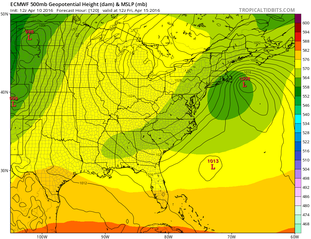
The surface map at the end of the week on the Euro model shows the same wave offshore the New England coast. The onshore flow is completely in control with the strong high to the north. The gradient here is pretty tight especially in Southeastern New England. The persistent onshore flow will probably create some tidal flooding issues along our coastline later this coming week and into next weekend.
FiOS1 News Weather Forecast For Long Island
FiOS1 News Weather Forecast For New Jersey
FiOS1 News Weather Forecast For Hudson Valley
NATIONAL WEATHER SERVICE SNOW FORECASTS
LATEST JOESTRADAMUS ON THE LONG RANGE

NOMINATED FOR AN APPY AWARD FOR BEST WEATHER APP!!
Weather App

Don’t be without Meteorologist Joe Cioffi’s weather app. It is really a meteorologist app because you get my forecasts and my analysis and not some automated computer generated forecast based on the GFS model. This is why your app forecast changes every 6 hours. It is model driven with no human input at all. It gives you an icon, a temperature and no insight whatsoever.
It is a complete weather app to suit your forecast needs. All the weather information you need is right on your phone. Android or I-phone, use it to keep track of all the latest weather information and forecasts. This weather app is also free of advertising so you don’t have to worry about security issues with your device. An accurate forecast and no worries that your device is being compromised.
Use it in conjunction with my website and my facebook and twitter and you have complete weather coverage of all the latest weather and the long range outlook. The website has been redone and upgraded. Its easy to use and everything is archived so you can see how well Joe does or doesn’t do when it comes to forecasts and outlooks.
Just click on the google play button or the apple store button on the sidebar for my app which is on My Weather Concierge. Download the app for free. Subscribe to my forecasts on an ad free environment for just 99 cents a month.
Get my forecasts in the palm of your hand for less than the cost of a cup of Joe!
![]()

