
Spring Arrives Early
![]()
Once we get past this weekend things are happening in the atmosphere that will mean spring arrives early. Usually spring weather means onshore flow, lots of clouds, and grey rainy conditions. This time however we are in for a nice stretch of weather beginning on Monday and last I believe into Thursday. The upper air jet stream pattern is going to now switch back to the west as the center of action.
Spring Arrives Early Monday Upper Air
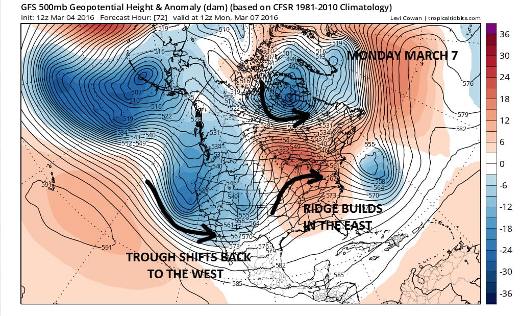
The pattern is not that different from what we saw in December with a ridge taking shape in the Eastern States. This time of year the ridge needs to be strong enough to prevent any backdoor cold fronts from coming through. It appears on all models that this is the case through at least Wednesday and the European would extend that into part of Thursday.
Spring Arrives Early Wednesday Upper Air

Another element of spring of course is severe weather. By midweek a strong upper air disturbance gets ejected from the Pacific into Texas. There is a strong upper air storm that moves into West Texas by late Wednesday. This opens the door for severe weather for the lower Mississippi Valley and parts of Texas.
Spring Arrives Early Wednesday Surface Map
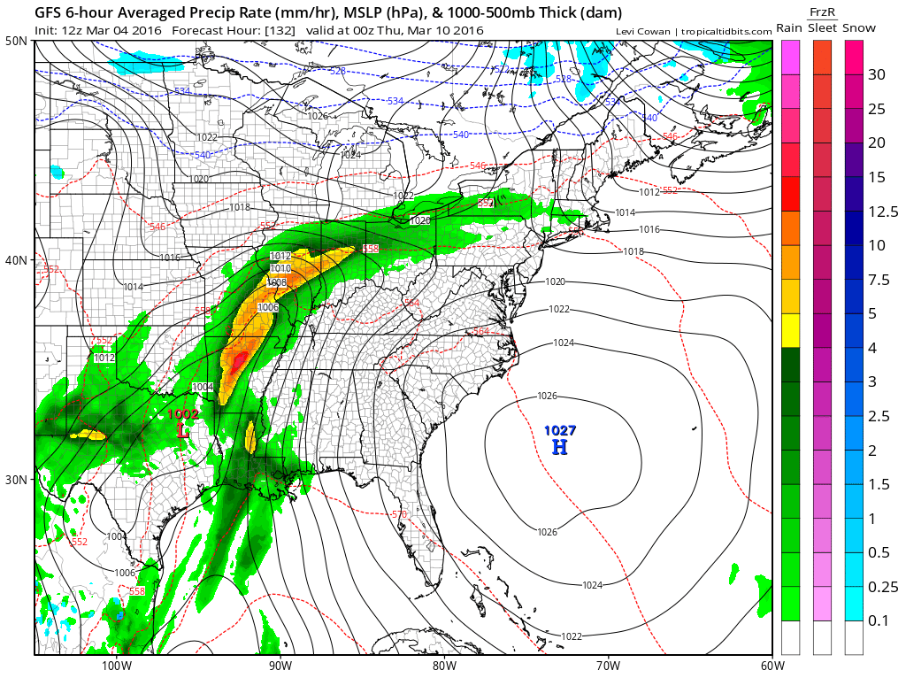
You can see the edge of a cold front getting close to us Wednesday night from the northwest. The European is slower with this front and delays it until Thursday. These fronts can be hard to time in the long range but we think we are warm at least through Wednesday. Also warm ups this time of year tend to be underdone by temperature models. With the strong March sun and a mostly west or west southwest wind, temperatures wind up being higher than modeled.
Spring Arrives Early Temperature Forecast Wednesday
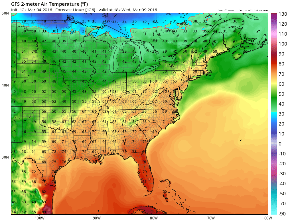
The GFS is showing mid to upper 60s for Wednesday. I think we might see this as early as Tuesday and that the numbers shown above could be too low by at least 5 degrees. Low to mid 70s on Wednesday seems to be a strong possibility.
FiOS1 News Weather Forecast For Long Island
FiOS1 News Weather Forecast For New Jersey
FiOS1 News Weather Forecast For Hudson Valley
NATIONAL WEATHER SERVICE SNOW FORECASTS
LATEST JOESTRADAMUS ON THE LONG RANGE
Weather App

Don’t be without Meteorologist Joe Cioffi’s weather app. It is really a meteorologist app because you get my forecasts and my analysis and not some automated computer generated forecast based on the GFS model. This is why your app forecast changes every 6 hours. It is model driven with no human input at all. It gives you an icon, a temperature and no insight whatsoever.
It is a complete weather app to suit your forecast needs. All the weather information you need is right on your phone. Android or I-phone, use it to keep track of all the latest weather information and forecasts. This weather app is also free of advertising so you don’t have to worry about security issues with your device. An accurate forecast and no worries that your device is being compromised.
Use it in conjunction with my website and my facebook and twitter and you have complete weather coverage of all the latest weather and the long range outlook. The website has been redone and upgraded. Its easy to use and everything is archived so you can see how well Joe does or doesn’t do when it comes to forecasts and outlooks.
Just click on the google play button or the apple store button on the sidebar for my app which is on My Weather Concierge. Download the app for free. Subscribe to my forecasts on an ad free environment for just 99 cents a month.
Get my forecasts in the palm of your hand for less than the cost of a cup of Joe!
![]()
