Soaking Rain Today Tonight Brief Change To Snow Before Ending Inland
Spring Begins Saturday

Weather in 5/Joe & Joe Weather Show Latest Podcast
Soaking Rain Today Tonight Brief Change To Snow Before Ending Inland
Spring Begins Saturday
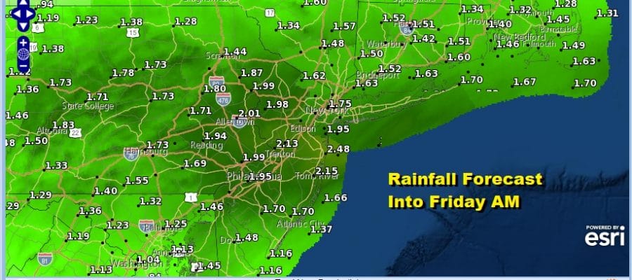
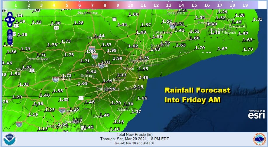
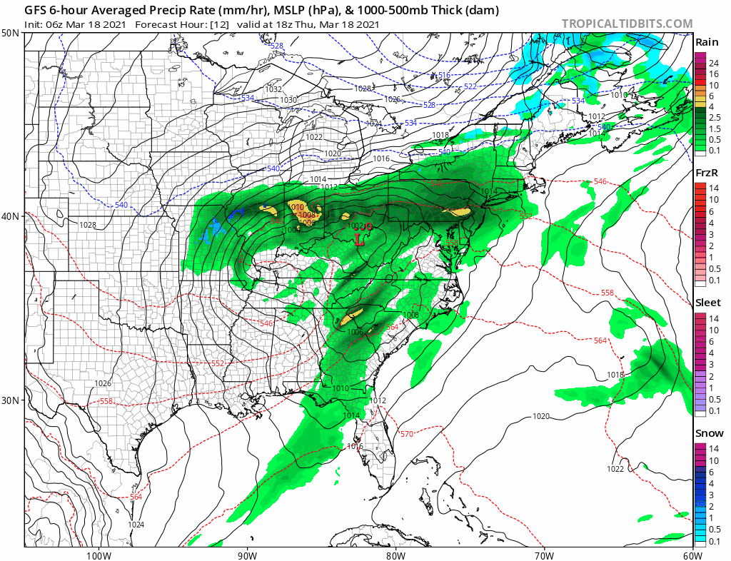
It has been nearly 4 weeks since we have seen anything close to a soaking rain. That dry streak ends today as low pressure moves across the Lower Ohio Valley today and exits the Virginia coast later tonight. That puts us in line for an east to southeast wind and a solid soaking rain. Most areas will average about 1.25 to 1.75 inches of rain but some amounts locally could go higher.
During tonight cold air comes down from the north as the low passes offshore which could mean a change over to a mix of snow for a few hours before ending. I have not been impressed by this possibility for the last several days and I remain unimpressed.
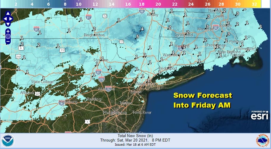
The issue here is that the system reaches peak intensity today and the upper features actually weaken as they move east. If it was at least maintaining its strength or strengthening as it was making its exit, then we could make a case for accumulating snows. The opposite is true here and the snow forecast above shows that even in areas to the north where you do see a change, we are talking at most a coating to a few inches and for that you will have to go to elevated areas north of Route 84.
SATELLITE

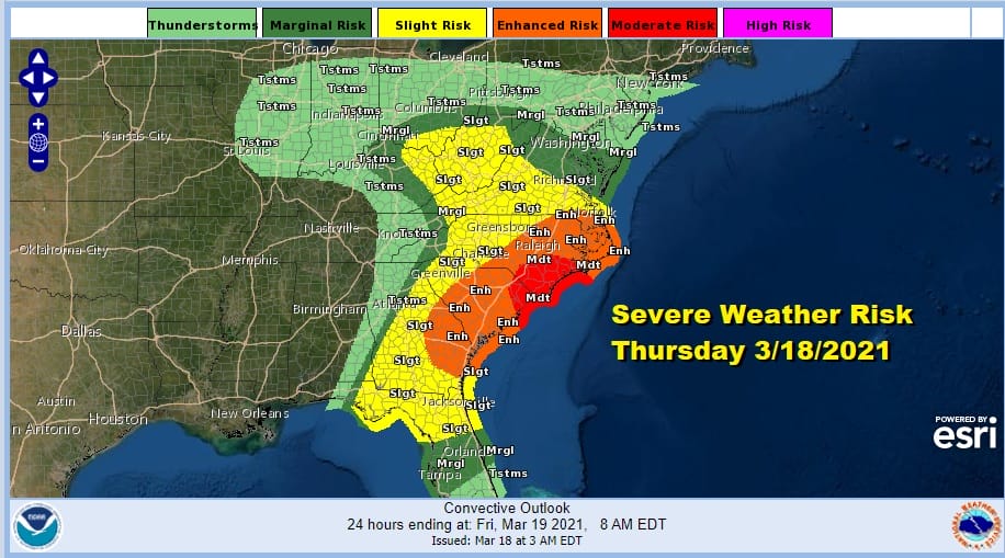
Radars are loading up quickly in the Northeast and Middle Atlantic states. This will be another day for severe weather. Today it shifts to the Southeast US from Virginia to Florida and west to the Central and Southern Appalachians.
F5 WEATHER RADARS


The Storm Prediction Center has reduced the geographic size of the risk area today but it mains an enhanced to moderate risk over a large area from Georgia to Virginia. Severe weather swept across the Gulf States yesterday with numerous tornadoes. Friday severe weather takes a breather across the US.
Back to our weather for Friday, weather conditions improve on a gusty north northeast winds at 20 to 30 mph. It should remain below wind advisory criteria. Look for sunshine to develop. Highs will be just into the 40s and then skies clear out Friday night with lows mostly in the 20s to near 30.
Saturday we should see sunshine with less wind. Highs will be in the upper 40s and lower 50s. Sunday we will see some sun and clouds with most highs in the 50s. The high moves out to the east of Cape Cod which doesn’t put it in a position for a solid warm up next week. The issue will be an ocean wind and an onshore flow. This will likely keep temperatures in check. Monday’s highs will be in the 50s to near 60 with warmer temperatures inland and cooler temperatures along the coast. Also we will have cloud issues along the coast that will hold temperatures down. We could see temperatures inch a little higher on Tuesday with clouds around. Highs in the upper 50s to lower 60s. No rain is forecast until later next week when another storm system and cold front brings rain here perhaps next Thursday.
BE SURE TO DOWNLOAD THE FREE METEOROLOGIST JOE CIOFFI WEATHER APP &
ANGRY BEN’S FREE WEATHER APP “THE ANGRY WEATHERMAN!

MANY THANKS TO TROPICAL TIDBITS & F5 WEATHER FOR THE USE OF MAPS
Please note that with regards to any severe weather, tropical storms, or hurricanes, should a storm be threatening, please consult your local National Weather Service office or your local government officials about what action you should be taking to protect life and property.


