Snow Tonight into Saturday Followed By High Winds
Extreme Cold Into Sunday
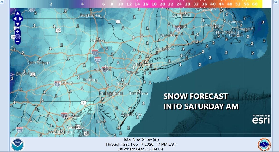
The weekend is upon us and we are getting ready for what is probably going to be the coldest shot of air for the winter season and that is saying a lot considering that we have seen so many shots of very cold to bitter air. We will see snow tonight into Saturday morning and we are forecasting a general coating to a couple of inches with the highest amounts over Suffolk County on Long Island as well as Southeastern Connecticut east to Rhode Island.
Ahead of this today an arctic front is approaching. You can see a storm system to the east of the Carolinas heading eastward while the arctic boundary is apparent on the satellite loop and radars to the northwest. Clouds will be increasing today and temperatures will only top out in the upper 20s to around 30 degrees. Snow will develop tonight sometime between 8pm and 11pm from west to east.
SATELLITE WITH LIGHTNING STRIKES
WEATHER RADAR
Along with the arctic front, we have another developing storm tonight offshore southeast of New Jersey. This storm system is not really a factor though to could enhance the snowfall a bit Saturday morning in coastal areas. Either way the snow will end from west to east between 7am and 10am and then in comes the arctic air on very strong northwest winds that will gust to over 40 mph at times, and some coastal areas of New Jersey will gust to over 50 mph.
The story Saturday after the snow is done will be the falling temperatures and the wicked wind chills that will be developing. We will bottom out Saturday morning in the mid teens to low 20s but the real bottom doesn’t come until Sunday morning. Temperatures Saturday will be falling all day and by evening, the warmest urban and coastal areas will be hovering just over 10 degrees and inland areas will be down in the single digits.
Strong winds will continue Saturday night under mainly clear skies. By Sunday morning we will see lows down in the low to mid single digits along the coast and in the warmest urban locations. Inland lows will be below zero in many areas and wind chills overnight into Sunday morning will continue to be in double digits below zero. This is likely to be the coldest arctic shot of the winter season.
Sunday we will see winds come off the highs will it will still be on the windy side at times especially in the morning. We will see sunshine Sunday but high temperatures likely will not get out of the teens in most places. Another very cold night is setting up for Sunday night into Monday morning with lows in the single digits to below zero inland. Monday we should start to recover with sunshine and highs in the 20s.
BE SURE TO DOWNLOAD THE FREE METEOROLOGIST JOE CIOFFI WEATHER APP &
ANGRY BEN’S FREE WEATHER APP “THE ANGRY WEATHERMAN!
MANY THANKS TO TROPICAL TIDBITS FOR THE USE OF MAPS
Please note that with regards to any severe weather, tropical storms, or hurricanes, should a storm be threatening, please consult your local National Weather Service office or your local government officials about what action you should be taking to protect life and property.