Snow Threats Next Week Weather Models Bullish

Snow Threats Next Week Weather Models Bullish
We have the atmosphere undergoing some changes next week and anytime we see big moves in pressure patterns across North America, the atmopshere gets a headache that needs relieve. Such a change will be occurring next week as the teleconnection indices indicate.
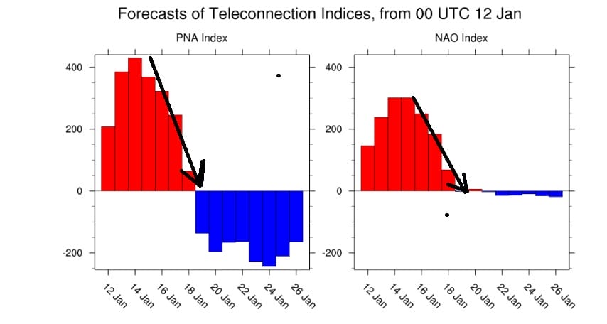
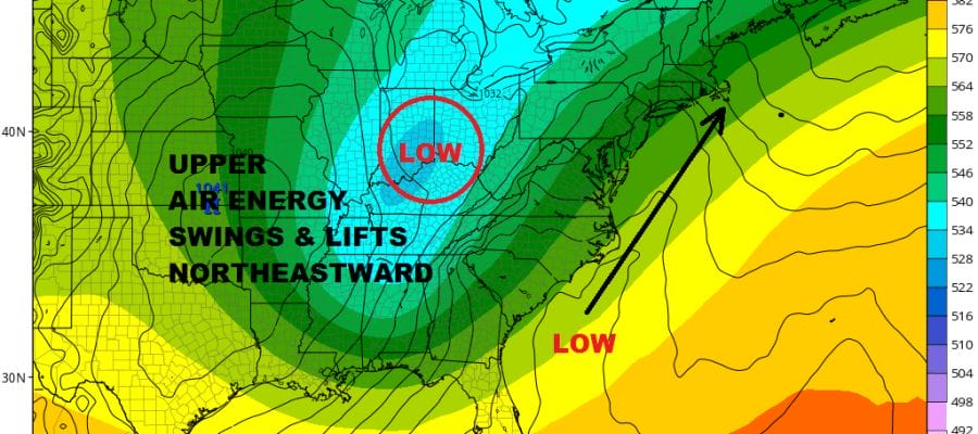
Two of the indices we watch are making big changes. The North Atlantic Oscillation is crashing from strong positive to neutral by the middle of next week. This is combined with the Pacific North America Pattern index crashing from off the wall positive to neutral. This is the view at least from the weather model ensembles. The point where both these indices get to neutral is around the dates that are vunerable putting the time frame at the middle of next week. The NAO crashing would favor a coastal or offshore track however the weakening ridge in the west is going to probably be the bigger player here. The GFS and European have 2 different looks in the west that will impact storm development in the Eastern US.
GFS JET STREAM WEDNESDAY JANUARY 18 2018
EUROPEAN JET STREAM WEDNESDAY JANUARY 18 2018

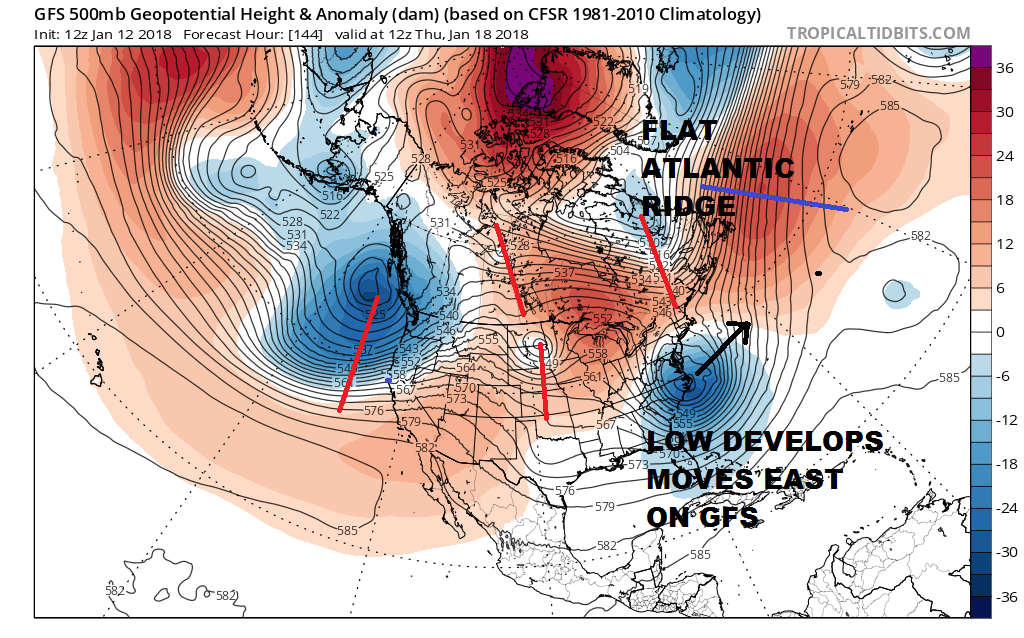
Both weather models attempt to develop a storm off the Carolina coast Wednesday but the models differ on the structure of the jet stream across North America. The two important differences are in the west where the European maintains a strong ridge in the west and holds the trough off the west coast offshore. The GFS crashes that system into the west faster which flattens the ridging in Western Canada. Also in the East there is a system swinging southeast in Labrador which the GFS uses to suppress the system off the East Coast. The European on the other hand is weaker and west with that system and it actually helps to lift the system northward along the east coast.
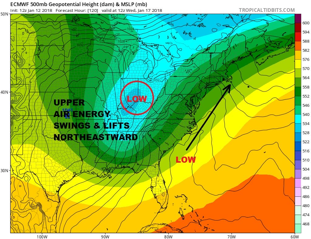
Before this happens energy does move across the Great Lakes and into the Northeast on Tuesday with a weaker system. This will produce some snow later Tuesday and Tuesday night. This looks to be a light event. Models are producing a few inches with the Tuesday system. The European does as well and produces a heavy snowfall for Wednesday night and Thursday as well. Obviously we have something to watch as the active winter of 2018 continues with more surprises probably ahead of us.
MANY THANKS TO TROPICAL TIDBITS FOR THE WONDERFUL USE OF THE MAPS

GET JOE A CIGAR IF YOU LIKE!
FiOS1 News Weather Forecast For Long Island
FiOS1 News Weather Forecast For New Jersey
FiOS1 News Weather Forecast For Hudson Valley
NATIONAL WEATHER SERVICE SNOW FORECASTS
LATEST JOESTRADAMUS ON THE LONG RANGE
Weather App

Don’t be without Meteorologist Joe Cioffi’s weather app. It is really a meteorologist app because you get my forecasts and my analysis and not some automated computer generated forecast based on the GFS model. This is why your app forecast changes every 6 hours. It is model driven with no human input at all. It gives you an icon, a temperature and no insight whatsoever.
It is a complete weather app to suit your forecast needs. All the weather information you need is right on your phone. Android or I-phone, use it to keep track of all the latest weather information and forecasts. This weather app is also free of advertising so you don’t have to worry about security issues with your device. An accurate forecast and no worries that your device is being compromised.
Use it in conjunction with my website and my facebook and twitter and you have complete weather coverage of all the latest weather and the long range outlook. The website has been redone and upgraded. Its easy to use and everything is archived so you can see how well Joe does or doesn’t do when it comes to forecasts and outlooks.
Just click on the google play button or the apple store button on the sidebar for my app which is on My Weather Concierge. Download the app for free. Subscribe to my forecasts on an ad free environment for just 99 cents a month.
Get my forecasts in the palm of your hand for less than the cost of a cup of Joe!