Snow Threats Going Forward

Snow Threats Going Forward
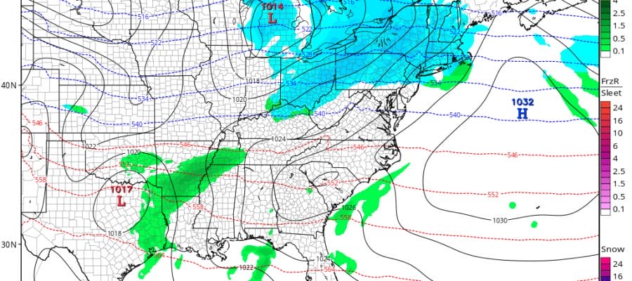
Earlier today JOESTRADAMUS and ANGRY BEN talked about the cold air that is coming in the long range. That seems to be what all the models agree on at this point. What they don’t agree on is what if any snow threats are lying ahead and how all of this plays out. We have seen 3 minor events effect inland areas over the last 2 weeks. It has been my experience that weather systems in winters while not exact tend to rhyme to some degree. I would not necessarily conclude from those first 3 minor events that the winter will continue this way. It is not unusual to see early season events effect inland areas more than the coast. This has happened early in prior winters only to see storm tracks shift southward as we get deeper into the winter months. With all that said lets see what like ahead of us.

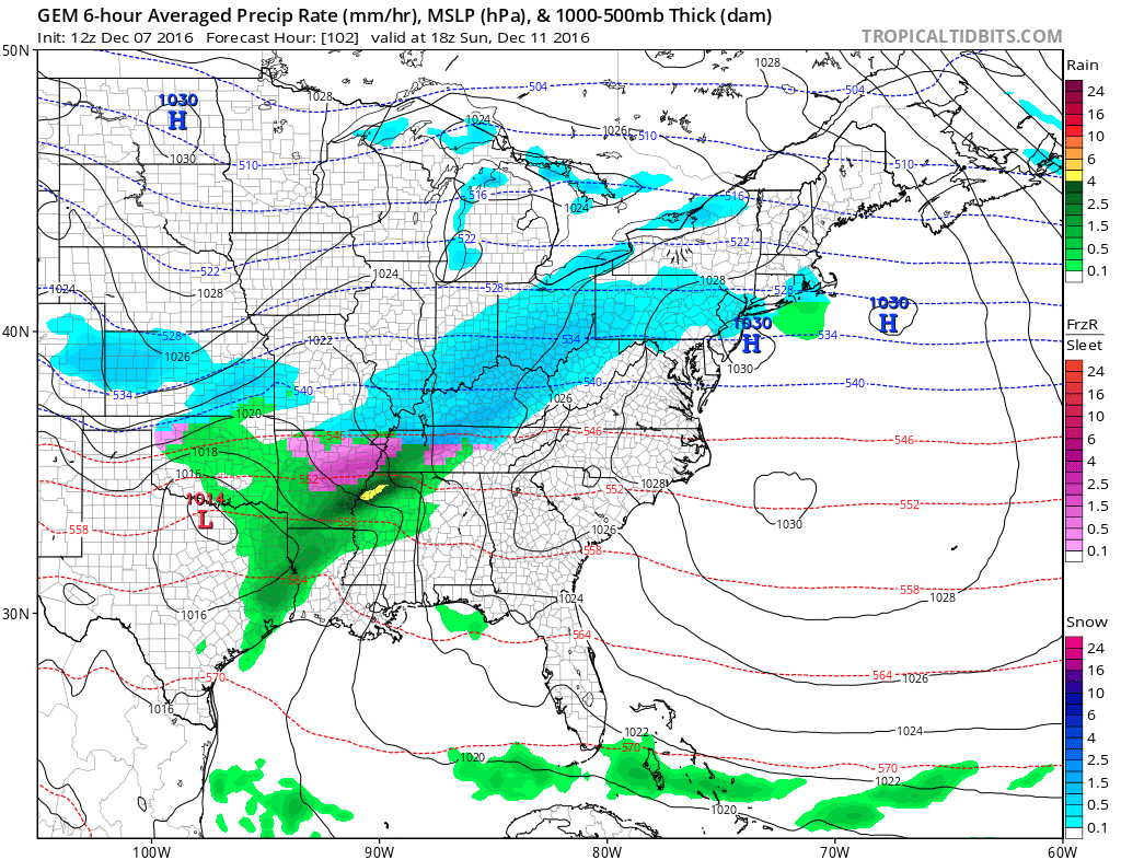
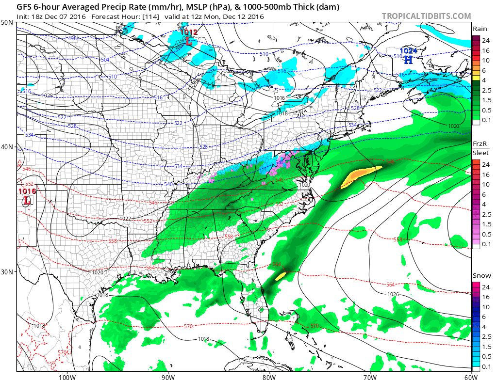
The GFS late this afternoon and the Canadian model run from earlier are not that far off. Both show a weakening low heading into the Great Lakes with a wave on the southern end of a cold front. Now if the GFS is correct there would be a warm front to the south and an area of snow ahead of it. The GFS generates a coating to a inch or so from this. Then both models take a wave on the cold front to the south and move it northeast for another round of precipitation. The GFS keeps the wave weak while the Canadian has a stronger low with significant snow from it for early next week.

The European on the other hand brings one strong wave out of the plains and takes a deepening low across the lower lakes and to Western NY creating a rain storm for much of the east.
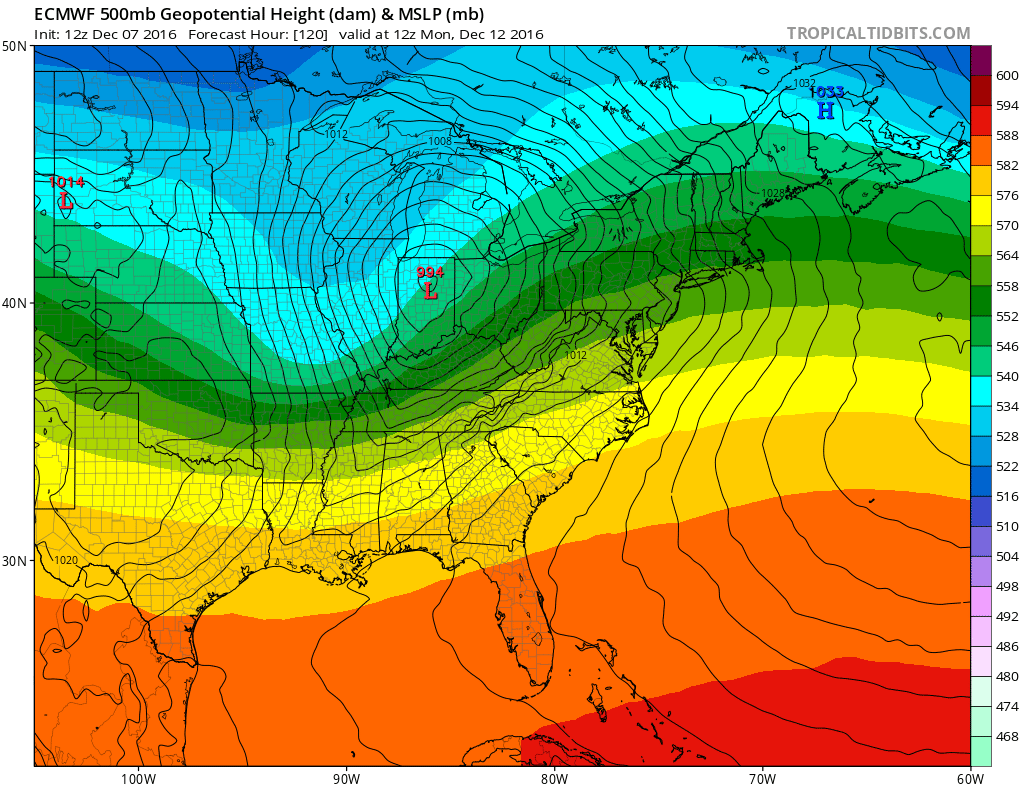

The reason why the European does this is because it brings out one strong system out of the west while the other 2 models are faster and weaker with those systems. Given the European’s reason terrible performance in making big storms that did not happen, and given that the European model has been badly handling systems coming out of the west in the last 2 weeks, it would seem to be a bet against. No doubt models have been highly volatile lately flipping back and forth in all directions, for now we will lean to the weaker solutions of the other models. Needless to say confidence level on this is very low at this point. The GFS model has overall performed better than the other models in general so it would carry heavier weight at this point. For now I am waiting for the NAM model to come into time range to see where it goes with all of this. At this point through Sunday morning it seems to line up better with the GFS than with the other models in showing the warm front setting up to our south and west.

Beyond Monday the GFS model has several threats in between arctic air masses that come down but specifics shown by the model seem to be a waste in energy putting any stock in them given the continued weather model volatility. It would seem that with all this cold air coming down that something is going to try to happen somewhere. But the hows and whys remain a big question.
For more on the cold weather JOESTRADAMUS has his latest post while ANGRY BEN focuses on the long range and how it will effect New York City.
MANY THANKS TO TROPICAL TIDBITS FOR THE WONDERFUL USE OF THE MAPS
SNOW REMOVAL COMPANIES FOR YOUR WINTER NEEDS
LONG ISLAND ROCKLAND COUNTY Connecticut

![]()


JOHNSTOWN PA
COLOSIMO LAWNCARE

FiOS1 News Weather Forecast For Long Island
FiOS1 News Weather Forecast For New Jersey
FiOS1 News Weather Forecast For Hudson Valley
NATIONAL WEATHER SERVICE SNOW FORECASTS
Weather App

Don’t be without Meteorologist Joe Cioffi’s weather app. It is really a meteorologist app because you get my forecasts and my analysis and not some automated computer generated forecast based on the GFS model. This is why your app forecast changes every 6 hours. It is model driven with no human input at all. It gives you an icon, a temperature and no insight whatsoever.
It is a complete weather app to suit your forecast needs. All the weather information you need is right on your phone. Android or I-phone, use it to keep track of all the latest weather information and forecasts. This weather app is also free of advertising so you don’t have to worry about security issues with your device. An accurate forecast and no worries that your device is being compromised.
Use it in conjunction with my website and my facebook and twitter and you have complete weather coverage of all the latest weather and the long range outlook. The website has been redone and upgraded. Its easy to use and everything is archived so you can see how well Joe does or doesn’t do when it comes to forecasts and outlooks.
Just click on the google play button or the apple store button on the sidebar for my app which is on My Weather Concierge. Download the app for free. Subscribe to my forecasts on an ad free environment for just 99 cents a month.
Get my forecasts in the palm of your hand for less than the cost of a cup of Joe!
![]()
