Snow Rain Showers Tonight Strong Storm
Windswept Rain Late Christmas Eve Sharply Colder Christmas Day

Weather in 5/Joe & Joe Weather Show Latest Podcast
Snow Rain Showers Tonight Strong Storm
Windswept Rain Late Christmas Eve Sharply Colder Christmas Day
The new week begins and we have another weak upper air disturbance and cold front that will be moving though tonight into Tuesday morning. Before we go there we have today and overnight some areas away from warmer urban centers are seeing fog and temperatures close to or just barely below freezing so watch for some black ice in areas mainly away from the metro urban centers. Otherwise we are seeing clouds on the sateliite picture and that will be the signature today. However there should be some sun in the mix as well. Temperatures today should reach the upper 30s and lower 40s in most places.
SATELLITE

On the radar this morning we are not seeing much happening here from the standpoint of precipitation and we should see a quiet radar today though activity will start to develop tonight to the west across Pennsylvania and eventually head our way overnight.
The upper trough and corresponding low and cold front will just move along. The trough is not hooking up with any southern stream system as that went by yesterday and another forms tonight well to the east. There will be an area of snow and rain with the system and we include that in our forecast.

I’m not looking at this amounting to much accumulation wise. There is an outside chance that some colder spots and elevated areas that see snow rather than rain could get a quick coating to an inch of accumulation. For most this should be a non event. Temperatures overnight will bottom in the upper 20s to lower 30s. Tuesday looks like a sunny breezy day with highs in the upper 30s and lower 40s. Wednesday will be sunny and cold with highs in the upper 30s to near 40.
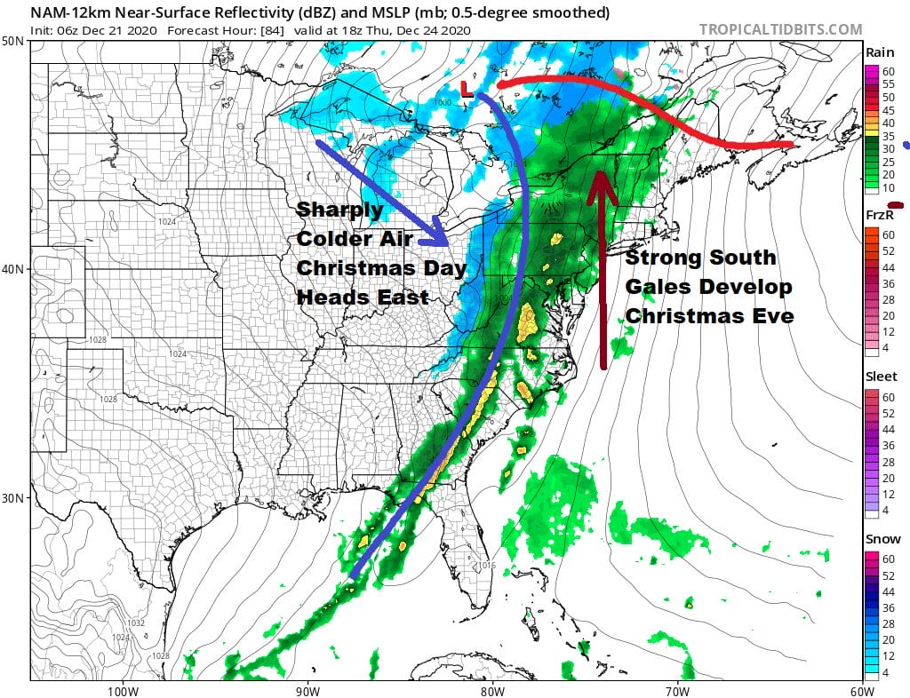
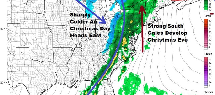
Sometimes you can have the tele-connections in favor of winter weather but not all winter weather means snow and not all patterns set up the same way each time. This time around we have a low that is moving across the Northern Plains to north of the Great Lakes by Christmas Eve with a trailing strong cold front. We have a dynamic upper air pattern with a deep trough. A strong high to the east is going to create a very tight gradient and that means southerly gales will develop along the coast Thursday. There will be heavy rain and perhaps even a thunderstorm or two when this front passes Thursday night.

It appears that showers arrive from west to east late morning or afternoon Christmas Eve and then it is done from west to east around midnight or shortly before or after. There is cold air that looks to come in quickly behind it. We will be in the 50s to near 60 ahead of the front and then fall to the mid 20s to lower 30s by Friday Christmas morning. The models are suggesting that there could be a very short change to sleet and wet snow after the front passing lasting no more than an hour or two. Most times in cases like this the rain simply shuts off. The fast arrival of cold air brings up the question of a quick freeze and a bit of icing. We will address this issue on Wednesday when we are close enough to see the hourly details. We will go from a strong south wind to a screaming northwest wind Thursday night into Friday and a wind advisory possibility exists both ahead and behind the front. Christmas Day will be windy and very as temperatures settle into the upper 20s and mid 30s. The weekend looks to be dry for Saturday and most of Sunday as another cold front approaches for Sunday night and Monday.
BE SURE TO DOWNLOAD THE FREE METEOROLOGIST JOE CIOFFI WEATHER APP &
ANGRY BEN’S FREE WEATHER APP “THE ANGRY WEATHERMAN!
MANY THANKS TO TROPICAL TIDBITS FOR THE USE OF MAPS
Please note that with regards to any severe weather, tropical storms, or hurricanes, should a storm be threatening, please consult your local National Weather Service office or your local government officials about what action you should be taking to protect life and property.


