Snow Inland Mix Precip And Rain Coast Very Cold Ahead of Stronger Winter Storm Wednesday

Weather in 5/Joe & Joe Weather Show Latest Podcast
Snow Inland Mix Precip And Rain Coast Very Cold Ahead of Stronger Winter Storm Wednesday
After a sunny day and temperatures that reached the 60s in some areas it is hard to imagine we have snow in the forecast but we do. Monday’s weather system is the weaker of the two but it is key to the arrival of very cold air and that sets the table for a winter storm later Wednesday into Thursday morning. There are some clouds around this evening and more clouds are to the west. They will gradually increase overnight. The wind will begin to turn to the north and temperatures will slowly drop to the upper 30s and lower 40s by morning. No precipitation is expected overnight.
SATELLITE

REGIONAL RADAR

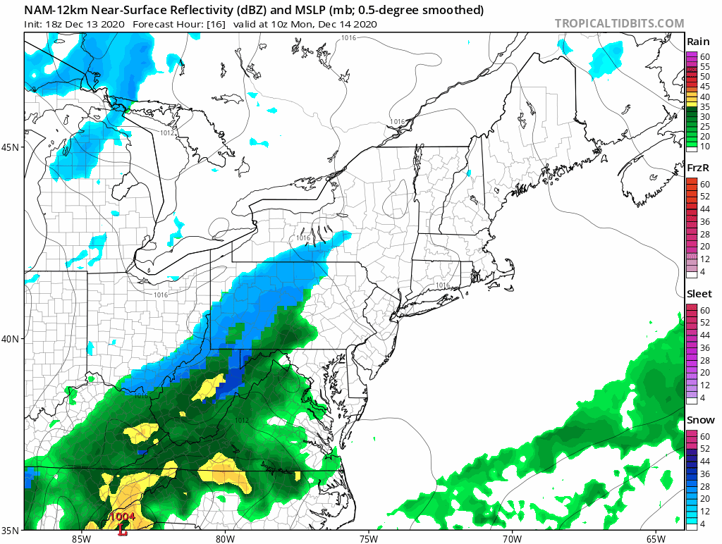
Low pressure is moving from the Southern Plains to the Carolinas tonight into Monday and an area of rain will bulge northward by morning. Snow will develop on the northern flank of this low and gradually as we move through the morning and into the afternoon, that snow spreads across Southern and Eastern Pennsylvania. Then that snow heads into Northeastern Pennsylvania and Northern New Jersey and then finally into the Hudson Valley and Connecticut.
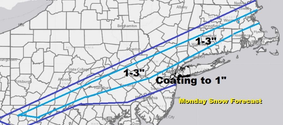
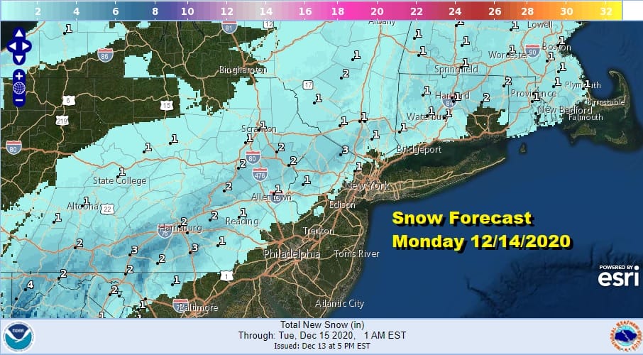
Temperatures Monday will ease through the 30s and into the low 30s north and west of the coast. This is the area that has the best chance for accumulation. The NWS forecast is for a coating to a couple of inches in the areas that are mostly snow and I’m thinking that accumulations will be favored on colder surfaces vs the roads.
Precipitation amounts will be in the half to 3/4 of an inch rain and it will all last about 6 hours. I think that some of the colder air aloft will cool down to the surface and that should create a mix. I’m covering for the possibility that coastal areas of Long Island down to Monmouth County in NJ could see some wet snow in the mix with an outside chance for a coating to an inch of slushy accumulations, mainly on colder surfaces.

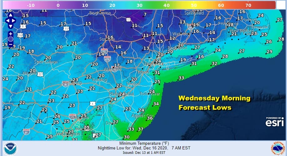
This will end during the afternoon from west to east and skies will clear Monday night. It will be windy and cold with lows by Tuesday morning in the 20s to near 30. Tuesday will be sunny breezy and cold with highs just in the 30s. Then get set for a very cold night Tuesday night into Wednesday morning with mainly clear skies though some clouds will arrive by sunup especially to the south.
The big high to the north bleeds down cold air on Wednesday as clouds increase. Most highs will reach just the upper 20s to lower 30s though it may be warmer in areas to the south like Coastal and Southern New Jersey where it could reach the mid to upper 30s. Precipitation from a second stronger low starts to push into the cold air. It should reach Philadelphia by afternoon and NYC by late afternoon and evening.

It will all be about the battle between the high to the north and the strong low to the south pushing into that cold air. The NAM model above takes us into Thursday morning 1am so there is still more to go here as the snow will probably last until early or mid morning before ending. This storm has the potential to produce 6 inches or more through much of the area. Temperatures will be key. Also will snow mix with sleet on Long Island is another question. For the Jersey shore it will start as sleet and rain and then change to snow sometime overnight into Tuesday morning. We will evaluate weather models overnight and begin to focus our attention on the second storm later Monday.
See early call snow maps and analysis on my weather platform on Patreon.
BE SURE TO DOWNLOAD THE FREE METEOROLOGIST JOE CIOFFI WEATHER APP &
ANGRY BEN’S FREE WEATHER APP “THE ANGRY WEATHERMAN!
MANY THANKS TO TROPICAL TIDBITS FOR THE USE OF MAPS
Please note that with regards to any severe weather, tropical storms, or hurricanes, should a storm be threatening, please consult your local National Weather Service office or your local government officials about what action you should be taking to protect life and property.


