
Snow & Ice Threat For Interior Northeast Next Week?
Weather models this morning are keying in on a storm that is going to produce big snow & ice in the southwest bringing snow & ice to parts of the interior northeast next week. This is the first weather system this month or for that matter this season to even bring snows to anywhere other than northern Maine. It is hard to believe this could even happen considering that tomorrow Christmas Eve is going to see record high temperatures and possibly all time record highs in some places.
All models show a big high building southward from Southern Canada into the Northeast early next week. Both models show a storm ejecting out from the southwest to the Southern Lakes. However there is one huge difference between the European weather model. The GFS weather model is shown below.
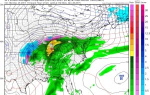
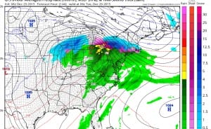
The GFS envelopes the high completely around the storm system which can only get so far north before redeveloping to the east. Also the gfs is a full 24 hours faster than the European weather model which pulls the high out to the east which allows the low to track further north. With the European’s idea snowfall would be much more limited. In fact the European would be dry and actually colder here with nothing happening until dayside Tuesday. The gfs would have precipitation here by Monday afternoon!!!
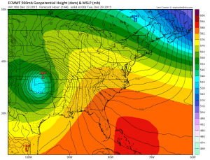
Clearly one of these will be wrong. Timing and speed will be everything and so will the strength of that high to the north. We will defer to later runs to see which model has the right idea. I’m will lean toward the European solution here as it makes more sense, however something has to happen one of these days. Here are the differences in snow outcomes from the 2 models.
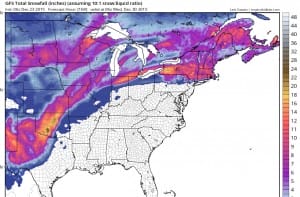
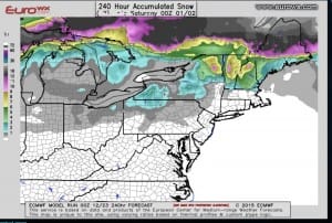
Of course just in principal, take the GFS model snow forecast and cut it half to start off with. We will of course zero in on this over the next few days. One thing about the GFS is has been trending further south with every run as it reacts to the strength of the building high. The European has been consistent with its idea of timing and speed. Snow & ice have to happen eventually somewhere in the northeast.
LATEST JOESTRADAMUS LONG RANGE VIDEO FROM THIS MORNING
LATEST JOESTRADAMUS ON THE LONG RANGE
Weather App

Winter is coming. Don’t be without Meteorologist Joe Cioffi’s weather app. It is a complete weather app to suit your forecast needs. All the weather information you need is right on your phone. Android or I-phone, use it to keep track of all the latest weather information and forecasts. This weather app is also free of advertising so you don’t have to worry about security issues with your device. An accurate forecast and no worries that your device is being compromised.
Use it in conjunction with my website and my facebook and twitterand you have complete weather coverage of all the latest weather and the long range outlook. The website has been redone and upgraded. Its easy to use and everything is archived so you can see how well Joe does or doesn’t do when it comes to forecasts and outlooks.
Just click on the google play button or the apple store button on the sidebar for my app which is onMy Weather Concierge. Download the app for free. Subscribe to my forecasts on an ad free environment for just 99 cents a month.
Get my forecasts in the palm of your hand for less than the cost of a cup of Joe!
