Snow Forecasts Raised Higher Across New Jersey to Southern New England
Snow Forecasts Raised Higher Across New Jersey to
Southern New England

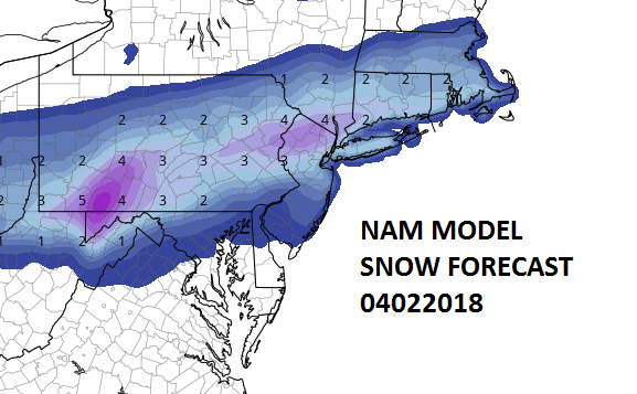
Afternoon weather models didn’t change very much at all during this afternoon. They are showing a fast moving wave off the Delaware coast. This will be a 4 to 6 hour snowfall between 4am and 10am near the coast. Areas in Eastern Pennsylvania westward it will be a 2am-8am event. The NAM positive snow growth map I think has the best idea for snow amounts with many areas seeing several slushy inches. Remember this will all be gone by late in the afternoon Monday as snow melts very fast this time of year.
As far as tonight and Easter Sunday is concerned there are no changes in the forecast. Clouds and a brief shower during the hours before daybreak and then a mostly sunny Easter Sunday with highs in the 50s.

GET JOE A CIGAR SO HE CAN RELAX!
NEW YORK CITY AND VICINITY SNOW

NEW YORK CITY & VICINITY ICE

NEW JERSEY SE PA & VICINITY ICE
NEW JERSEY & PARTS OF NE PA

SOUTHERN AND SOUTHEAST NEW ENGLAND

NORTHERN NEW ENGLAND

WESTERN NEW ENGLAND

MIDDLE AND UPPER HUDSON VALLEY

CENTRAL NEW YORK & NE PA

WESTERN NEW YORK

CENTRAL & SOUTH CENTRAL PA

VIRGINIA & MARYLAND

DAILY NORTHEAST SNOWFALL

Please be advised that these are National Weather Service Forecast Maps and they auto update. Each office may update at different times and some offices are slower to update then others. Maps are usually updated before 5am and & 5pm however they may be updated at other times depending on forecast conditions. These are not my forecasts. My forecasts can be found on the JOE’S SNOWFORECAST PAGE. Individual forecasts for specific areas may also be found when conditions warrant on the my area forecasts. Those can be found on the website menu. Click on forecasts and then select your specific area.