Snow Forecast Sunday March 19 2017

Snow Forecast Sunday March 19 2017
We looked at the overnight weather model series and for the time being we are going to leave last night’s forecast alone. I will go to more specific numbers later today but it seems that for Long Island and Southern Connecticut south of 95 there is a chance for some 6 inch amounts. Springtime systems like this one can surprise and since the bulk of this wet snow is going to fall Saturday night it is likely to stick to all surfaces since the ground ain’t that warm folks following the bitter cold of the last few days.

GET JOE A CIGAR IF YOU LIKE
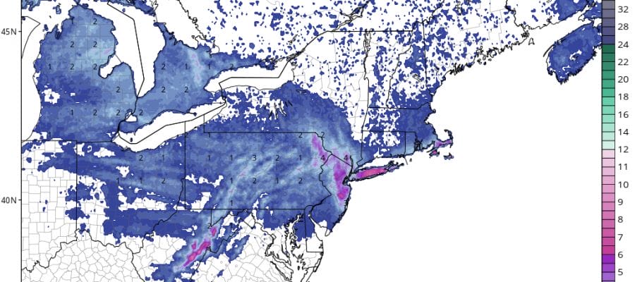
We can begin to see the precipitation from this system moving into the Western Great Lakes and Ohio Valley. Low pressure is moving southeastward from there and will maneuver its way to Eastern Virgniia and then offshore. A large upper air storm is going to get involved in all this which will cause this system to slow down a bit and arc back to the coastline Saturday night and Sunday. Areas north and west of the coast will probably see some snow develop late morning Saturday from the lead moisture but I’m not sure how much of that actually sticks to roadways. The main emphasis here will be along the coast. Also there is a question for the New Jersey coast in Monmouth County in particular and possibly into North Ocean County. How far west snow arcs back to the coast will be key here. New York City stands in between all this but certanily the risk for a few inches (2-3?) is there. Several inches (3-5?) or more is forecast just to the east on Long Island. Beware that systems like this can and will surprise.


Until then we have a really nice day today with lots of sunshine and temperatures back into the 40s. Clouds will develop tonight and some areas will see some snow or rain by daybreak in Eastern Pennsylvania and into perhaps parts of Northwestern New Jersey. Then as the day wears on Saturday rain and snow will spread slowly east to the Hudson Valley Connecticut and Long Island and change to all snow by late afternoon or early evening. The heaviest falls Saturday night into Sunday morning especially for areas from NYC eastward.
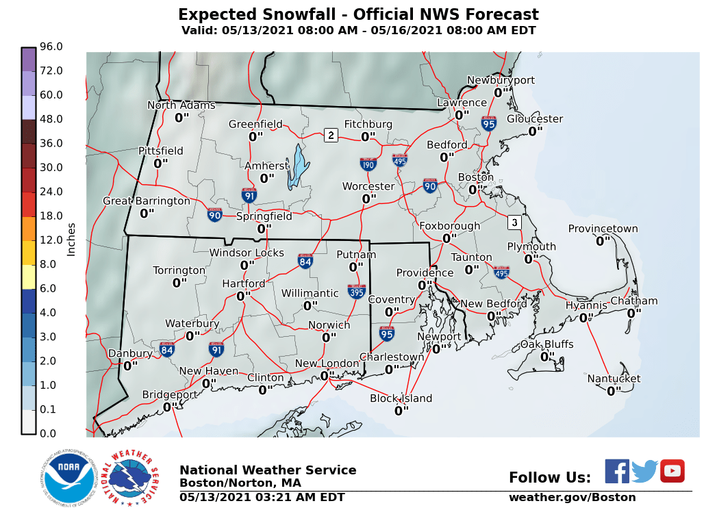
The maps below are the National Weather Service forecast snow maps with the most likely snowfall prediction.