
Snow Forecast Coating To 2 Inches Overnight 02022018
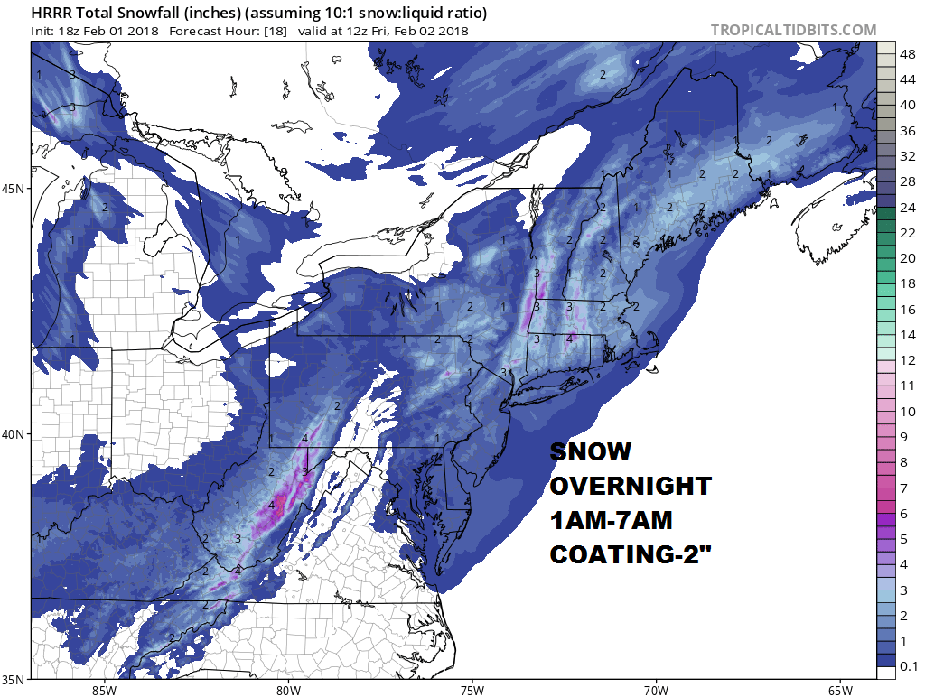
Snow Forecast Coating To 2 Inches Overnight 02022018
Judging by the satellite, radar, and weather models this afternoon a coating to 2 inches of snow is forecast for tonight. It will be rather convective in nature so some spots will see a coating while some areas that get under some heavier bursts could see an inch or two.
REGIONAL RADAR

LOCAL RADAR NEW YORK CITY

LOCAL RADAR PHILADELPHIA


The HRRR model which did better than most models on Monday lines up with this idea. Temperatures will fall rather quickly after midnight and by 7am we will be in the 20s so any moisture will freeze up. Don’t be surprised if some icy conditions develop tomorrow morning for the start of the commute. Higher amounts will occur in the Hudson Valley north of Route 84, in Northern Connecticut, and in parts of Northwest New Jersey. Again this is dependent on who gets under a bit of a convective bursts. It could snow hard for a very short period of time. This will be ending from west to east between 5am and 8am.
SATURDAY MORNING FORECAST LOW TEMPERATURES
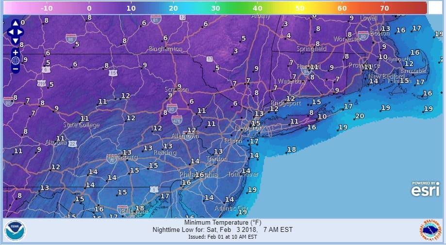
Bitter cold air follows with temperatures in the 20s all day Friday. Wind chills will make it feel like it is in the single digits. By Saturday morning lows will be in the single digits and low teens. Saturday looks nice and sunny but very cold with highs just back into the 30s.

GET JOE A CIGAR SO HE CAN RELAX!
NEW YORK CITY AND VICINITY SNOW

NEW JERSEY & PARTS OF NE PA

SOUTHERN AND SOUTHEAST NEW ENGLAND

NORTHERN NEW ENGLAND

WESTERN NEW ENGLAND

MIDDLE AND UPPER HUDSON VALLEY

CENTRAL NEW YORK & NE PA

WESTERN NEW YORK

CENTRAL & SOUTH CENTRAL PA

VIRGINIA & MARYLAND

DAILY NORTHEAST SNOWFALL

Please be advised that these are National Weather Service Forecast Maps and they auto update. Each office may update at different times and some offices are slower to update then others. Maps are usually updated before 5am and & 5pm however they may be updated at other times depending on forecast conditions. These are not my forecasts. My forecasts can be found on the JOE’S SNOWFORECAST PAGE. Individual forecasts for specific areas may also be found when conditions warrant on the my area forecasts. Those can be found on the website menu. Click on forecasts and then select your specific area.
SHOP THE JOESTRADAMUS STORE