
Snow Chances Depend On Blocking

Snow Chances Depend On Blocking
I have been repeatedly trying to emphasize the ideas on blocking can be very overstated. You can have all the blocking in the world but if the blocking is not in the right place, or if the resulting ridges and troughs are not in the right place, it won’t produce the outcome that you might expect for might like (pay attention snow lovers).
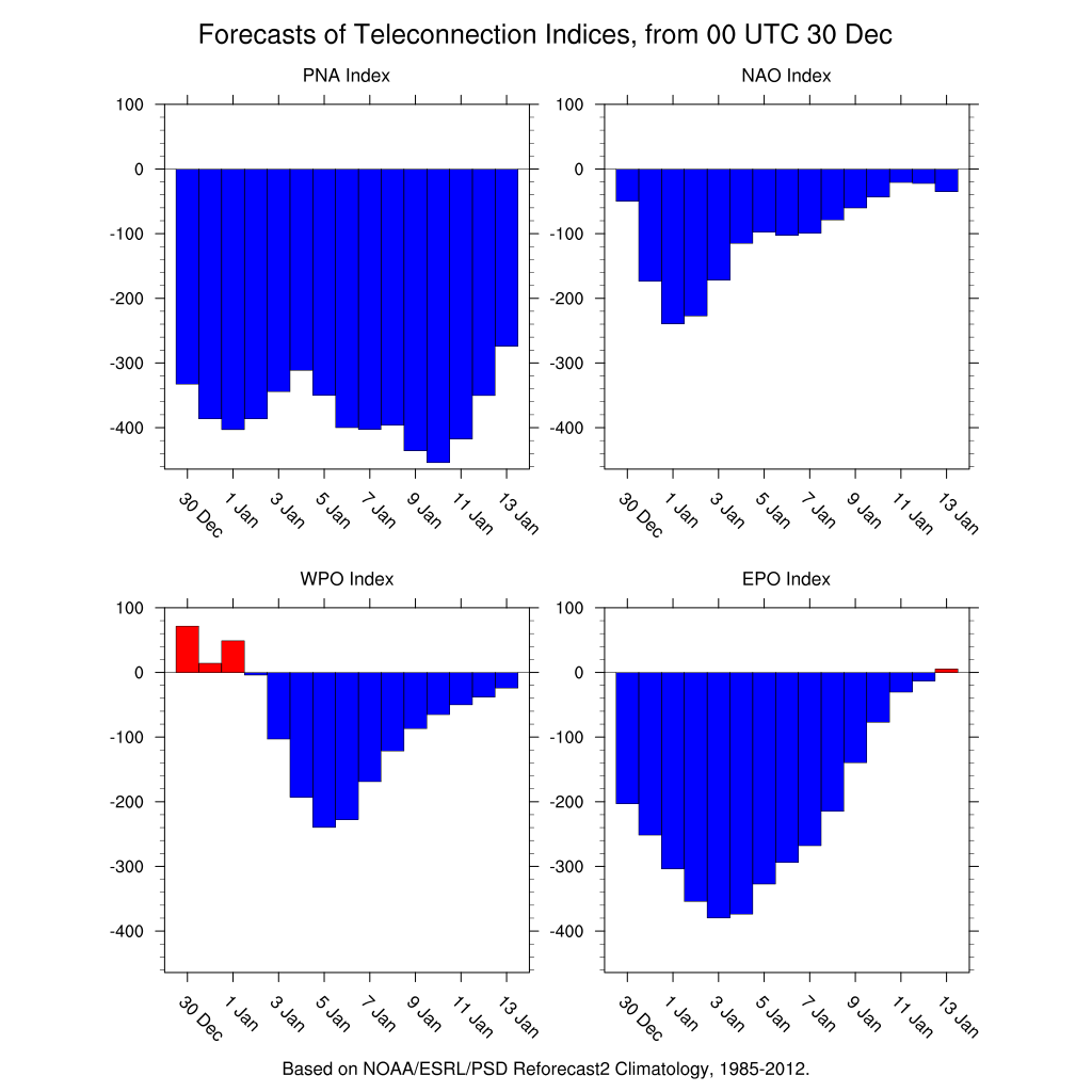
Today’s index are rather astounding considering how off the wall extreme they are forecast to reach. The East Pacific Oscillation and the North Atlantic Oscillation both reach strong levels. The EPO actually goes to an extreme negative late next week. The Pacific North America pattern index which produces a strong ridge in the west and a deep trough in the east when it is positive, is about as off the wall negative as they come. This would normally mean you can’t have a big snow storm in the east. Or can you? Big classic storms are not the only way we could see a big snowfall. The state of the indices suggests that rather than the so called classic set ups, we could see setups in a different way. The state of the indices suggests we could see overrunning events. Overrunning is warm air moving up and over cold air producing precipitation. All that is required is a stalled front to the south, cold air to the north, and a little wave to buckle the front and start the process. This could be what we will be dealing with going forward.
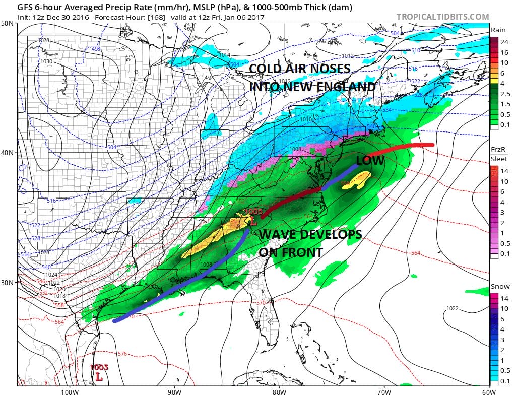
Weather models have been hinting at this idea for days and they seem to be coming into focus on this as we draw inside the day 7 time frame. There are actually 2 waves on this front that the GFS and the European both show. The difference in the two models is that the GFS makes more with the first wave and less with the second, while the European makes more with the second and less with the first. Where the difference lies is with the approaching upper trough from the west.

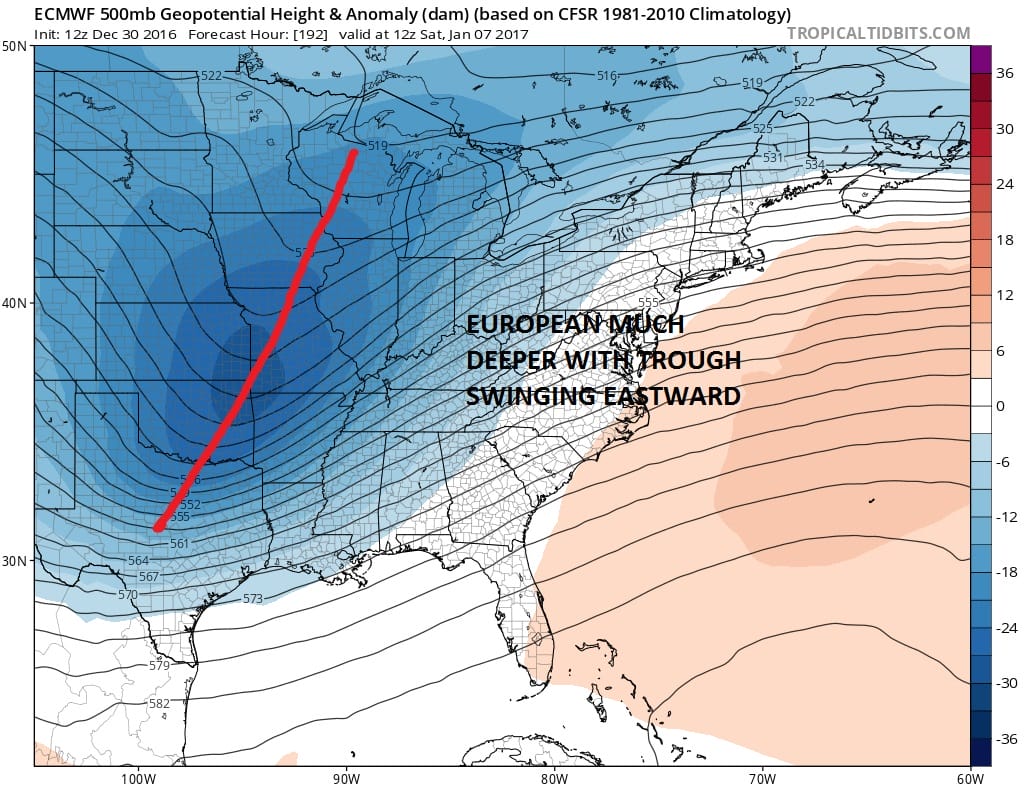
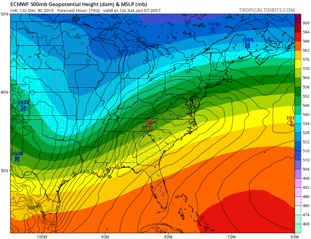
You can see the difference in how the two models handle the approaching trough with the European much deeper than the GFS. This is why the European emphasizes the second wave more than the first. This is also why the European brings big snows to the interior Mid Atlantic and all of the Northeast (including the coast). The GFS brings some precipitation with the first wave and none of consequence with the second. These are the puzzle pieces we have to deal with. Remember this is a puzzle where the pieces can change in size and scope while you are trying to piece it together.
MANY THANKS TO TROPICAL TIDBITS FOR THE WONDERFUL USE OF THE MAPS
SNOW REMOVAL COMPANIES FOR YOUR WINTER NEEDS
LONG ISLAND ROCKLAND COUNTY Connecticut

![]()

ROCKLAND COUNTY TRI STATE SNOW REMOVAL JOHNSTOWN PA


FiOS1 News Weather Forecast For Long Island
FiOS1 News Weather Forecast For New Jersey
FiOS1 News Weather Forecast For Hudson Valley
NATIONAL WEATHER SERVICE SNOW FORECASTS
LATEST JOESTRADAMUS ON THE LONG RANGE
Weather App

Don’t be without Meteorologist Joe Cioffi’s weather app. It is really a meteorologist app because you get my forecasts and my analysis and not some automated computer generated forecast based on the GFS model. This is why your app forecast changes every 6 hours. It is model driven with no human input at all. It gives you an icon, a temperature and no insight whatsoever.
It is a complete weather app to suit your forecast needs. All the weather information you need is right on your phone. Android or I-phone, use it to keep track of all the latest weather information and forecasts. This weather app is also free of advertising so you don’t have to worry about security issues with your device. An accurate forecast and no worries that your device is being compromised.
Use it in conjunction with my website and my facebook and twitter and you have complete weather coverage of all the latest weather and the long range outlook. The website has been redone and upgraded. Its easy to use and everything is archived so you can see how well Joe does or doesn’t do when it comes to forecasts and outlooks.
Just click on the google play button or the apple store button on the sidebar for my app which is on My Weather Concierge. Download the app for free. Subscribe to my forecasts on an ad free environment for just 99 cents a month.
Get my forecasts in the palm of your hand for less than the cost of a cup of Joe!
![]()
