

Smokey Haze Next Few Days Showers Thunderstorms Friday Saturday

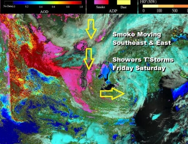
We will start the day off the with the dust satellite loop which shows Canada and much of the US north of 35 degrees north. The areas of some and dust show up in the pink/magenta areas and we see this area spreading southward from Alberta Province into the Western Great Lakes and into the Ohio Valley and the Eastern US, mostly Northern Mid Atlantic to New England. For now the smokey haze remains at low levels for much of the area from the Plains to the Eastern US with the acception of Minnesota and Wisconsin where the density of the smoke warrents Air Quality Alerts.
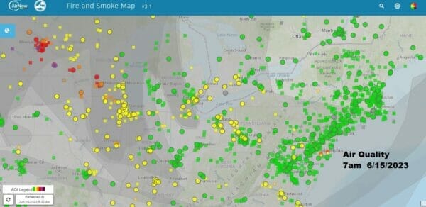
The observations for the fire and smoke courtesy of https://fire.airnow.gov/ show good air quality in the cities in green, moderate pollution levels in yellow. Orange and red areas show places where air quality is problematic or poor. The flow continues to come out of Canada around an upper low in the Northeast and a new upper low dropping southeastward from Canada into the Northeast.
These upper lows are driving the weather pattern through the weekend but at least today we catch a bit of a break as the first upper low pulls out from New England. We are expecting sunshine today through some patchy clouds. There will likely be a light smokey haze but air quality in the Northeast and Mid Atlantic is mostly fine.
SATELLITE

WEATHER RADAR

This is going to be a rain free day and the satellite and radar loops confirm this. Other than some scattered showers well to the north in Upstate NY and into Northern New England, it will be dry along the coastal plain. Most high temperatures today will be in the 70s and sea breezes will be confined mainly to the beaches.
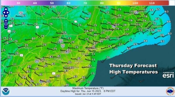
This is a busy pattern and a cool pattern that we are in and it is about to get busier as upper low after upper low drops southward from Canada and into the Northeast. The first one comes along Friday and it will be a system much like yesterday’s which will produce showers and some thunderstorms during the afternoon and evening.

The problem is that this system will not be getting out of the way but lingering along the coast. A wave develops on the front and we will have to wait for the wave to exit for any kind of general improvement. Showers and thunderstorms will probably continue on and off Friday night into at least part of Saturday until the low pulls away Saturday night. High temperatures Friday will be in the 70s an Saturday highs might have a tough time getting out of the 60s in many areas though I would think areas in South Jersey and Southern Pennsylvania along with points southward could reach into the 70s.


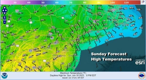
Sunday is Father’s Day and it will be the better of the two weekend days. We can’t rule out the chance for a shower or thunderstorm but any chance would be inland and for most folks, it will be no worse than a mix of sun and clouds for Sunday. High temperatures Sunday afternoon will be in the upper 70s and lower 80s.
Monday is Juneteenth which means we have a three day holiday weekend and it looks like we will have sunshine and just a few clouds for Monday with highs in the upper 70s to middle 80s from coast to inland areas. Rain chances are likely to increase as next week wears on.
BE SURE TO DOWNLOAD THE FREE METEOROLOGIST JOE CIOFFI WEATHER APP &
ANGRY BEN’S FREE WEATHER APP “THE ANGRY WEATHERMAN!
MANY THANKS TO TROPICAL TIDBITS FOR THE USE OF MAPS
Please note that with regards to any severe weather, tropical storms, or hurricanes, should a storm be threatening, please consult your local National Weather Service office or your local government officials about what action you should be taking to protect life and property.
(Amazon is an affilate of Meteorologist Joe Cioffi & earns commissions on sales.)


