Showers Tonight Warmer Tuesday Chance Thunderstorms Wednesday

Weather in 5/Joe & Joe Weather Show Latest Podcast
Showers Tonight Warmer Tuesday Chance Thunderstorms Wednesday
Clouds and the east wind kept temperatures on Long Island in check today. We have seen a few showers move through during the afternoon and there are more scattered showers on the radars to the south. A warm front will slowly edge northward tonight and it should pass though barely by Tuesday morning. Look for some showers tonight. Temperatures overnight will hold in the 50s.
SATELLITE

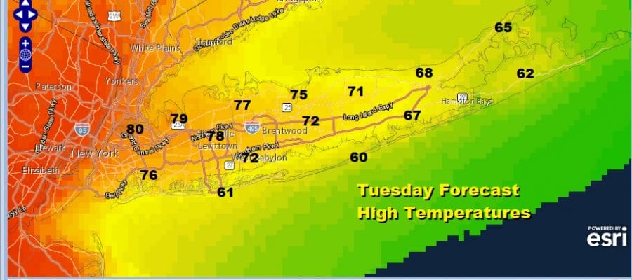
Tuesday the warm front will be just to the east and north of Long Island which makes the forecast highs rather tenuous. A little shift to the south will mean more of an ocean wind. That certainly will be the cast on the East End with highs just into the 60s but there should be enough of a push north and enough sunshine breaking through the clouds to take temperatures in the 70s inland and west away from the ocean.

Another wave moves into Upstate NY Tuesday night which will set up another buckling of the warm front. First southward and then northward look for a few showers Tuesday night as temperatures drop to the low and mid 50s. Wednesday is tricky. The warm front will be nearby and a cold front comes in from the west. Look for clouds and the chance for showers and possibly a thunderstorm. Highs Wednesday will be in the 60s. There is severe weather risk from NYC southward where the warm sector will set up. Long Island should be just out of this zone.

Thursday will be a cool day with some sunshine and clouds. Highs will be in the low to mid 60s. Then another wave develops on a stalled front to our south and intensifies offshore. All the models keep this low to the east but an upper trough will swing through across the Great Lakes putting us in clouds and some showers on Friday. Highs will be in the mid 50s to around 60.

The weekend is shaping up okay but not perfect. Saturday looks a little better than Sunday with sun and clouds for Saturday with highs in the 60s. Sunday Mother’s Day brings another warm front battle so look for increasing clouds and there is the chance for showers developing Sunday evening but the dayside should be dry. Highs will be mostly in the 60s.
BE SURE TO DOWNLOAD THE FREE METEOROLOGIST JOE CIOFFI WEATHER APP &
ANGRY BEN’S FREE WEATHER APP “THE ANGRY WEATHERMAN!

MANY THANKS TO TROPICAL TIDBITS & F5 WEATHER FOR THE USE OF MAPS
Please note that with regards to any severe weather, tropical storms, or hurricanes, should a storm be threatening, please consult your local National Weather Service office or your local government officials about what action you should be taking to protect life and property.