
Showers This Evening Moving East Sunshine Wednesday Windy Colder Thursday
Another day of gloom and a little bit of doom has come to a close. We continue to be covered by clouds from Sunday’s cold front that stalled out across the Southern Mid Atlantic states. We are seeing a little wave on that front that is being helped along by a weak low moving across the Great Lakes. Look for a few showers this evening and into the first part of tonight with leftover clouds to follow though by morning much of the cloud cover should have been pushed away to the south and east.
SATELLITE

REGIONAL RADAR

Regional and local radars are picking up on some showers moving across New Jersey to the Hudson Valley and Long Island. The showers aren’t producing much as the make their way out into the coastal waters. There isn’t much of anything going on to the west in Pennsylvania so once these showers are done we should be dry the remainder of the night.
LOCAL RADAR NEW YORK CITY

LOCAL RADAR PHILADELPHIA


Wednesday may actually turn out to be a nice day with partly to mostly sunny skies as highs reach the upper 40s and lower 50s in most places. Another low will be moving across upstate NY and Central New England Wednesday night with a trailing cold front and the chance for a scattered shower or two. Then the winds will start cranking up again on Thursday.
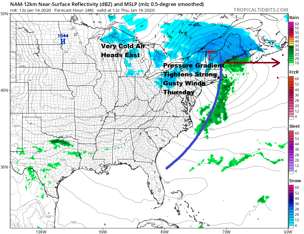
The pressure gradient tightens between the storm developing over Eastern New England and high pressure building over the Great Lakes. Northwest winds will pickup to 20 to 30 mph area wide with gusts over 40 mph possible. Also temperatures will reach their highs early in the day in the mid 40s and hold or gradually ease as the day wears on. Very cold air comes in Thursday night and by Friday morning lows will be in the 20s.
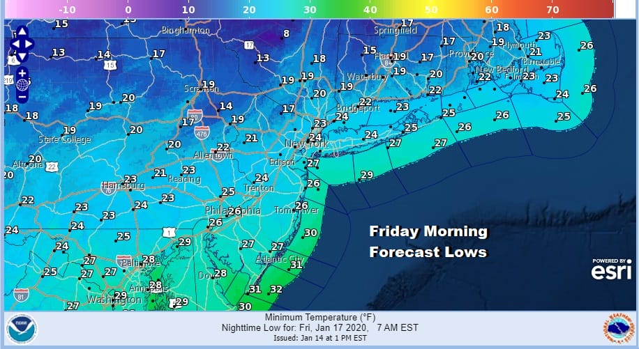
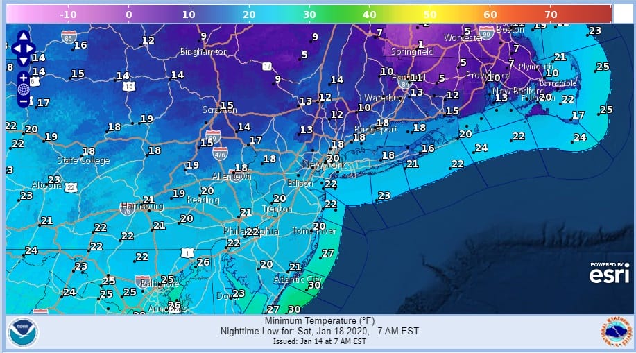
Don’t expect much of a rebound on Friday as temperatures will likely only make it back to near 30 or so in spite of a good deal of sunshine and then drop to the teens to near 20 Saturday morning; single digits inland north and west of the coast.
Saturday of course we will be dealing with low pressure that heads out of the Plains and moves across the Great Lakes as the primary low heads east. A secondary probably forms somewhere near Long Island late Saturday evening when by then much of the area will have changed over to sleet and rain. The question is arrival time and how much snow falls in about a 4 to 6 hour time frame along the coast with perhaps slightly longer snowfall inland.
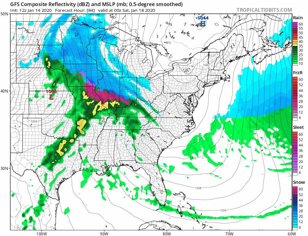
The primary low remains too strong and too far north for coastal areas. It will be a matter of how long does cold air hold on along the coast. A few hours of an east wind off 40 degree water and the low levels will be shot even with temperatures starting out the day close to 20. The high will only hold on for so long. We didn’t see much today on model runs that was a big surprise.
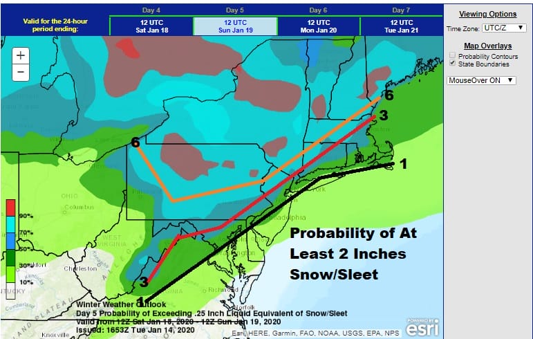
I’ve been playing around today with the Weather Prediction Center’s map showing the percentage chance of at least 2 inches (.25 liquid equivalent) and added where I think the 1, 3 and 6 inch snow lines will be. Unless cold air is more important and the primary low is a little weaker and further south so it buys a couple of extra hours, it is hard to see how this could be anything more that what I’m indicating above. However it is early in the game and models still have time to move around a bit in the next day or 2. Late tomorrow we should have a good idea on how this all plays out. Once the storm is done very cold air will start off next week.
BE SURE TO DOWNLOAD THE FREE METEOROLOGIST JOE CIOFFI WEATHER APP &
ANGRY BEN’S FREE WEATHER APP “THE ANGRY WEATHERMAN!
MANY THANKS TO TROPICAL TIDBITS FOR THE USE OF MAPS
Please note that with regards to any severe weather, tropical storms, or hurricanes, should a storm be threatening, please consult your local National Weather Service office or your local government officials about what action you should be taking to protect life and property.