Weather Changes Ahead More Cold Fronts More Cold Shots
We had some showers move through this morning as the next cold front is approaching from the Ohio Valley. This is not a big deal as far as rain is concerned. There appears to be a large enough gap in between shower bands to allow for a rain free period today. More showers are likely to develop later this afternoon and into the first part of tonight. Temperatures will be in the 60s to day. This is the first in a series of cold fronts that we will be dealing with this week. Each one has a shot of cold air behind it.
EASTERN SATELLITE

REGIONAL RADAR

Two areas of showers are showing up on the radar this morning with one that has now moved into Southern England and the second that is down in the Mid Atlantic from Northeastern Virginia to Delmarva with not much going on in between.
LOCAL RADAR NEW YORK CITY

LOCAL RADAR PHILADELPHIA


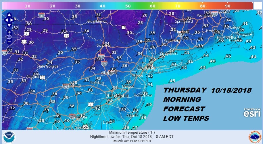
Showers will likely develop for the evening commute as the cold front passes. Then we will see drier air returning on Tuesday with clouds and some sunshine with highs in the 50s to near 60. A second front passes on Wednesday with a re-enforcing shot of cold air and that sets us up for a chilly Wednesday and Thursday with a cold Thursday morning. Highs both days will be in the 50s and low Thursday morning will be in the upper 20s to upper 30s with frosts and freezes likely.
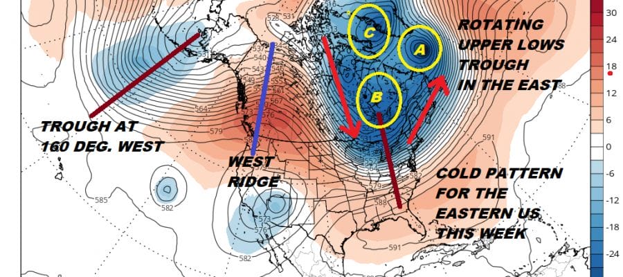
The long range pattern is solidly cold for the Eastern US with a trough in the east and a ridge in the west scenario. That will bring down shot after shot of colder air and the one that is coming over next weekend will be particularly cold with the likelihood of widespread frosts and freezes and even the first snow showers showing up in some inland and elevated areas.

Eventually a pattern like this could lead some storm issues in the long range as well and there seems to be some support for something toward months end but that remains far down the road at this stage of the game. The colder pattern does look solid however for at least the next 2 weeks and possibly longer.
AS FAR AS THE LONG RANGE GOES, WE ARE WATCHING NORTH AMERICA & SIBERIANS SNOW COVER GROWTH SO CHECK THE LATEST JOESTRADAMUS POST ON THIS.
SUBSCRIBE TO PATREON FOR A WEATHER EXPERIENCE FREE OF ADS, EXCLUSIVE VIDEOS FOR MEMBERS ONLY AND MUCH MORE…STARTS AT $2 A MONTH..MESSAGE ME AT ANY TIME

MANY THANKS TO TROPICAL TIDBITS FOR THE USE OF MAPS
Please note that with regards to any tropical storms or hurricanes, should a storm be threatening, please consult your local National Weather Service office or your local government officials about what action you should be taking to protect life and property.
LATEST JOESTRADAMUS ON THE LONG RANGE


