Showers Approaching For Tonight Into Monday
Week Ahead Not Looking Promising

Showers Approaching For Tonight Into Monday Week Ahead Not Looking Promising
Much of the area from Eastern Pennsylvania to Southern New England has managed to hang on the dry air and the sunshine that went with it. Now we see an arm of clouds to the southwest and that will gradually begin to take over as we head into this evening and tonight. This extends back to a storm in the Western Great Lakes. There isn’t much energy left with this system so it will be a matter of how the showers hold on as we go through this evening and tonight. They are likely to weaken once the daytime heating of the day shuts off.
SATELLITE

WEATHER RADAR

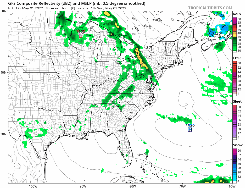
Regional radar is showing showers across much of Pennsylvania west of I-81 at 3pm eastern time. There are some heavier downpours in the mix and even a rumble or two of thunder. This will come overhead tonight and they should slowly weaken. Most temperatures are topping in the 60s to near 70 this afternoon with the exception of Southern Connecticut to Long Island where it is in the 50s to near 60.
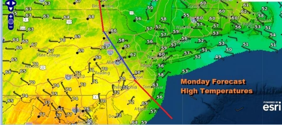
The latest GFS run takes us from this evening through Thursday morning. Two weather systems are in play in this time frame. We have tonight and Monday and a frontal boundary stalls on a diagonal Monday. As the high temperature forecast map shows, if you are north and east of the boundary temperatures will not get out of the 50s. If you are south and west of the boundary you will get into the 70s.
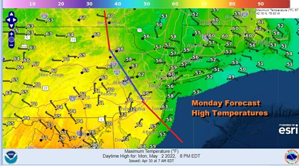
As far as conditions are concerned, we will see clouds fog showers and drizzle to the northeast of the boundary (Central New Jersey north to the Hudson Valley and east into New England). Everyone else see changeable skies with some sun and scattered showers or a thunderstorm. This pulls out Monday night and then we head to Tuesday.
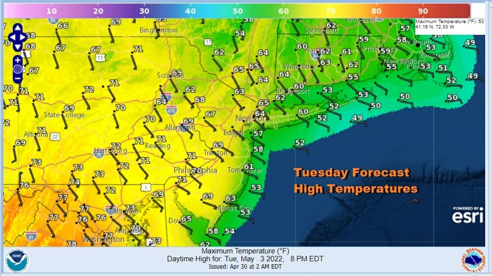
Tuesday will be a day of changeable sky conditions but to the east in Southern New England to New Jersey clouds will be dominant while inland there could be more sun so once again there will be a wide range in temperatures from east to west. Showers will arrive Tuesday night and continue on and off Wednesday. Highs will be in the 60s except for Southern New England and Eastern Long Island where it will be in the 50s. Once this system passes we get a short break Wednesday night into Thursday.

Things become a little murkier when it comes to the end of the week and into next weekend. Weather models differ on how they handle the block. The GFS allows the next system to arrive bringing rain Thursday night and continuing on and off into Saturday before weather conditions improve. The European slows the next system down keeping Thursday and Friday mainly dry and then washes out Friday night through Sunday. For now we will lean toward the GFS idea on the timing though frankly confidence is not high. Thursday will be a day of maybe suns but clouds taking over and rain comes in Thursday night. A northeast wind will develop late in the day but we should see highs in the 60s. Friday and Saturday would feature an ocean wind and raw conditions with rain and highs in the 50s. Then we should dry out for Mother’s day. That is the plan at the moment until we can resolve the timing issues of both models.
BE SURE TO DOWNLOAD THE FREE METEOROLOGIST JOE CIOFFI WEATHER APP &
ANGRY BEN’S FREE WEATHER APP “THE ANGRY WEATHERMAN!
MANY THANKS TO TROPICAL TIDBITS & F5 WEATHER FOR THE USE OF MAPS
Please note that with regards to any severe weather, tropical storms, or hurricanes, should a storm be threatening, please consult your local National Weather Service office or your local government officials about what action you should be taking to protect life and property.