Showers Ahead of a Cold Front Ahead Of Another Cold Air Mass
Cold air is pulling out today as we hit bottom in the 20s to around 30 degrees this morning. Arriving clouds are ahead of a cold front and south to southwest winds will allow for temperatures to warm up today reaching highs in the mid to upper 40s. Low pressure over the Great Lakes moves into Upstate New York and New England where we will see some snow there. Winter Weather Advisories and some Winter Storm Warnings are up from Northern Pennsylvania to Northeast New York, but again no issues along the coastal plain of Eastern Pennsylvania to Southern New England other than some nuisance rain showers this afternoon and evening.
SATELLITE WITH LIGHTNING STRIKES
WEATHER RADAR
We do not expect to see much in the way of rain from this cold front. We are talking a quarter of an inch or less everywhere and, in some places, a tenth of an inch or less. Once the front passes skies will clear and gusty northwest wnds will develop. Thursday morning lows will bottom in the 20s to around 30 degrees.
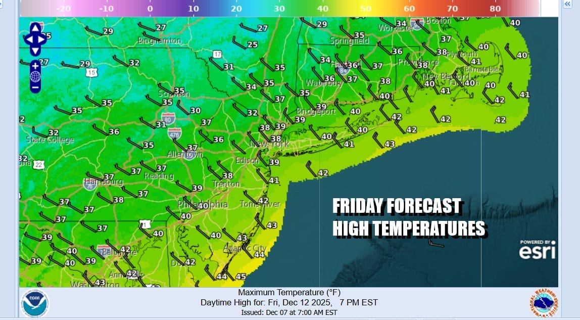
Thursday is going to be a windy and cold day with gusty northwest winds of 20 to occasionally 30 mph. We will have no worse than partly sunny skies and high temperatures will reach the upper 30s and lower 40s. Then we head down into the 20s for Friday morning as skies stay clear. Friday will be a sunny but cold day with high temperatures mostly in the 30s.
On to the weekend where we have yet another arctic boundary that will be headed our way Saturday. This will probably produce some clouds and there might even be some scattered snow showers well inland. This arctic boundary is ahead of another shot of very cold air that will come in during Sunday and then hang around into the first part of next week. The question is whether a wave develops on that boundary and brings some snow before the bulk of the cold air arrives.
Latest model runs suggest that the cold dry air and the upper jet stream that goes along with it, crushes any wave development to the south keeping any snow to a minimum and mainly over Southern New Jersey, Southeast Pennsylvania into Maryland for a very short period of time. We are going to give models time to settle this out today and Thursday before we come to a final verdict. We mentioned a few days ago that this was a possibility that the north would overwhelm the south and it seems that is direction we are going. Either way very cold air comes in Sunday through Tuesday of next week before temperatures begin to moderate later next week.
BE SURE TO DOWNLOAD THE FREE METEOROLOGIST JOE CIOFFI WEATHER APP \&
ANGRY BEN’S FREE WEATHER APP “THE ANGRY WEATHERMAN!
MANY THANKS TO TROPICAL TIDBITS FOR THE USE OF MAPS
Please note that with regards to any severe weather, tropical storms, or hurricanes, should a storm be threatening, please consult your local National Weather Service office or your local government officials about what action you should be taking to protect life and property.