Shower Thunderstorm Risk Next 2 Days Weather Improves Mid to Lake Week,
No Issues from Franklin or Idalia Other Than Rough Surf

Shower Thunderstorm Risk Next 2 Days Weather Improves Mid to Lake Week,
No Issues from Franklin or Idalia
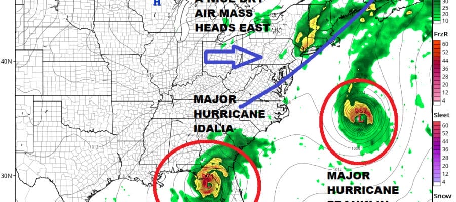
The new week begins with one major hurricane, Franklin, which is well off the Southeast US coast. Satellite loops and air force recon show that Franklin became the first major hurricane of the season overnight with winds now at 115 mph. It is moving northwestward and is forecast to turn north and than northeast tomorrow and Wednesday so it will first pass west of Bermuda and then pass to the north of the island as it heads out to sea. The only risks here will be the roughing up of the ocean as the week wears on bringing rip currents and possibly some beach erosion in some areas.

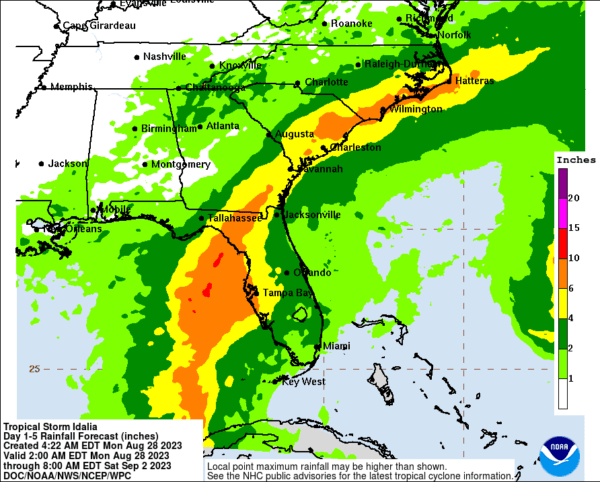
Idalia meanwhile is forecast to become a major hurricane as well as it moves northward out of the Northwest Caribbean and then into the Eastern Gulf of Mexico. It will turn northeast making a landfall along the coast of the Florida Big Bend probably Wednesday morning. Conditions have become favorable for rapid strengthening of Idalia over the next 48 hours and it is forecast to reach at least category 3 status before landfall. There is a chance it could even reach category 4 as it nears the Florida coast. Then Idalia is forecast to move northeast and straddle the Georgia, South Carolina and North Carolina coastline before turning to the east. Right now we do not expect Idalia to head north up the Middle Atlantic coast and into New England as high pressure should be enough to suppress the track to the south and east.
SATELLITE WITH LIGHTNING STRIKES

WEATHER RADAR

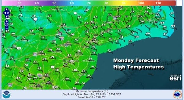
Meanwhile today we are seeing an increase in both humidity and an onshore flow with an east wind. This will likely keep much of the region in Eastern Pennsylvania to Southern New England in clouds so look for changeable sky conditions and there is the chance for a scattered shower or thunderstorm inland. most highs will be in the 70s except near 80 in South Jersey and points southward.
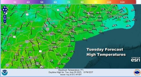
Overnight we will likely see clouds and the chance for a passing shower or thunderstorm with lows in the 60s to near 70. Tuesday will be a humid day with changeable sky conditions ranging from cloudy to some areas going briefly partly sunny and againt there is the chance for a shower or thunderstorm. Highs will be in the 70s to some warm spots near 80. A cold front Tuesday night will likely bring an area of more numerous showers and thunderstorms that should exit Wednesday morning.

After Wednesday, weather conditions improve with clouds giving way to sunshine with highs in the 70s. Humidity levels will drop leaving us with some nice weather Thursday into Friday. The one issue for Thursday is that Hurricane Idalia or at that point Tropical Storm Idalia will be straddling the Carolina coastline and heavy rains will be occuring inland in the Carolinas and that rain might reach as far north as Southeast Virginia and perhaps the southern part of the Delmarva Peninsula.
HIgh clouds might make it as far north as the Hudson Valley and Southern New England masking some of the sunshine Thursday. Temperatures will likely top out in the 70s. However as stated earlier we think any rain stays well southeast as Idalia turns eastward. Friday looks like a nice sunny day with highs in the 70s to near 80. The Labor Day holiday weekend is shaping up to be warm but dry with sunshine all three days, Saturday through Monday with highs getting back into the 80s each day.
BE SURE TO DOWNLOAD THE FREE METEOROLOGIST JOE CIOFFI WEATHER APP &
ANGRY BEN’S FREE WEATHER APP “THE ANGRY WEATHERMAN!
MANY THANKS TO TROPICAL TIDBITS FOR THE USE OF MAPS
Please note that with regards to any severe weather, tropical storms, or hurricanes, should a storm be threatening, please consult your local National Weather Service office or your local government officials about what action you should be taking to protect life and property.
(Amazon is an affilate of Meteorologist Joe Cioffi & earns commissions on sales.)


