Short But Brutal Heat Humidity Friday Into Monday
As far as heatwaves go, 3 days of 90 plus is nothing all that unusual. 2 of those 3 days will be brutally hot and humid and that would be Saturday and Sunday with highs reaching 100 degrees in many locations. Heat indices will reach 110 or higher on both days and other than an isolated pop up thunderstorm, the 3 day stretch of Friday through Sunday will be mostly rain free. Today we are catching a bit of a break thanks to all the thunderstorms from last night and lots of clouds that are around today. Another upper trough will be moving east and sweeping these clouds out later tonight. There could be some downpours or a thunderstorms scattered around for the rest of today into this evening but I don’t expect to see widespread severe weather. The lack of daytime heating will cut back on thunderstorm development. Highs will be in the 80s and some areas north and west of NYC will probably stay in the reasonable 70s today.
SATELLITE

REGIONAL RADAR

Looking at the regional and local radars, clearly the thunderstorm activity is much less than yesterday. We are seeing some downpours on the local radars moving from west to east. Nothing severe is showing up but there could be some heavier downpours in some of these cells later today into this evening. Not everyone will see downpours today.
LOCAL RADAR NEW YORK CITY

LOCAL RADAR PHILADELPHIA


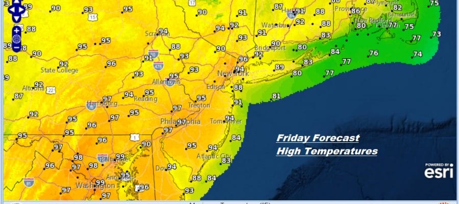
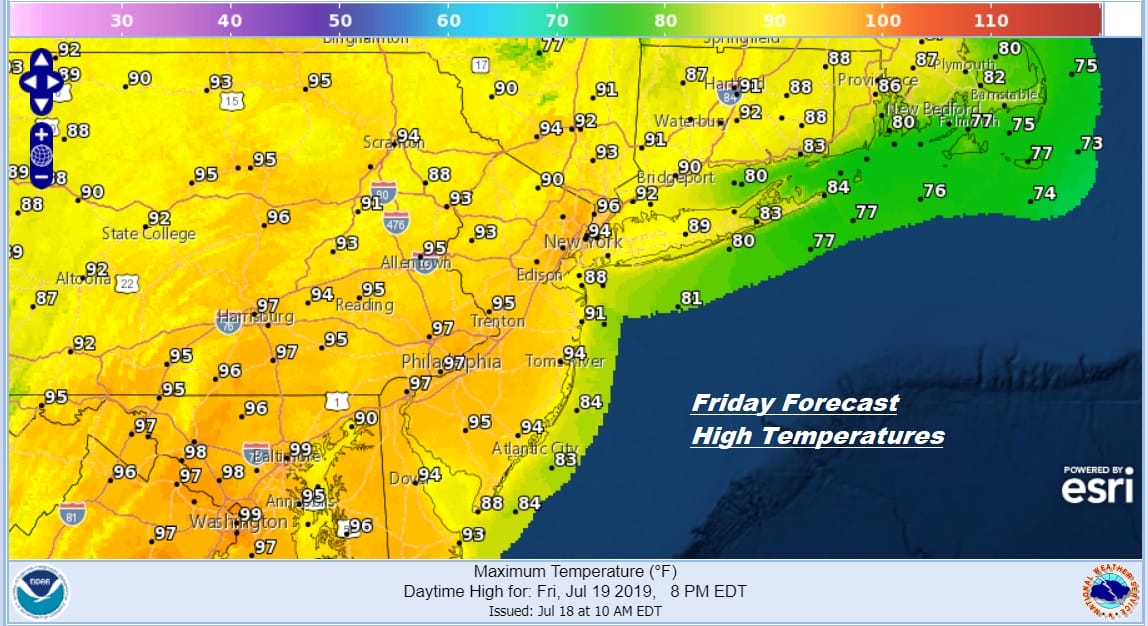
Sunshine returns Friday and temperatures will be headed back to steamy levels. Highs will reach the low to mid 90s everywhere. Humidity levels will be very high. However there are no mechanisms in the atmosphere to trigger anything more than an pop up scattered thunderstorm. Heat indices Friday will reach 105-110 in many areas.
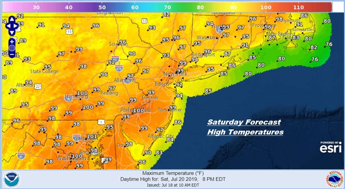
On to Saturday which is going to be just brutal with blazing sunshine and highs reaching the upper 90s to near 100 degrees in many locations. Heat indices will reach 110 to 115 in some places. All this heating could trigger off a pop up thunderstorm in one or two spots but no widespread activity is forecast.
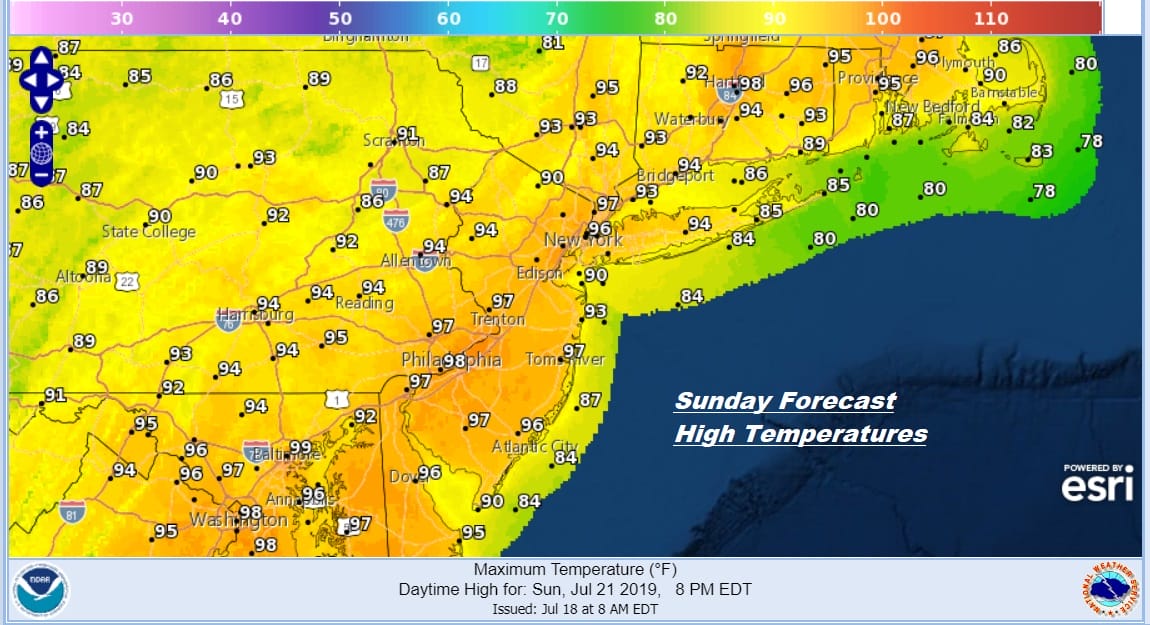
Sunday will be a repeat performance of Saturday with highs again in the upper 90s to near 100 degrees over a large geographic area from Virginia to New England. Minimal thunderstorm activity is forecast for much of the day however the next cold front will be approaching and it seems like it will get here a bit faster than what we saw earlier this week.
The front could trigger some showers and thunderstorms Sunday night. The front is going to take its time moving completely through here on Monday so it brings the chance for some thunderstorms with greater chances south of NYC and PHL. Behind the front is nice dry air and as long as the front keeps moving along, we should see lower temperatures and improving weather conditions for Tuesday through Thursday of next week.
MANY THANKS TO TROPICAL TIDBITS FOR THE USE OF MAPS
Please note that with regards to any tropical storms or hurricanes, should a storm be threatening, please consult your local National Weather Service office or your local government officials about what action you should be taking to protect life and property.


