Severe Weather Risk Today Higher Risk South Labor Day Weekend Looking Good
We have a very warm and humid day set for today and a combination of factors that could lead to severe weather late this afternoon and this evening. A cold front will be approaching. We have solid daytime heating that will send temperatures to the mid to upper 80s for highs.

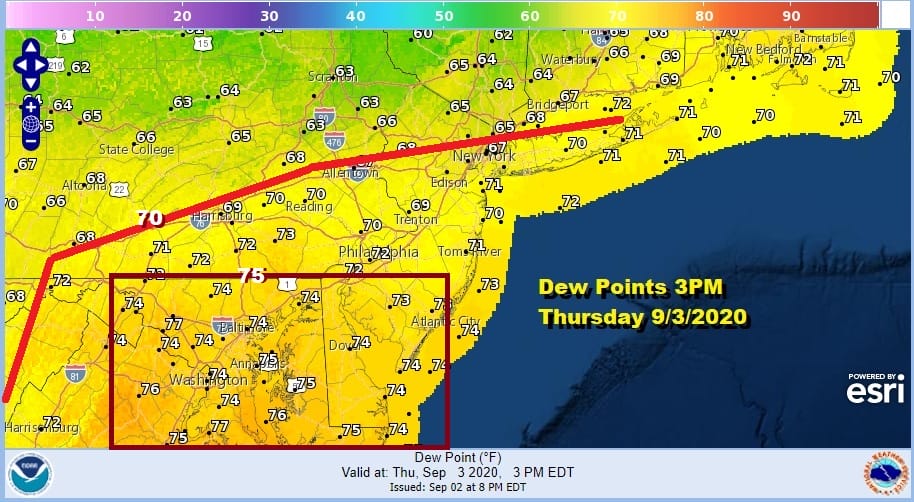
Humidity levels will be running very high today with tropical air along the East Coast. This is particularly true in areas as you head south across Maryland Delaware and Virginia where dew points will be up in the middle 70s.
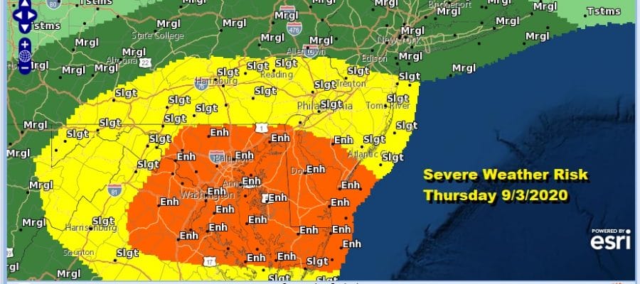
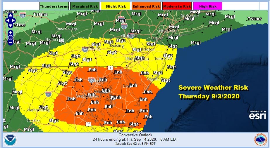
Add to that a strong short wave trough that is going to be headed through the area this evening and you have the ingredients for a severe weather outbreak. The Storm Predicition Center has areas in South Jersey southward into Delaware Maryland and Virginia in an enhanced risk for severe weather. The tornado risk i in the enhanced zone is a 10 percent chance within a 25 mile radius of any point inside the enhanced area.
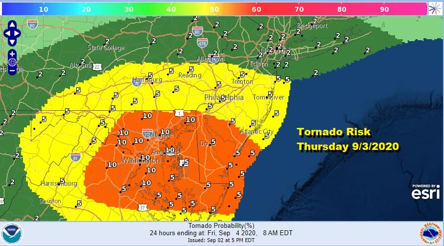
Lower risk exists further north but there is risk here with 5% reaching up to just south of NYC westward into Central New Jersy and back into Southeastern Pennsylvania. A 2% tornado risk and a marginal risk for severe thunderstorms covers the rest of Northeastern Pennsylvania, the Catskills, the Hudson Valley, Southern New England and Long Island.
SATELLITE

REGIONAL RADAR

Not much is happening on the radars this morning but activity will pick up late this afternoon into tonight. Along coastal areas we have a bit of a marine layer to start the day with low clouds but sunshine should cut through later on setting the table for thunderstorms this evening.
LOCAL RADAR NEW YORK CITY

LOCAL RADAR PHILADELPHIA


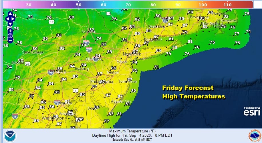
Once the cold front passes offshore late tonight and early Friday weather conditions will improve. We will start Friday with leftover clouds but that should quickly lead to sunshine and a lowering of humidity. Highs Friday will be in the low to mid 80s.
It is on to the weekend which looks very good for all three weekend days. The theme for Saturday, Sunday and for most of Monday will be sunshine and low humidity. High pressure will be building across the Ohio Valley, Middle Atlantic states and the Northeast. That means for nice days and comfortable nights. Saturday and Sunday highs will be in the mid 70s to near 80. Nighttime lows will be in the mid 50s to lower 60s in most places.
Monday Labor Day looks very good as well. Dry air will be hanging on so the humidity will remain low. The cold front approaching for Monday night is weak and will fall apart before it gets here. Sunny skies are forecast for most if not all of Monday with highs reaching the upper 70s to lower 80s. Warmer and more humid conditions will develop Tuesday into Thursday and the next cold front with a chance for showers or thunderstorms won’t get here until late Thursday. It appears that starting Friday we will see no rain for 6 days!
BE SURE TO DOWNLOAD THE FREE METEOROLOGIST JOE CIOFFI WEATHER APP &
ANGRY BEN’S FREE WEATHER APP “THE ANGRY WEATHERMAN!
MANY THANKS TO TROPICAL TIDBITS FOR THE USE OF MAPS
Please note that with regards to any severe weather, tropical storms, or hurricanes, should a storm be threatening, please consult your local National Weather Service office or your local government officials about what action you should be taking to protect life and property.


