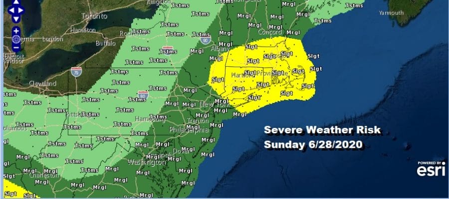
Severe Weather Risk NYC TO Boston Includes Long Island Southern Southeastern New England
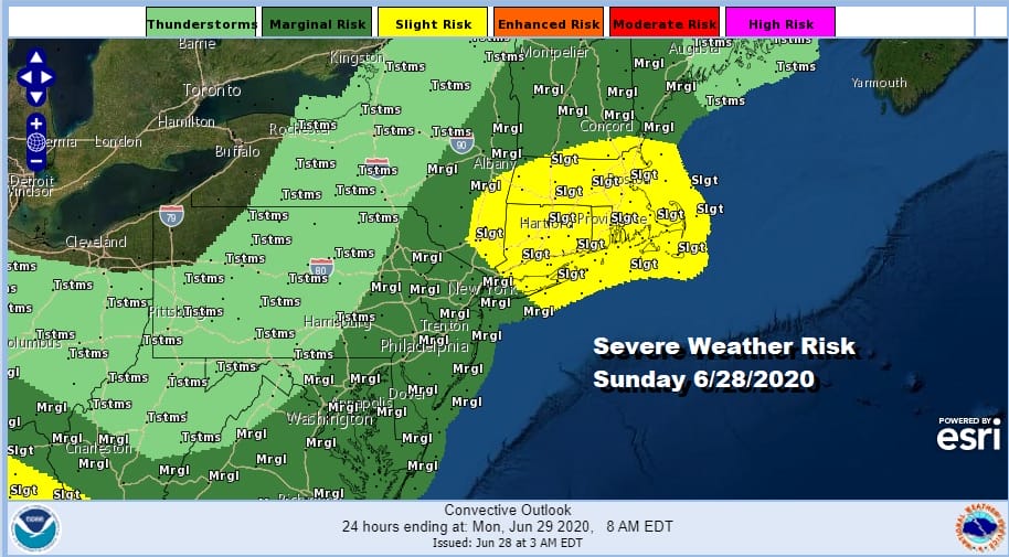
Today, Sunday, will be a very warm to hot humid day across much of the Northeast especially the coastal northeast. We have a weak frontal boundary virtually overhead and an upper low developing over Northern New England that will be impacting our weather for much of this week. An uppoer air disturbance will be swinging south today and interacting with this weak boundary. Low pressure will form over us today and this triggers off scattered thunderstorms late morning inland and then this afternoon and evening along the coast. The Storm Prediction Center has gone bullish on severe weather creating a slight risk zone from NYC east to Boston with marginal risk from Southwest Maine to the Middle Atlantic states. It will be an eye to the sky kind of day.
SATELLITE

REGIONAL RADAR

The day begins fine as evident on the satellite picture this morning however looking at the regional and local radars we are already seeing a few scattered showers and thunderstorms popping up. Expect the coverage to increase as the day wears on.
LOCAL RADAR NEW YORK CITY

LOCAL RADAR PHILADELPHIA


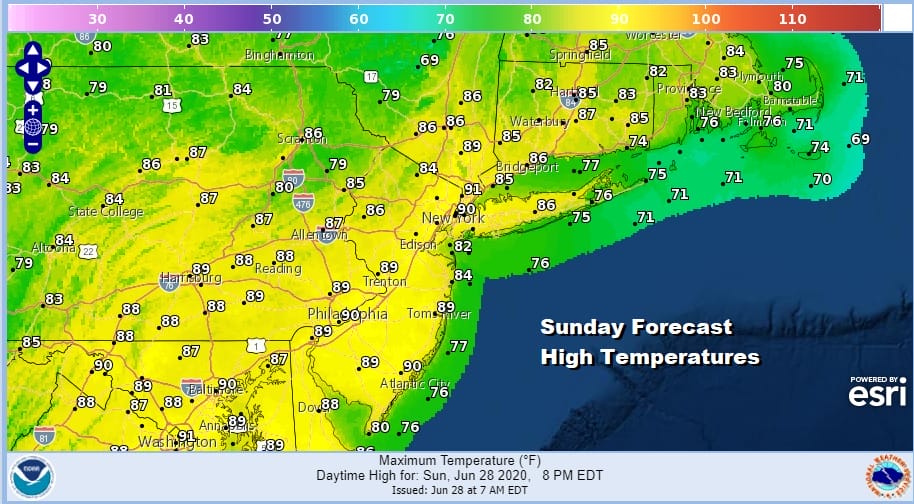
No doubt that the lower atmosphere is juicy enough for thunderstorm development as it will be a very warm to borderline hot and humid day as highs reach the upper 80s to near or just over 90 in some places depending on how much sun we get into early afternoon.
Using short term models in thunderstorm situations is always tricky and what I do is after looking at them I try and pick the one that matches what is going on in the upper air and today I settled on the NAM model which I think gives the best idea of how the sequence of events plays out this afternoon.
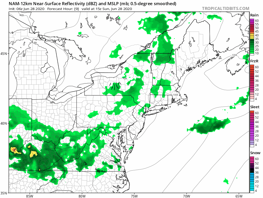
Main threat time will be anytime this afternoon between 1pm and into this evening around 7 or 8pm before it all winds down. Clouds will clear out tonight with lows in the mid 60s to lower 70s.

The week ahead is going to be all about the upper low that is sitting over New England and it doesn’t move much until late in the week. This puts us in a rather unstable atmosphere over the next few days. Mornings will start out sunny before instability takes hold and that allows for scattered showers and thunderstorms to develop. I have them in the forecast for Monday through at least Wednesday. Temperatures Monday will be in a range of between 85 and 90 degrees. Dew points will be ever so slightly lower Monday and Tuesday but it will still be on the humid side. I would suspect that we could see isolated severe thunderstorms each afternoon so each day this week will be an eye to the sky kind of day. Not everyone will see storms so it is effectively a dice roll.

Thursday we will begin to see the upper low pull out and a cold front dropping southward from Eastern Canada or as we call them back door fronts. Thursday will be very warm to hot and humid ahead of it with highs in the mid 80s to near 90. We will watch for a shower or thunderstorm Thursday night. Then it turns a bit less humid as high pressure builds southward from Eastern Canada. There should be some sunshine Friday with highs mostly in the 80s. The weekend calls for some sunshine on Saturday the 4th of July with highs in the low to mid 80s and perhaps a pop up shower or thunderstorm inland. We will hold the same idea for Sunday though the GFS model above is a little more pessimistic for Sunday. Given the volatility of the model runs lately we will remain optimistic for all three days of the holiday weekend.
BE SURE TO DOWNLOAD THE FREE METEOROLOGIST JOE CIOFFI WEATHER APP &
ANGRY BEN’S FREE WEATHER APP “THE ANGRY WEATHERMAN!
MANY THANKS TO TROPICAL TIDBITS FOR THE USE OF MAPS
Please note that with regards to any severe weather, tropical storms, or hurricanes, should a storm be threatening, please consult your local National Weather Service office or your local government officials about what action you should be taking to protect life and property.


