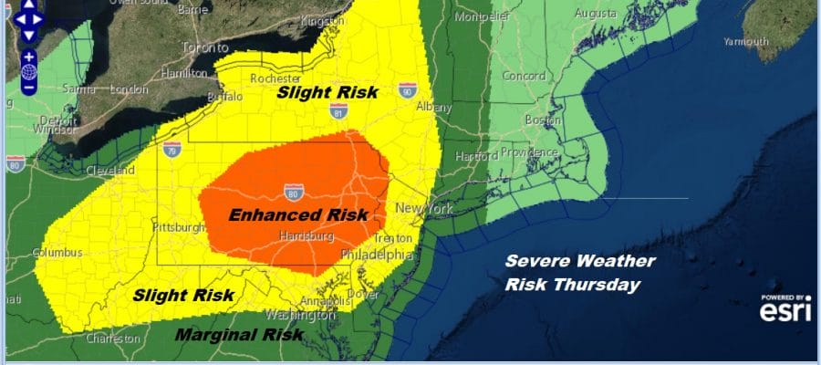
Severe Weather Risk Grows Somewhat Thursday Holiday Weekend On Course

The Storm Prediction Center has increased its severe weather risk area for Thursday adding an area of enhanced risk across much of the state of Pennsylvania and touching some of the counties in Northwest New Jersey. Slight risk extends east across New Jersey to the Hudson Valley & New York City. This is thanks to an approaching cold front that will be moving through Thursday night. Before that we have another good looking day here with lots of sunshine to start things off on this Wednesday. There is still a bit of a breeze this morning from the northwest but the wind should settle down some later today. Some high clouds could come into the mix later on. We can see that on the satellite picture this morning. There is enough dry air to keep things nice. Highs will reach into the low and middle 70s today. If winds drop off late this afternoon we could see local sea breezes develop along the immediate coast. Radars are free and clear for today.
SATELLITE

REGIONAL RADAR

Tonight more clouds will be moving in as more humid air comes in from the west. However the dry air will hang on rather strongly into Thursday morning. This creates a situation where humidity levels rise rather rapidly during the day tomorrow as a warm front goes by and a cold front approaches. If you follow the loop of the dew point map. The dew point temperature is the temperature you would have to cool the atmosphere to achieve 100% relative humidity. That happens when the temperature and the dew point are the same.

The green colors to the northwest represent the dry air behind the next cold front. That dry air arrives Friday morning. The atmosphere is going to be very unstable. The question of timing comes into play and it seems that Pennsylvania into the New Jersey Western Counties probably tap the maximum daytime heating. SPC mentions the possibility of some supercells developing out of this. This is how they access the risk.
Current indications are that storms will most likely develop along and ahead of southeast-advancing cold front spread southeast through the OH Valley and Northeast States during the afternoon and evening. Winds will strengthen as the mid-level speed max attending the shortwave trough approaches the region with effective shear supporting supercells. These storms may produce large hail, damaging wind and a couple of tornadoes as they move southeast through the region later Thursday afternoon into the evening.
…MAXIMUM RISK BY HAZARD…
Tornado: 10% SIG – Enhanced
Wind: 15% SIG – Slight
Hail: 30% SIG – Enhanced
Clouds Thursday will give way to some breaks of sun. Look for showers and thunderstorms to develop mid to late afternoon and pass through. Highs Thursday will be in the 70s. Along the immediate coast the wind direction is going to be key to whether storms hold up or if a marine layer and a south wind get involved. We will be able to access this risk better on Thursday.

Friday could be a repeat performance of yesterday where we have lots of sunshine, a gusty wind and temperatures into the 70s. This should be a good getaway day as we head into the holiday weekend. Our original idea for the weekend was that the weather for much of the time would be dry. We have two cold fronts to deal with. One arrives Saturday night with the chance for showers or a thunderstorms but the day Saturday should be fine with a mix of sun and clouds with highs in the mid 70s to lower 80s. Sunday the front hangs around to the south which may mean some clouds issues but i think there is room for some breaks of sun. Highs will be in the 80s.
Models are speeding up a front coming down from the northwest which would mean a chance for showers and thunderstorms Sunday night. This sets us up for a decent Monday with some sunshine and highs in the mid 70s to lower 80s. At least the much of the time during the day conditions will be dry. We will just have to be dodging the chance for showers at night. This is not a bad compromise.
MANY THANKS TO TROPICAL TIDBITS FOR THE USE OF MAPS
Please note that with regards to any tropical storms or hurricanes, should a storm be threatening, please consult your local National Weather Service office or your local government officials about what action you should be taking to protect life and property.


