
Severe Weather Risk Flash Flood Risks Late Today Into Tuesday
Flash Flood Watch Today Into Tonight
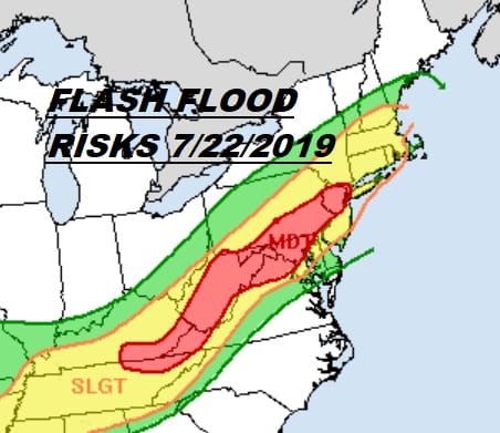
After two days of near 100 degree high temperatures and high humidity we are about to embark on a change in the short range which will be triggered by a slow moving cold front and two waves of low pressure that will be moving along on that frontal boundary. The Weather Prediction Center has a moderate risk for flash flooding from West Virginia northeastward into Pennsylvania, Northern New Jersey to NYC, Western Long Island and Southern Hudson Valley. Slight risk covers a large geographic locations in the Northeast and Middle Atlantic states. Also we have an increased severe weather risk with the Storm Prediction Center showing now a slight risk of severe weather

Not much is happening this morning on the satellite and regional radar but you can expect clouds to increase later today and radar activity to get busy this afternoon with showers and thunderstorms developing. Temperatures today will be mostly in the 80s as a cold front will be on top of us which will limit the daytime heating.
SATELLITE

REGIONAL RADAR

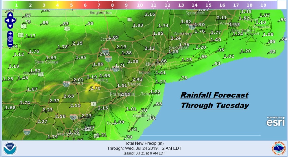
A Flash Flood Watch is in effect for today and tonight due to the excessive flash flood risk and a forecast for two or more inches of rain for the area. Thunderstorms always add an air of variability to rainfall amounts and some 3 inches plus areas are possible depending on the track of thunderstorms. Showers and thunderstorms will continue on and off this evening and overnight.
All of this should come to an end later in the day on Tuesday as the second wave of low pressure moves offshore and weather conditions improve later in the afternoon and evening. Highs will be mostly in the 70s to near 80. We will be back to sunshine for Wednesday through Friday with low humidity and highs mostly in the low to mid 80s as we take a break from the serious heat and humidity of the last few days.
MANY THANKS TO TROPICAL TIDBITS FOR THE USE OF MAPS
Please note that with regards to any tropical storms or hurricanes, should a storm be threatening, please consult your local National Weather Service office or your local government officials about what action you should be taking to protect life and property.


