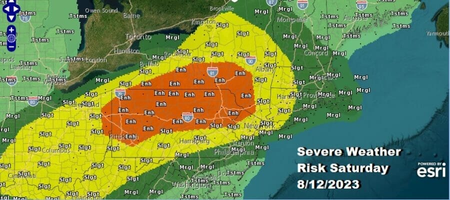
Severe Weather Risk & Elevated Tornado Risk
Pennsylvania to Western New England

Severe Weather Risk & Elevated Tornado Risk
Pennsylvania to Western New England

Today we transition over to a very warm and humid air mass as a warm front goes by to the north. Daytime heating gets underway taking high lto the mid 80s to near 90 degrees in many areas and that sets the table for severe weather risk late today and tonight. The Storm Prediction Center has expanded its area of risk to “enhanced” which extends from Eastern Ohio to Northwest New Jersey northward to the Catskills and west across much of Southern New York. Slight risk extends east and south into Western New England to more of Northern New Jersey and the rest of Pennsylvania into West Virginia.

As always with these situations, not everyone will see thunderstorms today and that usually is the case in situations like this Most of the time there are gaps where someone is getting hammered and others not so much or if at all. Today’s short range gfs FV3 model i think handles this best with warm frontal thunderstorms into the afternoon going through Upstate NY and into New England and then we see storms developing across Northern Pennsylvania during the afternoon and then they make their way east so eyes will be sharply focused on the radars today.
SATELLITE WITH LIGHTNING STRIKES

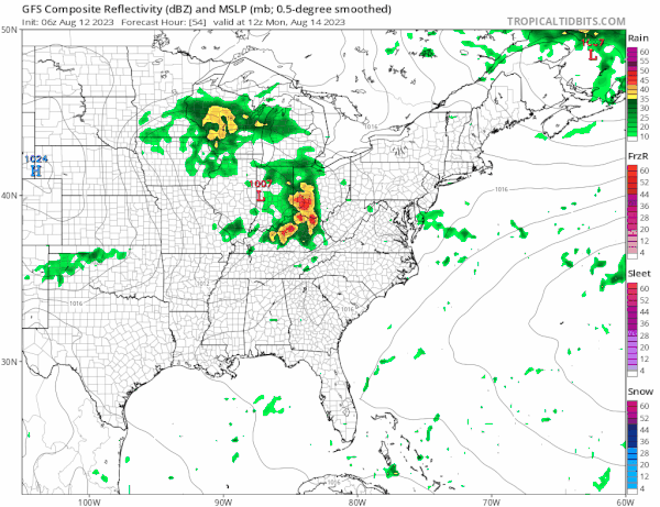
WEATHER RADAR

For the coast any thunderstorms should reach the coast later this evening unless some renegade cell develops earlier which is always possible. There might even be a shower or thunderstorm overnight in some places. Lows will be in the mid 60s to lower 70s. Sunday will be a partly sunny day and a little less humid though very warm with highs in the mid 80s to around 90 degrees. There is a chance for a scattered thunderstorm or two with the highest chances for thunderstorms in Eastern New England. There is a marginal risk for severe indicated there.

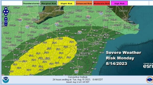
Monday sees next weather system moving across the Great Lakes with a trailing cold front. This system is coming in slower than advertised the last couple of days and it will be another one of these warm front cold front combinations. Showers and perhaps a thunderstorm will come through Monday afternoon and then we wait for the cold front that could produce showers and thunderstorms Monday night.
This opens up the possibility of severe weather risk late Monday and Monday night in much the same way we see severe weather risks for Saturday except that for now the levels are not that high. We have a marginal to slight risk indicated from the Ohio Valley to New England.
The slower system means that Monday will get more sunshine early on before the warm front approaches with showers and thunderstorms in the afternoon so high temperatures will reach into the 80s just about everywhere. Humidity levels will go up in a hurry during the day with dew points reaching the upper 60s aot near 70 in some areas so Monday will be more uncomfortable.

The cold front will pass through during Tuesday and there could be another shower or thunderstorm as it goes by but a nice dry air mass will spread into the East and South with dropping dew points and seasonal temperatures for Wednesday and Thursday. Look for sunshine both days with highs in the 80s. Late next week and into next weekend we could get into some heat and humidity as high pressure offshore builds, a west wind, and no new cold fronts will allow temperatures to warm and humidity to rise for at least a few days.
BE SURE TO DOWNLOAD THE FREE METEOROLOGIST JOE CIOFFI WEATHER APP &
ANGRY BEN’S FREE WEATHER APP “THE ANGRY WEATHERMAN!
MANY THANKS TO TROPICAL TIDBITS FOR THE USE OF MAPS
Please note that with regards to any severe weather, tropical storms, or hurricanes, should a storm be threatening, please consult your local National Weather Service office or your local government officials about what action you should be taking to protect life and property.
(Amazon is an affilate of Meteorologist Joe Cioffi & earns commissions on sales.)


