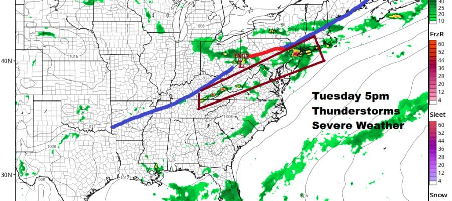
Severe Weather Flash Flood Risks Tuesday Severe Weather Likely
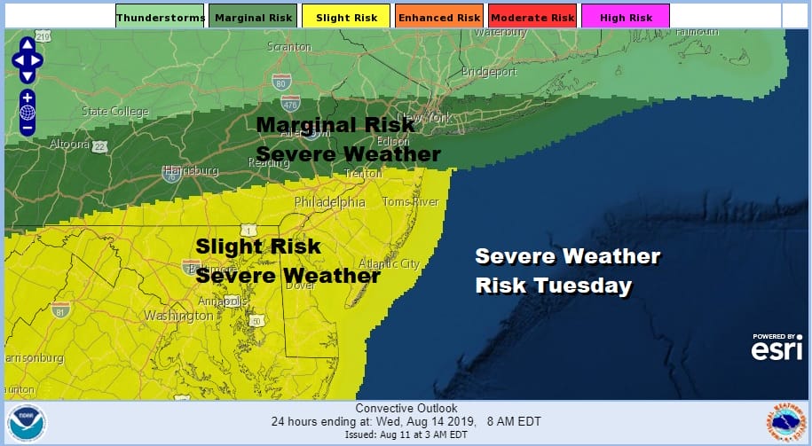
We are looking at a widespread risk for severe weather later Tuesday afternoon into Tuesday night. We don’t see any important changes in the outlook for severe weather based on the afternoon weather model series. All the pieces are there in the atmosphere. We have increasing instability, increasing humidity with dew points into the 70s, a sharp frontal boundary approaching, and ample daytime heating which will be key as to the northern extent of severe weather.

The first Flash Flood Watches have been posted for much of New Jersey and Southeastern Pennsylvania. Some of these thunderstorms will produce several inches of rain in a short period time and over areas that are still saturated from last week’s severe weather. Look for additional flash flood watches to go up on Tuesday.
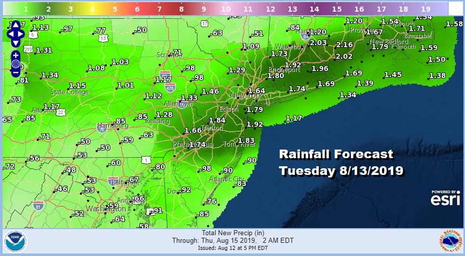
Rainfall estimates are generally in the 1 to 2 inch range with lower amounts as you go further north and further south away from the maximum risk areas however I would caution that with thunderstorms there is always huge variability in rainfall amounts depending on where the severe storms set up.
SATELLITE

Obviously there are no weather issues this evening into much of tonight as we have some high clouds around with heavier clouds to the north and to the west as low pressure approaches from out of the Ohio Valley. Temperatures won’t drop as much tonight as in past night and they should settle mostly in the 60s to near 70.
REGIONAL RADAR

Tuesday will be very warm and much more humid. Dew points will be pushing into the 70s. How much daytime heating and where the warm sector sets up will determine the severity of the thunderstorms and who gets them. Lately the best approach is to recognize your relative risk as the maps above show and prepare accordingly. We will have to wait to see what the satellite, radar, and the observations tell us tomorrow regarding heating and we will take it from there.

Wednesday will see slow improvement from north to south but the front will be dropping slowly southward and that could delay improving weather conditions over Southern New Jersey and Southeastern Pennsylvania while we should see some breaks of sunshine develop north of NYC. Highs will reach into the 80s. There could be a few leftover showers or a thunderstorm over southern areas on Wednesday.

Thursday and Friday will be a delicate balance between the high to the north and the stalled frontal boundary to the south. We still think that boundary is far enough south to prevent any serious issues other than clouds. There will be more of a northeast wind in play which will keep temperatures cooler..in the upper 70s along the coast and in a range of 80 to 85 inland. For now we will leave any mention of widespread showers and just cover for the possibility of a pop up shower or thunderstorm for the rest of the work week, mainly south and well west of NYC.
MANY THANKS TO TROPICAL TIDBITS FOR THE USE OF MAPS
Please note that with regards to any tropical storms or hurricanes, should a storm be threatening, please consult your local National Weather Service office or your local government officials about what action you should be taking to protect life and property.


