Severe Weather & Flash Flood Risks Continue Today As Steamy Weather Continues
Overnight showers and thunderstorms have moved away to the east and we have another day of steamy weather ahead for Eastern Pennsylvania to Southern New England. Winds today will be mostly from the east and southeast and that will help keep temperatures down some. Highs will be in the low to mid 80s away from the coast and 70s along south and east facing shorelines. Humidity levels remain elevated and we will continue to mention the risk for scattered thunderstorms. The Storm Prediction Center has reduced the risk for thunderstorms keeping us out of the severe zone today however I would not completely rule out scattered thunderstorms this afternoon and evening. There is the chance that there could be an isolated severe thunderstorm.
SATELLITE WITH LIGHTNING STRIKES
WEATHER RADAR
The weather outlook for the next several days is fairly straight forward since we really won’t have any kind of change in air mass. Canada is basically cut off from the United States as far as bringing down cooler dry air is concerned. We will see the risk for thunderstorms every day in the afternoon and evening and there could be some isolated severe thunderstorms in the mix through the weekend.
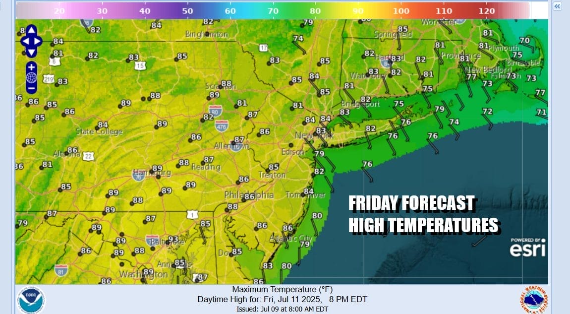
Humidity will be high into Monday of next week and so will the unstable atmosphere. We may get a short break from scattered thunderstorms next Tuesday and Wednesday but it will remain very warm to hot and it will also remain very humid. Friday brings scattered thunderstorms the the risk for isolated severe storms. Most high temperatures will be in the 80s.
Saturday and Sunday will be very warm and humid with some sunshine, scattered thunderstorms, the chance for a stronger storm remains but most of the time on both weekend days it will be rain free. Temperatures will top out in the mid to upper 80s. Nighttime lows will be mostly in the 70s except for a few 60s well inland west and north. Temperatures along the coast will be a little cooler with the winds being more from or south southeast through Sunday.
BE SURE TO DOWNLOAD THE FREE METEOROLOGIST JOE CIOFFI WEATHER APP &
ANGRY BEN’S FREE WEATHER APP “THE ANGRY WEATHERMAN!
MANY THANKS TO TROPICAL TIDBITS FOR THE USE OF MAPS
Please note that with regards to any severe weather, tropical storms, or hurricanes, should a storm be threatening, please consult your local National Weather Service office or your local government officials about what action you should be taking to protect life and property.