Severe Thunderstorms Pennsylvania Forecast Weakening Tonight
Severe Thunderstorms Pennsylvania
Forecast Weakening Tonight
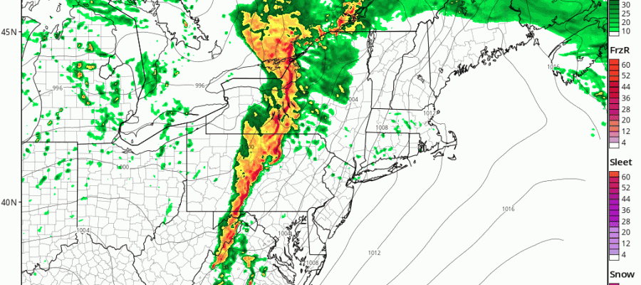
Looking at the satellite and radar loops this afternoon we are seeing a flare up of strong thunderstorms developing across Western Pennsylvania. The large spring storm in the Midwest is spinning away as it moves northeastward. It seems that the storms will maintain strength through this evening as they move across Pennsylvania but they will probably lose support as they move across New Jersey, New York City & Long Island later tonight.
The marine layer is rather stubborn along the coast where temperatures are struggling this afternoon. West and south of the warm front however the atmosphere remains supportive. While some showers and thunderstorms are forecast to survive the trip across Pennsylvania, it would seem that the severe weather threat will most likely shift northward tonight with less impact for our area.
SATELLITE LOOP

REGIONAL RADAR

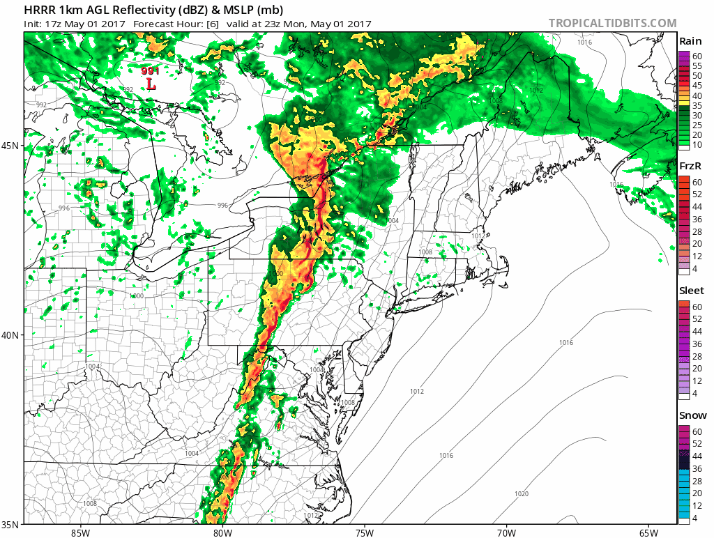
The latest HRRR model from 7pm to Midnight shows how the line of storms weakens as it moves east. This seems to make sense to me given the condition of the lower atmosphere.
HRRR MODEL FORECAST 7PM MONDAY TO 1AM TUESDAY
Once this front passes offshore weather conditions will improve Tuesday with developing sunshine and highs in the upper 60s and lower 70s. Cooler weather arrives Wednesday with some sunshine and highs in the low to middle 60s. After that another storm system from the Southern Plains will head east for Thursday and Friday and we stand a good chance of seeing some heavy rains Thursday night and Friday. The pattern will keep the chance for showers in throughout the weekend though it won’t be raining all the time.
 GET JOE A CIGAR IF YOU LIKE

LANDSCAPE COMPANIES FOR YOUR NEEDS
LONG ISLAND ROCKLAND COUNTY Connecticut

![]()

ROCKLAND COUNTY TRI STATE SNOW REMOVAL JOHNSTOWN PA


FiOS1 News Weather Forecast For Long Island
FiOS1 News Weather Forecast For New Jersey
FiOS1 News Weather Forecast For Hudson Valley
NATIONAL WEATHER SERVICE SNOW FORECASTS
LATEST JOESTRADAMUS ON THE LONG RANGE
Weather App

Don’t be without Meteorologist Joe Cioffi’s weather app. It is really a meteorologist app because you get my forecasts and my analysis and not some automated computer generated forecast based on the GFS model. This is why your app forecast changes every 6 hours. It is model driven with no human input at all. It gives you an icon, a temperature and no insight whatsoever.
It is a complete weather app to suit your forecast needs. All the weather information you need is right on your phone. Android or I-phone, use it to keep track of all the latest weather information and forecasts. This weather app is also free of advertising so you don’t have to worry about security issues with your device. An accurate forecast and no worries that your device is being compromised.
Use it in conjunction with my website and my facebook and twitter and you have complete weather coverage of all the latest weather and the long range outlook. The website has been redone and upgraded. Its easy to use and everything is archived so you can see how well Joe does or doesn’t do when it comes to forecasts and outlooks.
Just click on the google play button or the apple store button on the sidebar for my app which is on My Weather Concierge. Download the app for free. Subscribe to my forecasts on an ad free environment for just 99 cents a month.
Get my forecasts in the palm of your hand for less than the cost of a cup of Joe!


