Severe Thunderstorms, Heavy Rain, Flooding Possible Sunday
Interior Mid Atlantic & Northeast

Severe Thunderstorms, Heavy Rain, Flooding Possible Sunday
Interior Mid Atlantic & Northeast
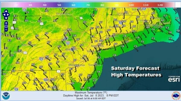
The weekend begins with a day of partly sunny skies, a southeast wind, high humidity, and very warm temperatures. A weak upper trough will approach this afternoon along with a weak frontal boundary. That could set off some scattered afternoon and evening thunderstorms with the highest chances inland. However they will be scattered in nature and therefore some of you might see a downpour or a thunderstorm but most of you want. Temperatures this afternoon will be in the mid to upper 80s with temperatures about 10 degrees lower at the shore.
SATELLITE WITH LIGHTNING STRIKES

WEATHER RADAR

There are no issues for the overnight other than it will be very warm and humid with some patchy fog and lows in the mid 60s inland to low 70s near the coast. Sunday we see a strong disturbance that will be moving out of the Tennessee and lower Ohio Valley, making a turn northward up the east side of the Appalachians.

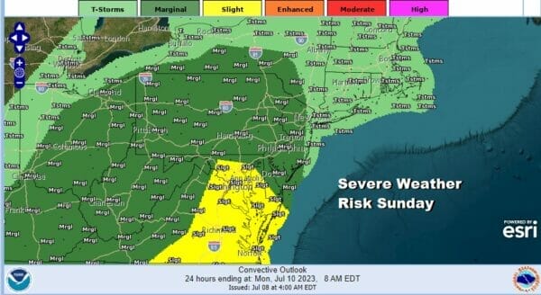
This disturbance is going to set off an area of heavy rain and thunderstorms. There is also the risk for some severe thundestorms and the Storm Prediction Center has a marginal (5 percent ) chance for severe weather. A slight risk (15%) chance is posted for Delaware and Maryland southward.
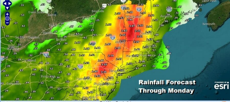
The larger risk however lies in the potential for heavy rain and here is where it gets a little tricky. The main thrust of the system will be inland so rainfall amounts along the coast, New Jersey coastal counties, Long Island, Southern and Southeastern New England, will likely be an inch or less but to the west of that area across Western New Jersey, Eastern Pennsylvania northeast into interior Southern and Central New England, rainfall amounts could easily exceed 3 inches in some places.
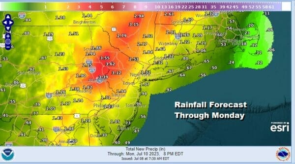
This puts the inland areas at risk for flash flooding and the Weather Prediction Center has a rather large geographic area of flash flood potential at a slight risk or a 15 to 40 percent chance for localized flash flooding. The main threat time will be Sunday dayside into Sunday evening from south to north.

The southeast wind feeds in the moisture and highs Sunday will be in the upper 70s to lower 80s though once the rain begins, temperatures will settle back into the 70s. Once the system passes we will have leftover clouds overnight into Monday morning with lows in the mid 60s to lower 70s.
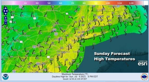
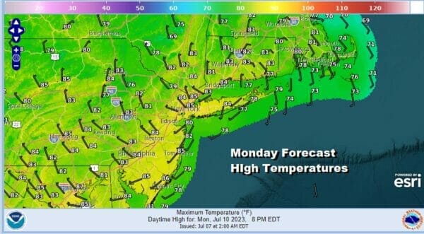
Monday looks to be a day of leftover clouds and partly sunny skies. We can’t rule out the chance for a nother shower or thunderstorm but the best chances probably lie north and east in New England rather than areas to the southwest. Monday high temperatures will reach the 80s.
Much of next week looks relatively uneventful with sunshine likely each day Tuesday through Friday. It is likely to be very warm and humid all the way through though thunderstorm chances will be limited to late Thursday and Friday and right now they do not appear to be widespread in nature.
BE SURE TO DOWNLOAD THE FREE METEOROLOGIST JOE CIOFFI WEATHER APP &
ANGRY BEN’S FREE WEATHER APP “THE ANGRY WEATHERMAN!
MANY THANKS TO TROPICAL TIDBITS FOR THE USE OF MAPS
Please note that with regards to any severe weather, tropical storms, or hurricanes, should a storm be threatening, please consult your local National Weather Service office or your local government officials about what action you should be taking to protect life and property.
(Amazon is an affilate of Meteorologist Joe Cioffi & earns commissions on sales.)


