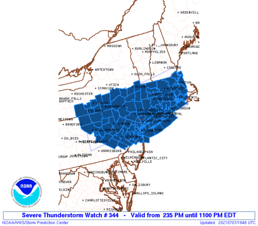
Severe Thunderstorm Watch Until 11pm
Tropical Storm Watches & Warnings Delaware to Southern New England

Weather in 5/Joe & Joe Weather Show Latest Podcast
Severe Thunderstorm Watch Until 11pm
Tropical Storm Watches & Warnings Delaware to Southern New England
A Severe Thunderstorm Watch continues until 11pm for much of Eastern Pennsylvania to Southern New England including the Hudson Valley, Northern New Jersey, NYC and Long Island. Thunderstorms will come a little later than they did yesterday with the main threat coming after 6 or 7pm.
Ample daytime heating took highs into the 90s in many locations and dew points are in the 70s making for another juicy atmosphere. Now we wait and see how another upper trough and cold front in the northwest flow triggers storm development in the next several hours.
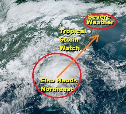
SATELLITE

Radars are picking up on thunderstorms moving across upstate NY moving east southeast. We are watching the regional radar for additional development of storms as the front approaches. This front will stall out nearby and it will create a path for Tropical Storm Elsa to move along it. Once the storms are done tonight we will remain warm and humid with lows in the upper 60s to mid 70s.
WEATHER RADAR


Let’s move on to Thursday where not much happen other than it is very warm and very humid but not quite as hot as today (though it will still feel rather miserable). Highs will be in the mid 80s to around 90. There could be a pop up shower or thunderstorm in the afternoon but the main action will be from Tropical Storm Elsa Thursday night into Friday morning.
TROPICAL STORM ELSA LATEST ADVISORY
…ELSA MOVING INTO SOUTHERN GEORGIA ACCOMPANIED BY VERY HEAVY
RAINS…
SUMMARY OF 500 PM EDT…2100 UTC…INFORMATION
———————————————-
LOCATION…30.8N 83.4W
ABOUT 115 MI…185 KM WSW OF BRUNSWICK GEORGIA
MAXIMUM SUSTAINED WINDS…45 MPH…75 KM/H
PRESENT MOVEMENT…N OR 10 DEGREES AT 14 MPH…22 KM/H
MINIMUM CENTRAL PRESSURE…1003 MB…29.62 INCHES
WATCHES AND WARNINGS
——————–
CHANGES WITH THIS ADVISORY:
A Tropical Storm Watch has been issued for Long Island from East
Rockaway Inlet to the eastern tip along the south shore and from
Port Jefferson Harbor to the eastern tip along the north shore.
A Tropical Storm Watch has been issued for the coast of southern
New England from New Haven, Connecticut to Sagamore Beach,
Massachusetts including Cape Cod, Block Island, Martha’s Vineyard,
and Nantucket.
All warnings have been discontinued along the Florida Gulf coast.
SUMMARY OF WATCHES AND WARNINGS IN EFFECT:
A Tropical Storm Warning is in effect for…
* Mouth of St. Marys River, Georgia to Little River Inlet, South
Carolina
A Tropical Storm Watch is in effect for…
* North of Little River Inlet, South Carolina to Sandy Hook, New
Jersey
* Pamlico and Albemarle Sounds
* Chesapeake Bay south of North Beach and the tidal Potomac south
of Cobb Island
* Delaware Bay south of Slaughter Beach
* Long Island from East Rockaway Inlet to the eastern tip along the
south shore and from Port Jefferson Harbor eastward on the north
shore
* New Haven, Connecticut to Sagamore Beach, Massachusetts including
Cape Cod, Block Island, Martha’s Vineyard, and Nantucket.
A Tropical Storm Warning means that tropical storm conditions are
expected somewhere within the warning area.
A Tropical Storm Watch means that tropical storm conditions are
possible within the watch area.
WHAT TO EXPECT NEW JERSEY
Based on a track that takes Elsa just barely offshore the coast of New Jersey, the primary impact from Elsa will be rain. It will move in from South to north Thursday night and end Friday morning. The main threat time will be from midnight to 8 or 9 am Friday. (plus or minus 2 hours). Along the immediate coast winds could be strong and gusty at times out of the east and then shifting to the north as the low goes by. I don’t anticipate big problems from the wind if the track is just offshore and Elsa remains on the weak side. It will all depend on an upper trough over the Great Lakes and what kind of influence it has on Elsa. Rainfall amounts will be in the 1 to 2 inch range.
WHAT TO EXPECT HUDSON VALLEY
Assuming a coastal slightly offshore track, the main impact will be rain from 1am to 11am Friday (give or take an hour or two) with some heavy downpours. Rainfall amounts here could also be in the 1 to 1.5 inch range. Wind should not be a big issue though along the shores of Long Island Sound it could get gusty at times. After the rain ends, weather conditions should improve in the afternoon though another shower or thunderstorm going into the evening Friday can’t be ruled out.
WHAT TO EXPECT LONG ISLAND & SOUTH COASTAL CONNECTICUT
The forecast track will bring the center of Elsa very close to Long Island Friday morning. The big overhanging question is an upper trough over the Great Lakes and whether Elsa responds to that by strengthening a bit as it approaches. That is a tough call at this point. This will be a 6 to 8 hour event. Rain will be on the order of up to 2 inches or so and there could be some localized flooding.

The period of time to watch will be from midnight Friday to noon Friday with the worst of it in the hours approaching daybreak until about 8 or 9am. Winds are a tougher call because that will depend on the track. If the low center passes to say NYC, we would be on the east side with likely less rain and more wind. If the center cuts Long Island in half then conditions will be different west of the low verses east. Also we don’t know how strong the low will be and if it doesn’t react to the upper trough over the Great Lakes, then we could see a weaker system that is more of a nuisance then anything else. These variables need more time for us to resolve and we have all day Thursday to figure that out. Once Elsa goes by to our north weather conditions should improve Friday though another shower or thunderstorm is possible in the evening. Then we move a head to a warm and humid weekend with only a slight chance for a pop up downpour or thunderstorm each afternoon.
BE SURE TO DOWNLOAD THE FREE METEOROLOGIST JOE CIOFFI WEATHER APP &
ANGRY BEN’S FREE WEATHER APP “THE ANGRY WEATHERMAN!

MANY THANKS TO TROPICAL TIDBITS & F5 WEATHER FOR THE USE OF MAPS
Please note that with regards to any severe weather, tropical storms, or hurricanes, should a storm be threatening, please consult your local National Weather Service office or your local government officials about what action you should be taking to protect life and property.


