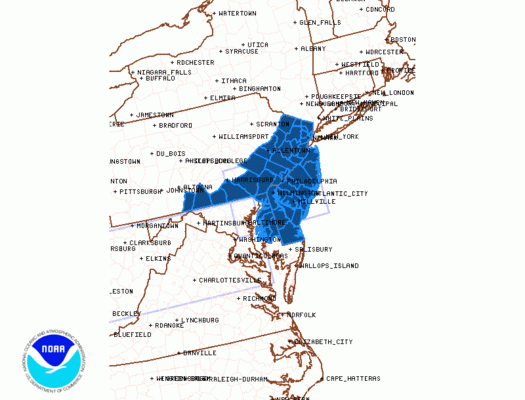
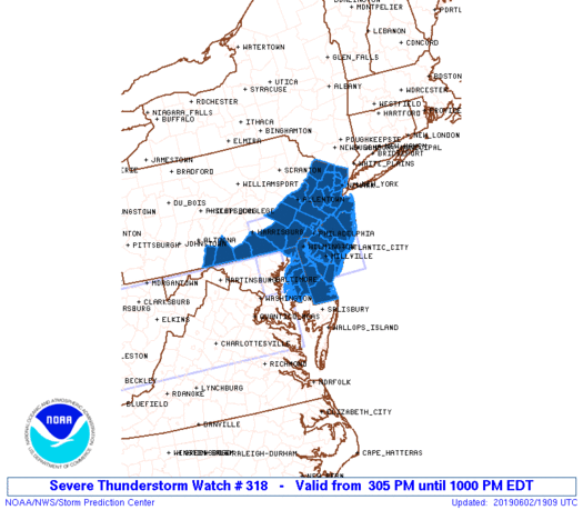
Severe Thunderstorm Watch New Jersey Eastern Pennsylvania
NEW JERSEY COUNTIES INCLUDED ARE
ATLANTIC BERGEN BURLINGTON
CAMDEN CAPE MAY CUMBERLAND
ESSEX GLOUCESTER HUDSON
HUNTERDON MERCER MIDDLESEX
MONMOUTH MORRIS OCEAN
PASSAIC SALEM SOMERSET
SUSSEX UNION WARREN
We are beginning to see thunderstorms developing in linear fashion across Pennsylvania this afternoon. Earlier this afternoon the Storm Prediction Center put up a severe thunderstorm watch from West Virginia to Maryland. Now they have added an additional Severe Thunderstorm Watch that covers much of Eastern Pennsylvania and all of New Jersey. The watch is in effect until 10pm tonight.
Meanwhile the daytime heating continues as temperatures have risen into the 80s in many areas away from the shore this afternoon. The cold front still lies well to the west and judging by what is on the radar at the moment we might have to push the thunderstorm threat time back a couple hours. I would suspect any threats from thunderstorm will likely occur after 5pm and before 10pm from west to east.
SATELLITE

REGIONAL RADAR

Radars are showing active thunderstorms developing across West Virginia and Western Maryland. A line of thunderstorms is developing separate from the southern area across Western Pennsylvania and that is moving eastward. We are also picking up on some renegade thunderstorms that have formed out well ahead of the main line of storms. Those storms are in Southeastern Pennsylvania and Southern New Jersey and they are also moving to the east.
LOCAL RADAR NEW YORK CITY

LOCAL RADAR PHILADELPHIA


Once the front moves through tonight the thunderstorms will come to an end and cooler air arrives. By morning lows will be in the 50s. Monday will be partly sunny in most places but there will be a gusty wind and temperatures just in the 60s to near 70 at best. A very cool night is forecast for Monday night into Tuesday morning. Lows Tuesday under clear skies will be in the low 50s in warmer urban centers but many areas inland will be in the 40s and cool spots well north and west of the coast will be in the 30s! Tuesday looks nice and sunny with highs in the low to mid 70s.
MANY THANKS TO TROPICAL TIDBITS FOR THE USE OF MAPS
Please note that with regards to any tropical storms or hurricanes, should a storm be threatening, please consult your local National Weather Service office or your local government officials about what action you should be taking to protect life and property.