Severe Hurricane Dorian 150 MPH Winds Continues West
Florida Risk Diminishing
LOCATION…26.1N 73.9W
ABOUT 205 MI…325 KM E OF GREAT ABACO IN THE BAHAMAS
ABOUT 385 MI…625 KM E OF WEST PALM BEACH FLORIDA
MAXIMUM SUSTAINED WINDS…150 MPH…240 KM/H
PRESENT MOVEMENT…W OR 280 DEGREES AT 8 MPH…13 KM/H
MINIMUM CENTRAL PRESSURE…945 MB…27.91 INCHES
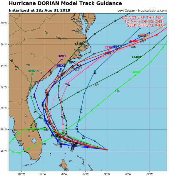
Some good news for Florida in that we have another model cycle underway that keeps Dorian away from the Florida east coast. This lends confidence to the eastward trend that began yesterday and continued overnight and today. Perhaps with one or two more cycle runs we may put the Florida risk to bed. The turn to the north does increase the risk to North and South Carolina coasts with models bringing Dorian very close to the coastline but keeping (just) offshore. This would be for Wednesday into Thursday as Dorian responds to the northern jet stream coming down and accelerating it away to the northeast. The active northern jet stream will keep Dorian on a path away from the Northern Middle Atlantic states to Southern New England so it will be no threat to us except for rough up the coastal waters.
SATELLITE
The pinprick eye in this strong category 4 hurricane highlights what has been an outstanding presentation on the satellite pictures today. There is probably some sort of eye wall replacement cycle that it is going to go through but between now and late Sunday there could be one more surge strengthening to bring this to a category 5 for a short time. The Northern Bahamas will be in serious trouble with this as the hurricane is forecast to be over them later Sunday and then take until Tuesday to start the northward motion away from them.
REGIONAL RADAR
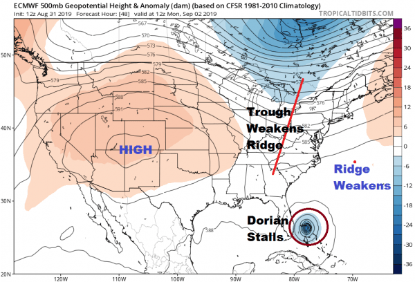
All along it has been the upper high in the Atlantic that has the driving force and the key to how far west Dorian would get. Earlier this week weather models were showing an approaching short wave trough into the Eastern US on Monday would be weak. This trough is stronger than forecast and strong enough to weaken the western portion of the upper high. This puts Dorian in between the upper high in the Atlantic and the upper high that is in the Western US.
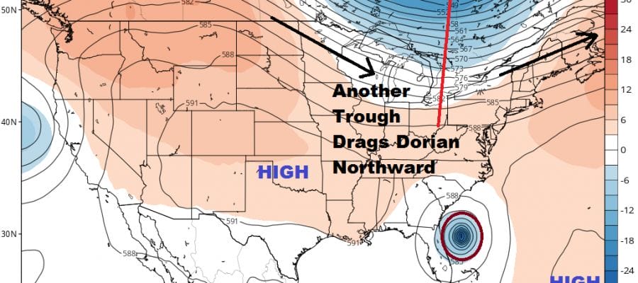
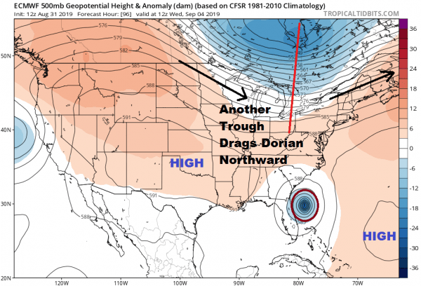
While the the first trough moves away and doesn’t pick up Dorian, the upper highs then build back strongly in both directions. This would create an issue and turn Dorian back to the west. However there is a second short wave that comes down from Canada on Wednesday which keeps the ridges from connecting; leaving a weakness for Dorian to respond to. It does so by moving northward toward the South and North Carolina coast for midweek.
This could be an issue for the Carolina’s however there is another trough that will be swinging southeast from Canada that turns the hurricane to the northeast before any kind of landfall occurs. It will be a very close call however. You can see on the loop of the upper air steering below how it all plays out. Dorian is like a football about to be punted away.
This is still a close enough call for the Carolina’s that we need to play close attention here. Any change in strength in either the trough or the upper high could make the difference between a landfall and coast raking verses an offshore miss. Some of the new hurricane model guidance pick up on a track slightly to the left though most of the models are clustered just offshore.
One thing either way is that Dorian will weaken from its current severe intensity once it starts moving northward and away from the high octane water temperatures in the mid to upper 80s in and around the Bahamas so even if it were to threaten the Carolina coast it will be not nearly as strong as what we are seeing now. The hurricane’s circulation will be expanding so it is likely that coastal South and North Carolina will see some rain from this even if it tracks offshore. Obviously much is still in flux for the mid range forecast period here, but the odds are growing that the East Coast of Florida will avoid a direct hit. We will wait one more model cycle to put that to bed and then focus on the Carolinas for the middle of next week.
MANY THANKS TO TROPICAL TIDBITS FOR THE USE OF MAPS
Please note that with regards to any tropical storms or hurricanes, should a storm be threatening, please consult your local National Weather Service office or your local government officials about what action you should be taking to protect life and property.


