
Seasonal Conditions Mostly Rain Free Next 5 Days
No Impact From Dorian
We are going into a stretch of mainly rain free dry conditions for the next 5 days or so. This is typical for September which in most years is a dry time as summer ends and autumn begins. We have seen summer weather getting extended into October in past years though those seemed to have shortened somewhat in the last two autumns. The next 5 days will be dry for the most part even though we have Hurricane Dorian to our south and two weak cold fronts that will be coming through this weekend. Some high clouds from Dorian are already overhead today on the satellite picture. We will see sunshine being masked by Dorian induced high clouds today. The 80s from yesterday are done and highs to day will be mostly in the 70s as the wind turns light northeasterly.
SATELLITE

REGIONAL RADAR

Nothing much at all is happening on many of the local radars in the Northeast and Middle Atlantic states but below are two very active radars today from Charleston South Carolina and Wilmington North Carolina. This is of course from Hurricane Dorian, a category 3 hurricane with top winds of 115 mph. We have seen numerous tornado warnings overnight and those show up as red boxes on the radars. Yellow boxes are severe thunderstorm warnings. The eye will be visible on both radar views through much of the day.
LOCAL RADAR WILMINGTON NC

LOCAL RADAR CHARLESTON


The initial view on Dorian was that a northwest flow in the upper atmosphere would keep it away from Eastern Pennsylvania to Southern New England including all the major metro areas from Washington to NYC and this remains the case today. Clouds will continue to increase tonight with lows in the 50s to lower 60s. Friday we will see lots of clouds around with highs just into the 70s.
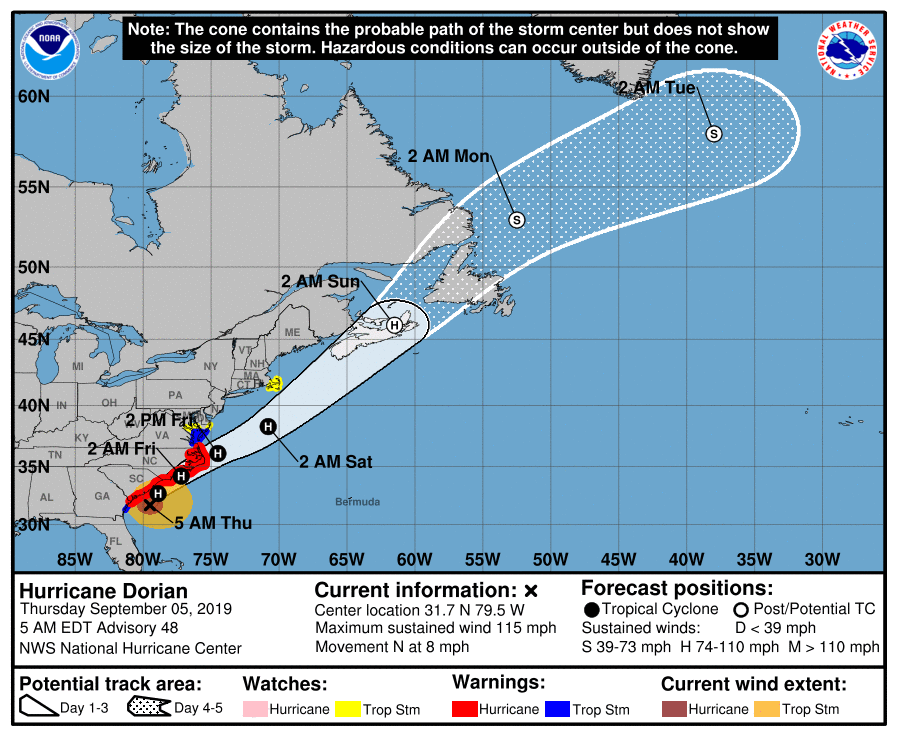
The official forecast for Dorian has it passing well south and east of New Jersey and Long Island. Only minimal impacts if any will occur later Friday into Friday night as Dorian goes by. Look for rain and wind to reach Southeastern New England for awhile with tropical storm watches up for that area. Then it is on to Nova Scotia and New Foundland Saturday as a major post tropical cyclone. This drives dry air to us this weekend with two weak cold fronts. Saturday look for a mix of sun and clouds with highs in the 70s. Sunday sees a second weak front going by with sun and clouds. Monday looks mostly sunny with highs both days in the upper 60s to mid 70s.
MANY THANKS TO TROPICAL TIDBITS FOR THE USE OF MAPS
Please note that with regards to any tropical storms or hurricanes, should a storm be threatening, please consult your local National Weather Service office or your local government officials about what action you should be taking to protect life and property.


