Redevelopment Secondary Low Key To Snow Forecast
Redevelopment Secondary Low Key To Snow Forecast
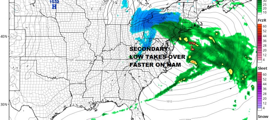
Everything regarding this coastal storm seems to be coming into line here regarding rain wind and coastal flooding The snow question remains wide open at the moment. It hinges on the redevelopment of the coastal low and how fast does the energy from the primary low transfer to the secondary. The reason why the NAM model continues to come in colder and snowier than the other models along the coast is the transfer of energy on the NAM occurs faster than the other models.
NAM MODEL FORECAST 1AM FRIDAY
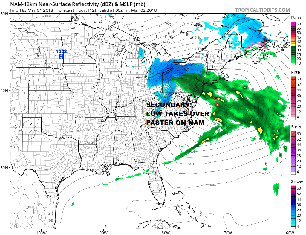
GFS MODEL FORECAST 1AM FRIDAY
The faster the secondary develops the better the chance for cold air to drain southward on the west side as the upper air dynamics swing into play. We won’t know until it happens so we will just watch and wait. In the meantime the satellite loop shows clouds from the primary low increasing rapidly as all this energy begins to swing toward the Delaware/ New Jersey coast.
US SATELLITE

REGIONAL RADAR

Radars are starting to load up the rain to the north represents the rain from the primary low as it moves east. To the south of that across Virginia and North Carolina is the rain from the beginnings of the secondary low. Both areas are moving quickly to the east.
LOCAL RADAR NEW YORK CITY

LOCAL RADAR PHILADELPHIA


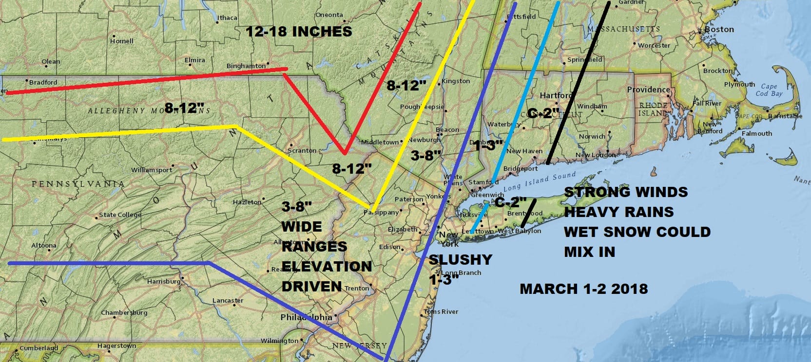
Look for rain to develop from west to east over the next 3 or 4 hours. Then it rains all night into Friday morning. Then the games begin regarding the change over to snow. The late afternoon NAM model and the short range HRRR models are lined up almost the same. The NAM continues to paint an aggressive snow picture inland and puts the coast at risk for some slushy accumulations. I don’t see any reason at this point to change my original forecast. Bear in mind that for coastal area forecasts for snow into Western Connecticut are the ones that probably have the greatest risk for going wrong. I have to tell you that my confidence in this forecast is low at this point and will probably remain so until tomorrow morning when we could start getting the answers to the snow question.
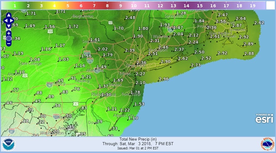
As far as rainfall is concerned 2 to 3 inches I believe is doable and since we have seen ample rain lately, flooding is possible in poor drainage areas.
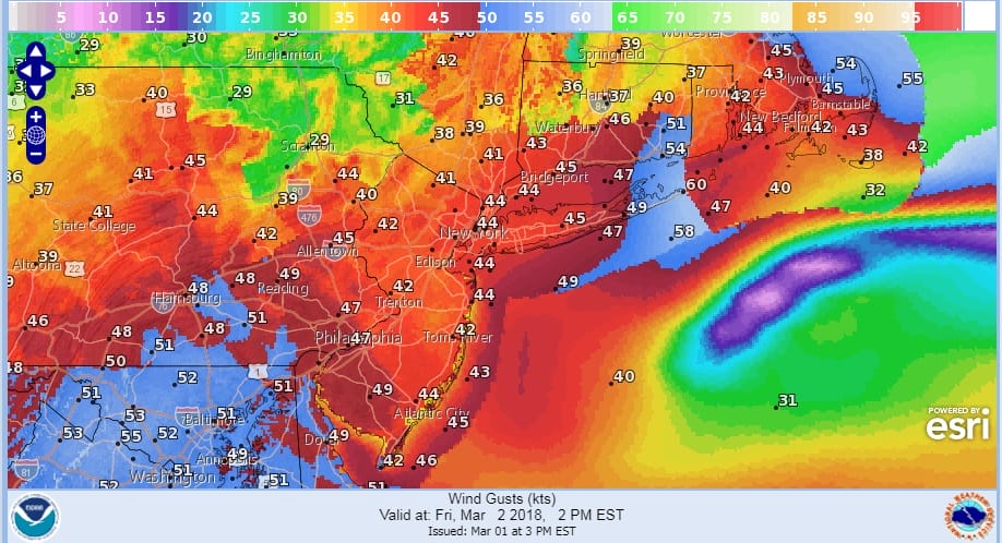
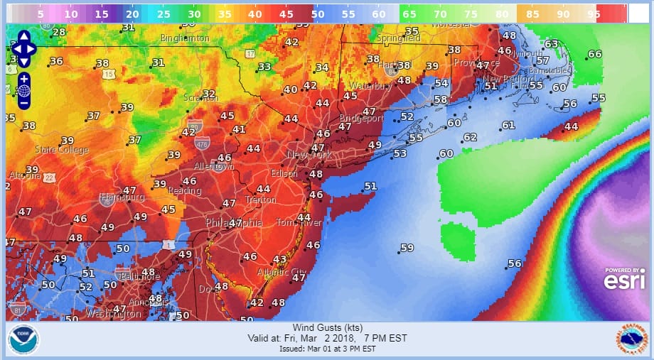
As far as the wind is concerned the strongest winds will be later in the day Friday into Friday evening. Here are the forecast wind gusts at 2pm and 7pm Friday
FORECAST WINDS 2PM FRIDAY
FORECAST WINDS 7PM FRIDAY
Coastal flooding at high tide is likely. Tides will run up to 3 feet above normal with moderate coastal flooding likely on long island and minor to moderate coastal flooding expected for New Jersey. Tides will likely be a problem right through the weekend with this storm remaining offshore for the next several days. Precipitation should come to an end overnight into Saturday morning with weather conditions improving during Saturday though it will still remain windy. Sunshine and chilly conditions are forecast for Sunday.
 GET JOE A CIGAR IF YOU LIKE

FiOS1 News Weather Forecast For Long Island
FiOS1 News Weather Forecast For New Jersey
FiOS1 News Weather Forecast For Hudson Valley


